Village and town development state measurement method based on remote sensing noctilucent dark target enhancement technology

A target enhancement and dark target technology, which is applied in the field of village and town development state measurement based on remote sensing night light and dark target enhancement technology, can solve the problems of village and town level dark target development state measurement, small value of village and town level light data, and difficulty in direct detection. , to improve the recognition ability, avoid noise interference, and achieve the effect of robust detection

Active Publication Date: 2021-07-23
INST OF GEOGRAPHICAL SCI & NATURAL RESOURCE RES CAS
View PDF11 Cites 4 Cited by
  • Summary
  • Abstract
  • Description
  • Claims
  • Application Information

AI Technical Summary

Problems solved by technology

[0004] However, there are few studies in the existing technology that apply remote sensing night light data to the detection of dark targets at the level of villages and towns. There are two main reasons for this. Due to the characteristics of detection and other characteristics, the value of the light data at the village and town level is generally small, and the light area is relatively small, so it is difficult to detect directly; Level 1 night light data has a low signal-to-noise ratio and is not easy to identify
[0005] Moreover, due to the limitations of the scope of application and processing methods of remote sensing night light data, the use of remote sensing night light data alone is not enough to directly measure the development status of dark targets at the level of villages and towns.

Method used


Image

  • Village and town development state measurement method based on remote sensing noctilucent dark target enhancement technology
  • Village and town development state measurement method based on remote sensing noctilucent dark target enhancement technology
  • Village and town development state measurement method based on remote sensing noctilucent dark target enhancement technology

Examples


Embodiment Construction

[0034] In order to better understand the above-mentioned purpose, features and advantages of the present application, the present application will be further described in detail below in conjunction with the accompanying drawings and specific embodiments. It should be noted that, in the case of no conflict, the embodiments of the present application and the features in the embodiments can be combined with each other.

[0035] In the following description, a lot of specific details are set forth in order to fully understand the application, however, the application can also be implemented in other ways different from those described here, therefore, the protection scope of the application is not limited by the following disclosure Limitations of specific embodiments.

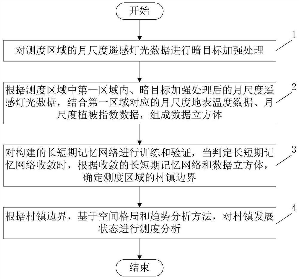
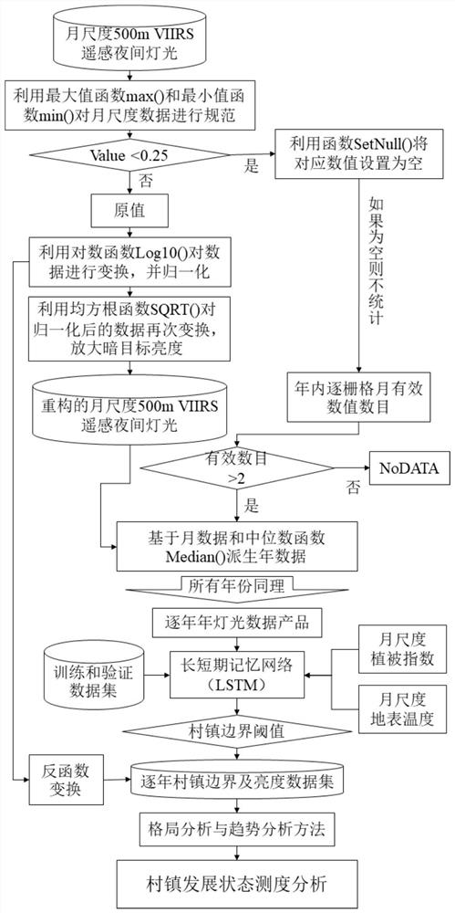
[0036] Such as figure 1 and figure 2 As shown, this embodiment provides a method for measuring the development status of villages and towns based on remote sensing night light and dark target enhancement techn...


PUM


Abstract

The invention discloses a village and town development state measurement method based on a remote sensing noctilucent dark target enhancement technology. The method comprises the following steps: 1, carrying out dark target enhancement processing on monthly-scale remote sensing light data of a measurement area; 2, forming a data cube according to the monthly-scale remote sensing light data subjected to dark target enhancement processing in a first area in the measurement area in combination with monthly-scale surface temperature data and monthly-scale vegetation index data corresponding to the first area; 3, training and verifying the constructed long-short-term memory network, and when it is determined that the long-short-term memory network converges, determining the town boundary of the measurement area according to the convergent long-short-term memory network and the data cube; and 4, according to the boundaries of the villages and the towns, based on a spatial pattern and a trend analysis method, performing measurement analysis on the development states of the villages and the towns. According to the technical scheme of the invention, the method effectively improves the recognition capability of the first-level dark targets of villages and towns, and guarantees that the enhancement of the dark targets is not affected by obvious noise.

Description

technical field [0001] This application relates to the technical fields of geography and remote sensing science, and specifically relates to a method for measuring the development status of villages and towns based on remote sensing night light and dark target enhancement technology. Background technique [0002] Rural revitalization has become a major national strategy and an important measure for China to solve the "three rural" issues, and it is gradually becoming a common action of the whole society. Rural economic development is one of the important indicators to detect rural development. The traditional method of obtaining rural economic development is mainly through social surveys and statistical means. However, this method of obtaining usually requires a lot of time and personnel costs. [0003] Modern remote sensing technology, especially the emergence of night light data, provides an important reference for detecting social and economic development on a macro scal...

Claims


Application Information

Patent Timeline
Patent Type & Authority Applications(China)
IPC IPC(8): G06K9/00G06N3/04G06N3/08G06Q50/26
CPCG06N3/08G06Q50/26G06V20/13G06N3/044
Inventor 刘正佳刘彦随钟会民李裕瑞王介勇
Owner INST OF GEOGRAPHICAL SCI & NATURAL RESOURCE RES CAS
Why Eureka
Try Eureka