Ground-based laser radar aerosol inversion method and system based on laser radar satellite

A laser radar and aerosol technology, applied in the field of atmospheric remote sensing, can solve the problems of aerosol inversion error, aerosol extinction coefficient inversion error, etc., and achieve the effect of reducing restrictions, good accuracy and strong stability

Active Publication Date: 2021-09-03
WUHAN UNIV
View PDF6 Cites 4 Cited by
  • Summary
  • Abstract
  • Description
  • Claims
  • Application Information

AI Technical Summary

Problems solved by technology

However, there are two disadvantages in the Fernald method: first, the extinction backscattering ratio of the aerosol needs to be selected based on empirical values, and the aerosol is one of the most active molecules in the atmosphere, and the extinction backscattering ratio of the aerosol is It is constantly changing with the physical and chemical content of the atmosphere, which introduces a large error to the inversion of the aerosol extinction coefficient; second, the calibration altitude is determined by seeking a clean atmosphere, but it basically does not exist in the actual troposphere The altitude at which the aerosol content is 0, on the other hand, due to factors such as air pollution, it is difficult to conduct lidar observations covering a large area from low altitude to high altitude, which brings inevitable errors to aerosol inversion

Method used


Image

  • Ground-based laser radar aerosol inversion method and system based on laser radar satellite
  • Ground-based laser radar aerosol inversion method and system based on laser radar satellite
  • Ground-based laser radar aerosol inversion method and system based on laser radar satellite

Examples


Embodiment Construction

[0028] The technical solution of the present invention will be further described below in conjunction with the accompanying drawings.

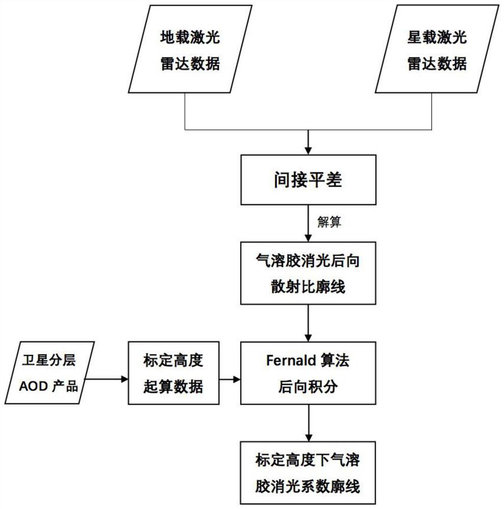
[0029] see figure 1 , the embodiment of the present invention provides a ground-based lidar aerosol inversion method based on lidar satellites, using the AOD layered products of lidar satellites to calculate atmospheric parameters at a certain height to improve accuracy, including the following steps:

[0030] Step 1, based on the indirect adjustment, using the equations measured by the ground-based lidar and the spaceborne lidar to solve the profile of the aerosol extinction backscatter ratio in one cycle;

[0031] The preferred implementation of this step is as follows:

[0032] Set up monitoring stations under the passing area of ​​the spaceborne lidar, and conduct ground-based lidar observations during the satellite transit time period, so as to obtain multiple ground-based lidar equations and a spaceborne lidar equation at the height r f...


PUM


Abstract

The invention provides a ground-based laser radar aerosol inversion method and system based on a laser radar satellite, and the method and system are combined with a ground-based laser radar and a satellite-borne laser radar to improve the aerosol profile concentration inversion precision. The inversion process comprises the following steps: based on indirect adjustment, using equations measured by a ground laser radar and a satellite-borne laser radar to calculate a profile of an aerosol extinction backscattering ratio in a period; according to a layered AOD product of the satellite-borne laser radar, determining the height of an initial boundary point and aerosol characteristics of the height, and determining an initial calculation value of a backward integral; and according to the determined aerosol extinction backscattering ratio and the signal of the ground-based laser radar, using an aerosol extinction coefficient formula deduced by using a Fernald method to calculate an aerosol extinction coefficient at a certain height, and further obtaining the aerosol optical thickness. According to the invention, when pollution is serious and weather conditions are poor, accurate data can be obtained, and not only is good precision achieved, but also high stability is achieved.

Description

technical field [0001] The invention relates to the field of atmospheric remote sensing, in particular to a ground-based laser radar aerosol retrieval method and system based on laser radar satellites, which effectively utilizes laser radar satellites to improve the accuracy of the laser radar-based aerosol profile concentration retrieval. Background technique [0002] The impact of aerosols on the global atmospheric environment is mainly manifested in three aspects: First, aerosols have the characteristics of absorbing and scattering incident light from the sun, which can affect global and regional climate change by changing the solar radiation balance. At the same time, aerosols can also cause environmental problems, causing regional haze and dust pollution, and adversely affecting human health. Finally, aerosols can act as condensation nuclei for clouds, affecting the water cycle in the atmospheric environment. The "London smog" and "Los Angeles smog" in history are very...

Claims


Application Information

Patent Timeline
Patent Type & Authority Applications(China)
IPC IPC(8): G01S17/95G01S7/48
CPCG01S17/95G01S7/4802Y02A90/10
Inventor 钟琬溱马昕龚威韩舸史天奇张豪伟邱若楠张家兴王成义王苗苗
Owner WUHAN UNIV
Why Eureka
Try Eureka