Method for adjusting earth pointing angle of satellite

A technology for angle adjustment and direction adjustment, which is applied in the directions of space navigation equipment, space navigation aircraft, space navigation aircraft guidance devices, etc., and can solve problems such as affecting altimeters and structural deformation.

Pending Publication Date: 2021-09-07
AEROSPACE DONGFANGHONG SATELLITE
View PDF0 Cites 2 Cited by
  • Summary
  • Abstract
  • Description
  • Claims
  • Application Information

AI Technical Summary

Problems solved by technology

[0006] The purpose of the present invention is: to overcome the deficiencies of the prior art, to propose a method for adjusting the pointing angle of the satellite to the ground, and to solve

Method used


Image

  • Method for adjusting earth pointing angle of satellite
  • Method for adjusting earth pointing angle of satellite
  • Method for adjusting earth pointing angle of satellite

Examples


Embodiment Construction

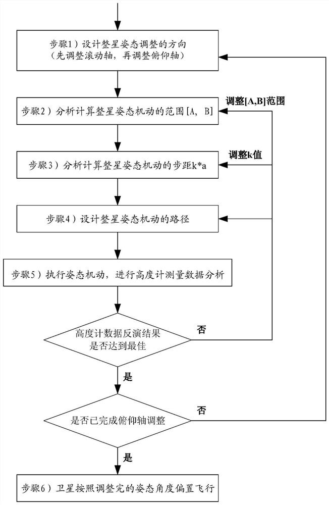
[0052] In order to solve the above-mentioned technical problems, the present invention proposes a method for adjusting the pointing angle of the satellite to the ground, the process is as follows figure 1 shown, including the following steps:

[0053] Step 1: Design the direction of the whole star attitude maneuver adjustment

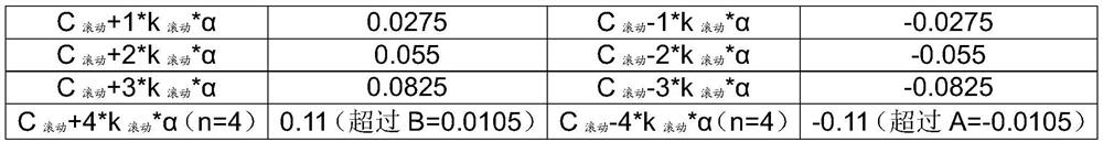
[0054] The attitude maneuver directions that can be adjusted by the satellite in orbit are roll, pitch and yaw. Among them, the yaw axis is the vector of the satellite body pointing vertically to the surface, that is, the direction in which the altimeter signal is emitted. Rotating around the yaw axis of the star body will not change the angle and path of the altimeter signal. Therefore, only the roll axis and the pitch axis need to be considered for the whole-star attitude maneuver adjustment.

[0055] The function of satellite attitude maneuver adjustment is realized by the on-board attitude control subsystem. For attitude control subsystems that u...


PUM


Abstract

The invention discloses a method for adjusting an earth pointing angle of a satellite, and aims at correcting an altimeter signal transmitting beam pointing deviation caused by structural deformation before and after a satellite enters an orbit through a whole satellite attitude offset method. The method comprises the following steps: designing a whole-satellite attitude maneuvering adjustment direction; analyzing and calculating an angle range of maneuvering adjustment of the whole-satellite attitude; analyzing and calculating the angle step pitch of maneuvering adjustment of the whole satellite attitude; designing a whole-satellite attitude maneuver path; executing attitude maneuver, and carrying out altimeter measurement data analysis; and enabling that the satellite flies in an offset manner according to the adjusted attitude angle. The method is suitable for satellites equipped with altimeters.

Description

technical field [0001] The invention belongs to the field of satellite design and relates to a method for adjusting the pointing angle of a satellite to the ground. Background technique [0002] The main function of altimetry satellites is to measure surface elevation information, and two measurement methods, active and passive, can be used. The passive altimetry payload is an optical remote sensing camera, and the active altimetry payload is an altimeter, generally including a microwave altimeter or a laser altimeter. The altimeter has the ability to actively transmit signals and receive the reflected signals after the signals it sends are reflected by the ground. It requires that the direction of the signal it transmits must be very precisely perpendicular to the earth's surface at the sub-satellite point of the satellite, so that the received reflected signal will be almost the shortest path, which can be used for inversion to obtain ground elevation information. This p...

Claims


Application Information

Patent Timeline
IPC IPC(8): B64G1/24
CPCB64G1/244B64G1/245
Inventor 阎诚莫鑫王丽丽黄耀辉
Owner AEROSPACE DONGFANGHONG SATELLITE
Why Eureka
Try Eureka