Monitoring method of urban haze pollution parameters based on medium and high resolution remote sensing images

A remote sensing image, high-resolution technology, applied in instruments, computing, character and pattern recognition, etc., can solve the problems of missing data, error transmission, low spatial resolution, etc., to achieve the effect of solving error transmission

Active Publication Date: 2022-05-13
SHANDONG JIAOTONG UNIV
View PDF6 Cites 0 Cited by
  • Summary
  • Abstract
  • Description
  • Claims
  • Application Information

AI Technical Summary

Problems solved by technology

[0003] The technical problem to be solved by the present invention is to provide a method for monitoring urban haze pollution parameters based on medium and high-resolution remote sensing images, so as to solve the problem of low spatial resolution in remote sensing monitoring of haze, and prone to data loss and errors in urban areas. The problem of fewer haze pollution parameters for transmission and remote sensing monitoring

Method used


Image

  • Monitoring method of urban haze pollution parameters based on medium and high resolution remote sensing images
  • Monitoring method of urban haze pollution parameters based on medium and high resolution remote sensing images
  • Monitoring method of urban haze pollution parameters based on medium and high resolution remote sensing images

Examples


Embodiment 1

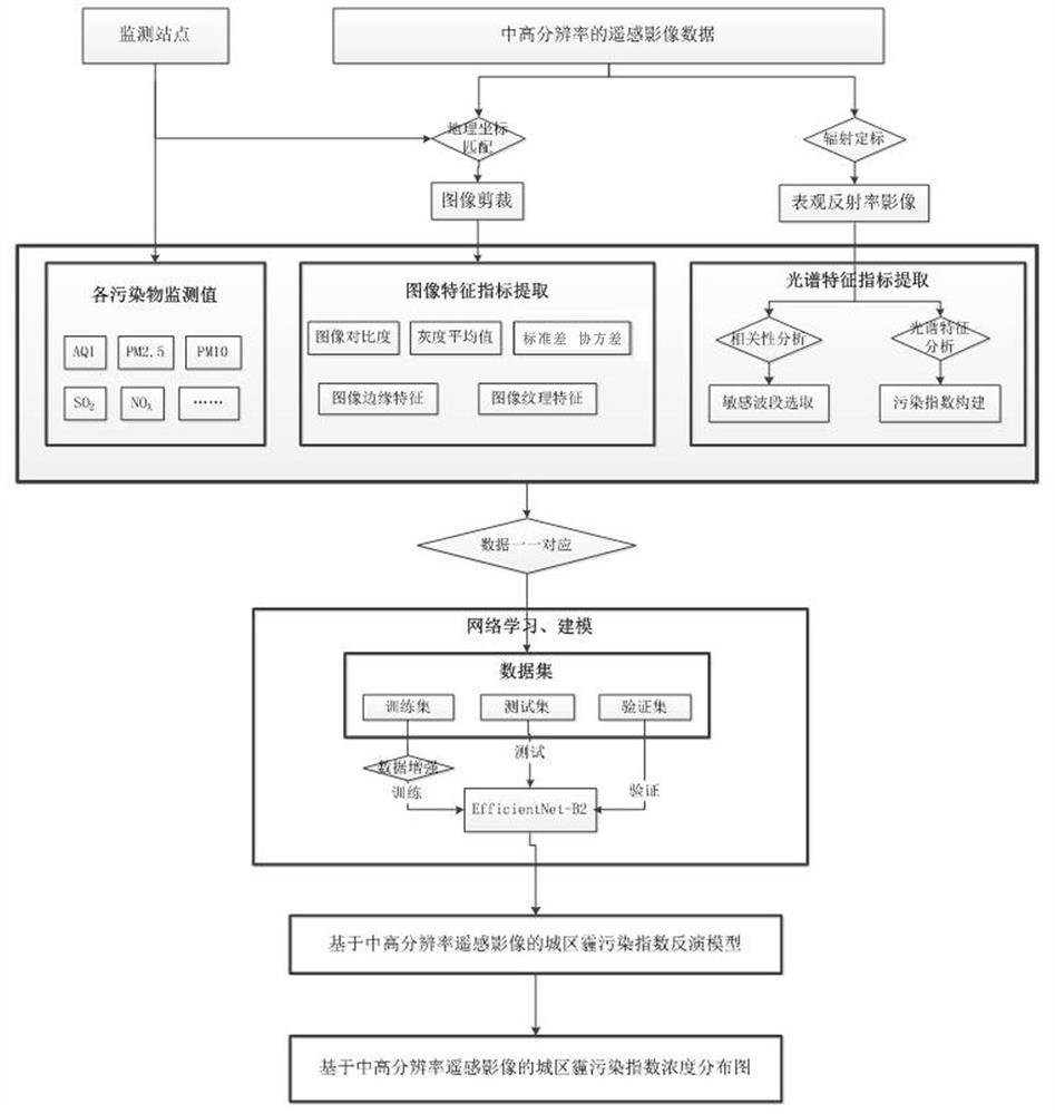
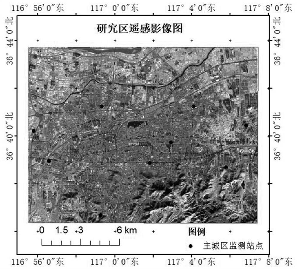
[0020] This embodiment discloses a method for monitoring urban haze pollution parameters based on medium and high-resolution remote sensing images. This embodiment takes the urban area of ​​Jinan City as an example, such as figure 1 shown, including the following steps:

[0021] S01), the arrangement of monitoring sites is based on the existing environmental monitoring sites of national control points and provincial control points, and additional environmental monitoring sites sensitive to traffic data are added in the area near road intersections. The environmental monitoring sites in this embodiment are as follows As shown in Table 1, monitoring stations have been added at the intersection of Jingshi Road and Lishan Road where the traffic flow is relatively large;

[0022]

[0023] S02), acquisition of remote sensing image data: Landsat8OLI (30m resolution) was selected as the remote sensing image, and 20 scene image data from 2015 to 2018 were selected as the time, cover...


PUM


Abstract

The invention discloses a method for monitoring urban fog and haze pollution parameters based on medium and high resolution remote sensing images. The method monitors urban fog and haze pollution parameters based on medium and high resolution images. Based on medium and high resolution remote sensing images, it can solve the problem of remote sensing monitoring fog The problem of low spatial resolution exists during haze. At the same time, additional monitoring stations are deployed to match the monitoring station data with remote sensing image data, and then through data cutting, spectral feature selection, and network training and learning, so as to monitor multi-haze pollution parameters. Solve the problems of error transmission, less haze pollution parameters of remote sensing monitoring, etc., and can monitor AQI, PM2.5, PM10, NO in urban areas X , SO2, CO, HC, Q3 and other pollution parameters.

Description

technical field [0001] The invention relates to the fields of remote sensing image processing and aerosol monitoring, in particular to a method for monitoring urban haze pollution parameters based on medium and high resolution. Background technique [0002] The monitoring data of ground monitoring stations has good time continuity, and the monitoring method based on remote sensing makes up for the lack of spatial discontinuity of the monitoring station method. The method of estimating PM2.5 concentration based on remote sensing is currently widely used: Chen Liangfu et al. applied for a patent "method and system for joint inversion of ground PM2.5 by geostatistical interpolation and satellite remote sensing" Guo Hong et al. applied for a patent "a method based on satellite polarization PM2.5 Concentration Remote Sensing Estimation Method Based on Advanced Technology”, Liu Yang et al. applied for a patent “Ground PM2.5 Retrieval Method and System Based on Satellite Remote Sen...

Claims


Application Information

Patent Timeline
Patent Type & Authority Patents(China)
IPC IPC(8): G06V20/10G06V10/26G06V10/44G06V10/46G06V10/54G06V10/774G06V10/82G06K9/62
CPCG06F18/214
Inventor 冯海霞
Owner SHANDONG JIAOTONG UNIV
Why Eureka
Try Eureka