Real-time high-precision global multi-dimensional tropospheric zenith delay grid model construction method

A construction method and high-precision technology, applied in design optimization/simulation, special data processing applications, etc., can solve problems such as insufficient spatial resolution and single data source, reduce model parameters, solve problems with low spatial resolution, The effect of improving computational efficiency

Active Publication Date: 2021-05-21
GUILIN UNIVERSITY OF TECHNOLOGY
View PDF1 Cites 0 Cited by
  • Summary
  • Abstract
  • Description
  • Claims
  • Application Information

AI Technical Summary

Problems solved by technology

[0004] Through the above analysis, the existing problems and defects of the existing technology are: (1) the spatial resolution of the vertical profile model of the troposphere is not fine enough; (2) the model construction uses a single data source

Method used


Image

  • Real-time high-precision global multi-dimensional tropospheric zenith delay grid model construction method
  • Real-time high-precision global multi-dimensional tropospheric zenith delay grid model construction method
  • Real-time high-precision global multi-dimensional tropospheric zenith delay grid model construction method

Examples


Embodiment 1

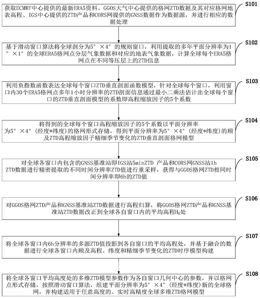
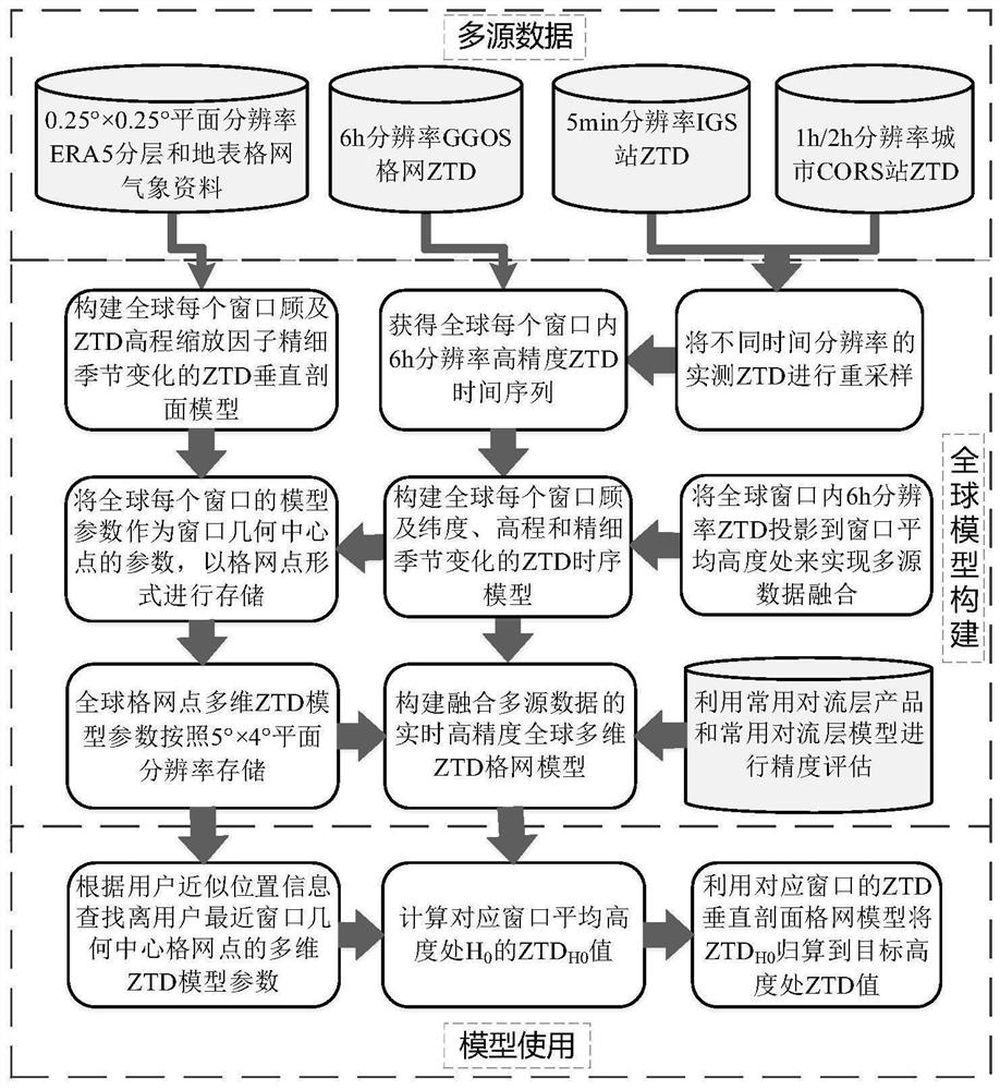
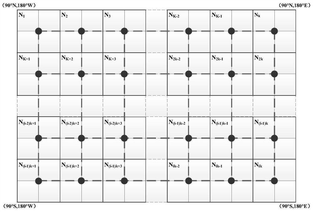
[0123] (1) Data source introduction and processing. The data sources involved in the model construction of the present invention are: the latest ERA5 data provided by the ECMWF Center, the grid ZTD data provided by the GGOS Atmospheric Center and its corresponding grid surface elevation, the ZTD products provided by the IGS Center and the GNSS data provided by the CORS network. The horizontal resolution of the ERA5 reanalysis data is 0.25°×0.25°, the time resolution is 1h, and the vertical resolution is 37 isobaric layers; the horizontal resolution of the GGOS atmospheric grid ZTD product is 2.5°×2° (longitude *latitude), the time resolution is 6h; the IGS Center provides ZTD products of thousands of GNSS reference stations around the world, the time resolution is 5min, and the accuracy is better than 5mm; for the GNSS reference station data provided by the CORS network, the Bernese The precision GNSS processing software calculates the ZTD information of each GNSS reference st...


PUM


Abstract

The invention belongs to the cross technical field of satellite navigation and positioning system data processing and meteorology, discloses a real-time high-precision global multi-dimensional tropospheric zenith delay grid model construction method, introduces a sliding window algorithm to divide the whole world into 5°×4° Regular window, using ERA5 data to construct a ZTD vertical profile model that takes into account the fine seasonal variation of the ZTD elevation scaling factor in each window around the world, and then constructs a 5°×4° global ZTD vertical profile grid model. In the present invention, the multidimensional ZTD model parameters at the average elevation of each window in the world are used as the parameters of the geometric center of each window, and stored in the form of grid points, and a new global grid is formed according to the sliding window algorithm, and a real-time grid applicable to any height is constructed. High-precision global multi-dimensional ZTD grid model. The real-time high-precision global multi-dimensional ZTD grid model established by the present invention better improves the calculation efficiency of the model and enhances the practicability of the model.

Description

technical field [0001] The invention belongs to the interdisciplinary technical field of global navigation satellite system (GNSS) data processing and meteorology, and in particular relates to a real-time high-precision global multi-dimensional tropospheric zenith delay grid model construction method. Background technique [0002] At present, tropospheric delay is a key factor affecting high-precision navigation and positioning of space technologies such as Global Navigation Satellite System (GNSS) and Very Long Baseline Interferometry (VLBI), and it is also the basic data of atmospheric science research. At present, the tropospheric delay model is mainly used to provide tropospheric delay information. Traditional tropospheric delay models are mainly divided into two categories, one is the model that requires meteorological parameters, and the other is the model without meteorological parameters. Tropospheric delay models that require measured meteorological parameters have...

Claims


Application Information

Patent Timeline
Patent Type & Authority Patents(China)
IPC IPC(8): G06F30/20
CPCG06F30/20
Inventor 黄良珂彭华刘立龙黎峻宇康传利谢劭峰
Owner GUILIN UNIVERSITY OF TECHNOLOGY
Why Eureka
Try Eureka