Area positioning navigation system based on traffic sign information line and working method thereof
A traffic sign and area positioning technology, which is applied in the field of positioning and navigation, can solve the problems of high cost, increased cost, and poor positioning accuracy, and achieve the effects of low cost, reduced investment in transformation, and high accuracy of positioning and recognition
- Summary
- Abstract
- Description
- Claims
- Application Information
AI Technical Summary
Problems solved by technology
Method used
Image

Examples
Embodiment 1
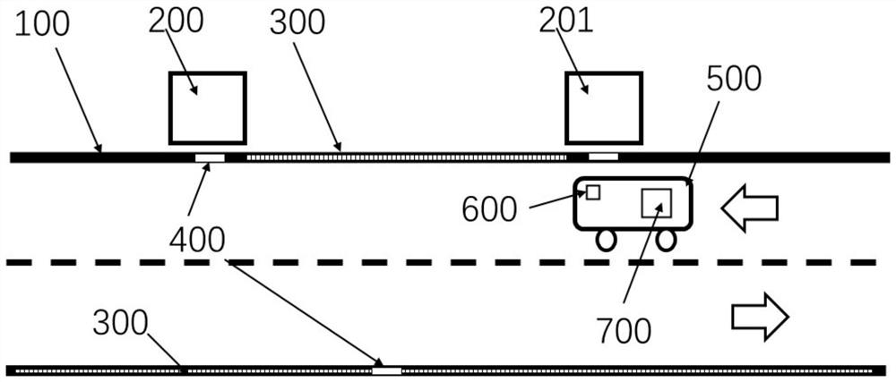
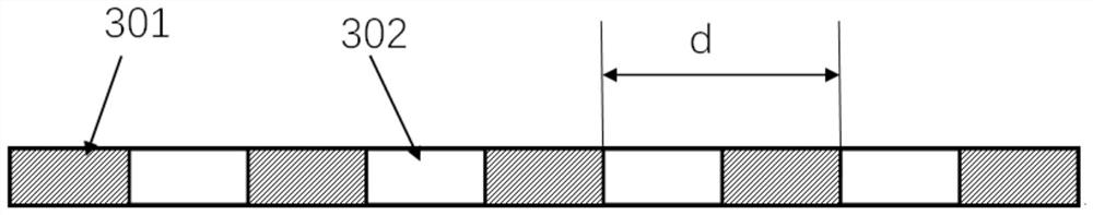
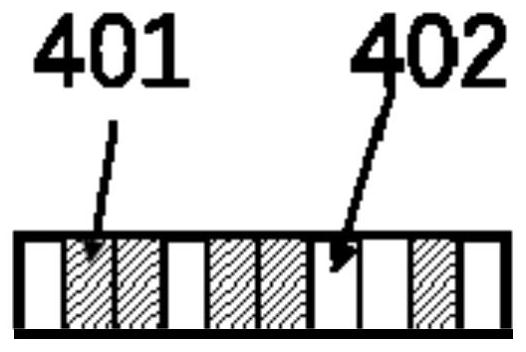
[0041] like figure 1As shown, the regional positioning and navigation system based on the traffic sign information line of this embodiment includes the traffic sign information line 100 containing distance and position information, the video acquisition unit 600, the control unit 700 and the mobile unit 500, wherein the traffic sign information line 100 is laid on the road in the area, and the video acquisition unit 600 and the control unit 700 are installed on the mobile unit 500; when the mobile unit 500 moves in the area, the video acquisition unit 600 collects the image of the traffic sign information line 100, and the control unit 700 recognizes and calculates The location information and moving distance of the point are obtained, and the navigation of the mobile unit 500 is realized in combination with the electronic map of the area. figure 1 In the specific position A 200 and the specific position B 201, the binary code information line 400 is installed, and the equidis...
Embodiment 2
[0053] The regional positioning and navigation system based on the traffic sign information line of the present embodiment, such as Figure 4 The application scenario of the underground parking lot is shown in the figure. In the underground parking lot, equidistant information lines 300 are laid along both sides of the road in the parking lot. All parking spaces and other key points such as elevator entrances, garage entrances and exits, and different driveways A binary code information line 400 is laid, and the binary code corresponding to each position is unique. The underground parking lot is equipped with a parking space status monitoring system. The real-time status information of the parking space and the electronic map of the parking lot are all stored in the cloud background. In this embodiment, the mobile unit 500 is a vehicle with an automatic driving function, and there are built-in video cameras around the vehicle body. When the car owner drives the mobile unit 50...
Embodiment 3
[0055] The regional positioning and navigation system based on the traffic sign information line of the present embodiment, such as Figure 5 The application scenario of on-street parking space inspection is shown in the figure. The roadside parking charging system usually installs a parking space detector on the parking space to detect the state change of the parking space, and uses a video patrol car to collect the vehicle license plate information on the parking space, and then links the parking space status information with the license plate information through the patrol car positioning , forming a charging order. In this embodiment, the traffic sign information line 100 is used to collect and identify information, such as Figure 5 As shown, the traffic sign information line 100 is also installed on the regional road of the parking space, and the parking space line 400 including the parking space of each roadside parking space 204 is laid with a binary code information ...
PUM
 Abstract
Description
Claims
Application Information
 - R&D
- Intellectual Property
- Life Sciences
- Materials
- Tech Scout
- Unparalleled Data Quality
- Higher Quality Content
- 60% Fewer Hallucinations
Browse by: Latest US Patents, China's latest patents, Technical Efficacy Thesaurus, Application Domain, Technology Topic, Popular Technical Reports.
© 2025 PatSnap. All rights reserved.Legal|Privacy policy|Modern Slavery Act Transparency Statement|Sitemap|About US| Contact US: help@patsnap.com