Remote sensing image cultivated land information extraction method based on convolutional neural network

A convolutional neural network and remote sensing image technology, applied in the field of remote sensing image farmland information extraction based on convolutional neural network, can solve problems such as affecting the accuracy of information extraction results, time-consuming and laborious, and difficult to obtain information.

Pending Publication Date: 2021-09-14
中国煤炭地质总局勘查研究总院
View PDF0 Cites 3 Cited by
  • Summary
  • Abstract
  • Description
  • Claims
  • Application Information

AI Technical Summary

Problems solved by technology

[0002] Agriculture is the foundation of the national economy. Cultivated land is the lifeblood of agricultural development and agricultural modernization, and the cornerstone of national food security. Cultivated land area and spatial distribution information are basic data in agricultural fields such as precision agriculture and food production. Therefore, it is possible to accurately and quickly investigate cultivated land The spatial distribution of land is crucial to human production and life, national supervision and management, and cultivated land protection; at present, manual statistics or traditional remote sensing monitoring methods are usually used to estimate the cultivated land area, and artificial statistical methods are easily affected by human factors and difficult to obtain. Acquiring information quickly is time-consuming and laborious; remote sensing technology has the characteristics of wide coverage and short detection period, and can quickly extract the spatial distribution and area of ​​cultivated land; traditional remote sensing image supervised classification methods use shallow feature extraction, which is difficult to extract The effective features of pixels, in addition, too much manual participation is required, which affects the accuracy of information extraction results

Method used


Image

  • Remote sensing image cultivated land information extraction method based on convolutional neural network
  • Remote sensing image cultivated land information extraction method based on convolutional neural network
  • Remote sensing image cultivated land information extraction method based on convolutional neural network

Examples


Embodiment 1

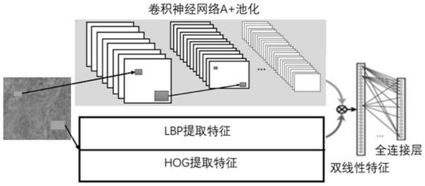
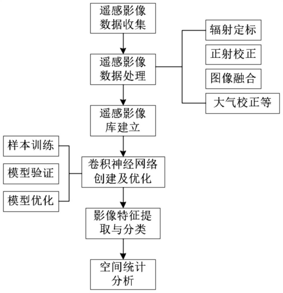
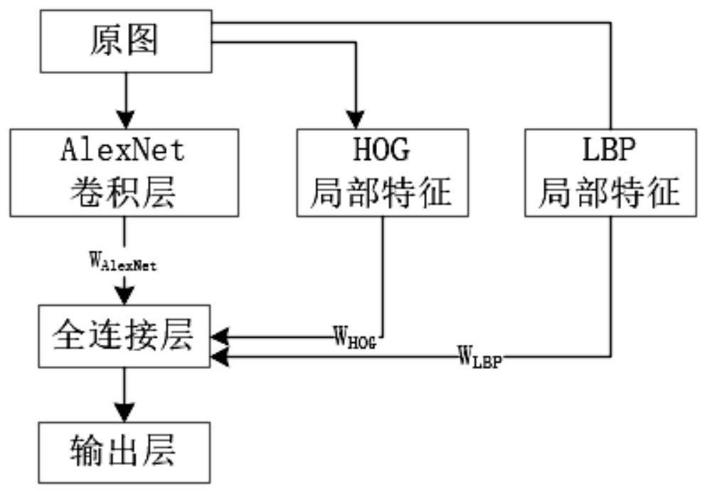
[0033] like Figure 1 to Figure 3 The shown remote sensing image cultivated land information extraction method based on convolutional neural network, the method is as follows:

[0034] A. Data preprocessing. The landsat8 image data of a certain area is used as the data source. Since the remote sensing image will be deformed to a certain extent during the imaging process, it is necessary to use ENVI5.3 software to preprocess the image data before image recognition and classification. It is necessary to preprocess the image to enhance the image quality and restore the real information of the image; to enhance the image quality and lay a good foundation for image recognition; to process the remote sensing image data through ENVI5.3 software, including radiometric calibration and orthorectification , image fusion, information enhancement and image cropping, and finally get a remote sensing image with high resolution;

[0035] B. Construct a remote sensing image database. The remote...


PUM


Abstract

The invention discloses a remote sensing image cultivated land information extraction method based on a convolutional neural network, and the method comprises the following steps: A, data preprocessing: carrying out the processing of remote sensing image data through ENVI5.3 software, including radiometric calibration, ortho-rectification, image fusion, information enhancement and image cutting, and finally obtaining a remote sensing image with high resolution; B, constructing of a remote sensing image library; C, establishing and training of a convolutional neural network model; D, extracting and classifying of remote sensing image information; E, spatial statistical analysis on cultivated land information. According to the invention, landsat8 image data of a certain area is used as a data source, ENVI5.3 software is used for preprocessing the image data, the time-consuming and labor-consuming problem of visual interpretation can be solved, remote sensing image data can be accurately recognized and classified, a feasible technical method is provided for research and application about remote sensing image extraction and classification in the future, the cultivated land management efficiency in China is improved, and agricultural monitoring is more scientific and modernized.

Description

technical field [0001] The invention relates to a method for extracting cultivated land information from remote sensing images, in particular to a method for extracting cultivated land information from remote sensing images based on a convolutional neural network, and belongs to the technical field of methods for extracting cultivated land information from remote sensing images. Background technique [0002] Agriculture is the foundation of the national economy. Cultivated land is the lifeblood of agricultural development and agricultural modernization, and the cornerstone of national food security. Cultivated land area and spatial distribution information are basic data in agricultural fields such as precision agriculture and food production. Therefore, it is possible to accurately and quickly investigate cultivated land The spatial distribution of land is very important to human production and life, national supervision and management, and cultivated land protection; at pre...

Claims


Application Information

Patent Timeline
IPC IPC(8): G06K9/00G06K9/46G06K9/54G06K9/62G06N3/04G06N3/08G06Q50/02G06Q50/26
CPCG06N3/08G06Q50/02G06Q50/26G06N3/045G06F18/24Y02A40/10
Inventor 林燕张衡白秀佳王铮侯言凯田力
Owner 中国煤炭地质总局勘查研究总院
Why Eureka
Try Eureka