Planar target rasterization method based on multi-level global grid

A multi-level, planar technology, applied in structured data retrieval, special data processing applications, geographic information databases, etc., can solve problems such as inability to convert results, rasterization accuracy and data redundancy, and large data redundancy , to achieve the effect of small data volume, high precision, and reduced data volume

Active Publication Date: 2021-10-15
THE 28TH RES INST OF CHINA ELECTRONICS TECH GROUP CORP
View PDF8 Cites 4 Cited by
  • Summary
  • Abstract
  • Description
  • Claims
  • Application Information

AI Technical Summary

Problems solved by technology

[0004] Land is a kind of areal target. Currently, there are two main problems in the rasterization of areal targets: (1) Consistent expression of rasterization results. Different areal targets are obtained based on different grid ...

Method used


Image

  • Planar target rasterization method based on multi-level global grid
  • Planar target rasterization method based on multi-level global grid
  • Planar target rasterization method based on multi-level global grid

Examples


Embodiment Construction

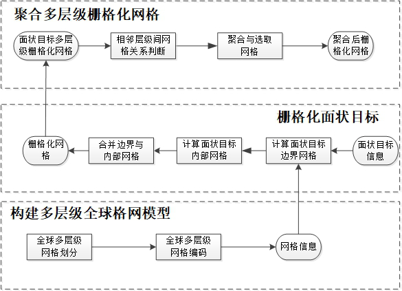
[0061] Such as figure 1 As shown, a kind of planar object rasterization method based on the multi-level global grid disclosed by the present invention specifically includes the following steps:

[0062] Step 1. Build a multi-level global grid model; select the global grid range as [-180, 180] in the longitude direction and [-90, 90] in the latitude direction, and build a multi-level global grid model within this range, including global multi-level Mesh division and global multi-level grid coding are two steps.

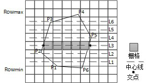
[0063] Step 2, gridding the planar target; the rasterized grid of a certain level of planar target consists of two parts: the boundary grid of the planar target and the inner grid of the planar target. According to the grid information and the boundary point set information of the surface target, calculate the rasterized grid of the surface target at a certain level, including calculating the boundary grid of the surface target, calculating the internal grid of the su...


PUM


Abstract

The invention provides a planar target rasterization method based on a multi-level global grid. The method comprises the following steps: performing multi-level grid division and coding on a global geographic space to construct a global grid model; calculating a multi-level planar target rasterized grid according to global grid model information; and aggregating the multi-level rasterized grids by adopting an aggregation mode, and selecting the aggregated rasterized grids as planar target rasterization results. According to the method, the multi-level grid model is established in the global geographic space, and the planar target at any global geographic position can be rasterized based on the same model, so that the consistency of the rasterization results is ensured; meanwhile, the aggregation mode is adopted, planar target rasterization results of multiple levels are aggregated, an aggregated grid set is selected, and the data size after planar target rasterization is greatly reduced; the minimum size of the grid reaches the second level, and the precision is high; and multi-level planar target rasterization is supported, rasterization results are aggregated, and the rasterization data volume is small.

Description

technical field [0001] The invention belongs to the field of spatial data structure conversion in geographic information systems, and in particular relates to a method for rasterizing planar objects based on multi-level global grids. Background technique [0002] The conversion of spatial data structure is a very important research branch in GIS, especially the conversion of vector data to raster data. The raster data structure refers to a data (array data) organization form that divides a two-dimensional surface into regular grid units, and uses corresponding attribute values ​​to represent geographic entities on each grid unit. Each element of raster data can be uniquely identified by rows and columns, and the number of rows and columns is determined by the resolution (or size) of the raster and the characteristics of the entity. Raster data is very beneficial for overlay analysis, area analysis, target indication and buffer analysis in spatial analysis, so it is usually ...

Claims


Application Information

Patent Timeline
IPC IPC(8): G06F16/29
CPCG06F16/29
Inventor 蓝振家彭程徐伟姜梦蝶戴高乐
Owner THE 28TH RES INST OF CHINA ELECTRONICS TECH GROUP CORP
Why Eureka
Try Eureka