Vector tile generation method and system adaptive to multiple data sources

A multi-data source, generation system technology, applied in database management systems, relational databases, database models, etc., can solve the problems of on-demand assembly, large amount of vector tile data, inability to realize cross-spatial data sources, etc., to improve compatibility sexual effect

Pending Publication Date: 2021-10-22
福建省基础地理信息中心
View PDF0 Cites 4 Cited by
  • Summary
  • Abstract
  • Description
  • Claims
  • Application Information

AI Technical Summary

Problems solved by technology

However, the traditional vector tile technology is generated by commercial software or open source tools, which has certain restrictions and requirements on the spatial data source, and cannot realize the on-demand assembly and real-time generation of data across spatial data sources; although the vector tile The amount of data is significantly lower than that of raster tiles, but affected by the scale of the map, the larger the latitude and longitude range of a tile, the more feature sets of vector data it contains, resulting in a larger amount of data for the generated vector tiles. bigger

Method used


Image

  • Vector tile generation method and system adaptive to multiple data sources
  • Vector tile generation method and system adaptive to multiple data sources
  • Vector tile generation method and system adaptive to multiple data sources

Examples


Embodiment Construction

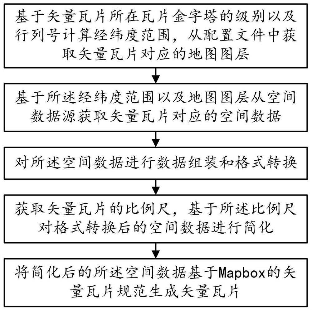
[0043] The technical solution in the embodiment of the present application has the following general idea: by automatically obtaining the spatial data corresponding to the vector tile from the spatial database of the type Oracle Spatial, SqlServer Spatial, PostGIS, MySQL Spatial, SpatiaLite, or by obtaining the spatial data corresponding to the vector tile from the type Shapefile, GeoJSON, GeoBuf, FileGDB, MDB, and KML file-type spatial data automatically obtain spatial data corresponding to vector tiles to improve the compatibility of data sources; simplify spatial data through Douglas thinning algorithm, and dynamically combine vector tiles Resolution, according to different levels to achieve optimal vector data reduction.

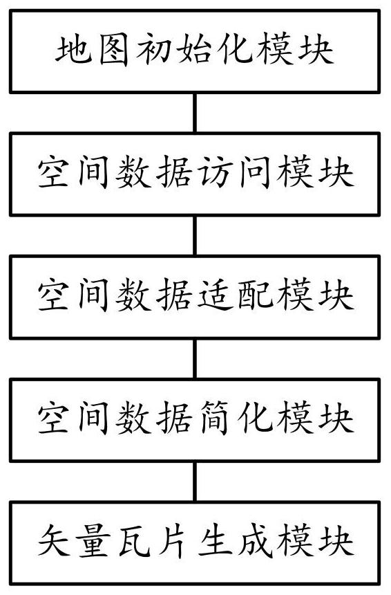
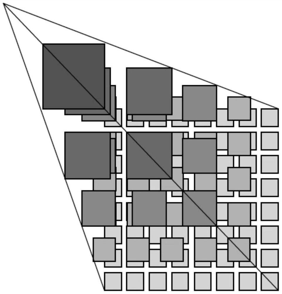
[0044] Please refer to Figure 1 to Figure 3 As shown, a preferred embodiment of a method for generating vector tiles adapted to multiple data sources in the present invention includes the following steps:

[0045] Step S10, calculating the latitude and...


PUM


Abstract

The invention provides a vector tile generation method and system adaptive to multiple data sources in the technical field of electronic maps, and the method comprises the following steps: S10, calculating a longitude and latitude range based on the level and the row and column number of a tile pyramid where a vector tile is located, and obtaining a map layer corresponding to the vector tile from a configuration file; s20, acquiring spatial data corresponding to the vector tiles from a spatial data source based on the longitude and latitude range and the map layer; step S30, carrying out data assembly and format conversion on the spatial data; step S40, acquiring a proportional scale of a vector tile, and simplifying the spatial data after format conversion based on the proportional scale; and step S50, generating a vector tile from the simplified spatial data based on a vector tile specification of Mapbox. The invention has the advantages that the data is assembled according to needs, the compatibility of the data source is greatly improved, and the data volume is greatly reduced.

Description

technical field [0001] The invention relates to the technical field of electronic maps, in particular to a method and system for generating vector tiles adapted to multiple data sources. Background technique [0002] At present, mainstream GIS platforms generally use map tile caching technology to speed up map access, so as to reduce server load and improve user experience. The map tile caching technology is to map the remote sensing image data and map vector data, generate a fixed-size raster image (raster tile) according to the scale through the mainstream GIS software, and then publish it as a standard OGC map service for customers terminal use. [0003] Since the raster image solidifies the map data and map style into the image, there are problems of low clarity and inability to modify the style. With the emergence of Mapbox open source vector tile technology, the shortcomings of the raster image are solved. It is possible to dynamically modify the map display style ac...

Claims


Application Information

Patent Timeline
Patent Type & Authority Applications(China)
IPC IPC(8): G06F16/29G06F16/28G06F16/2455G06F16/25
CPCG06F16/29G06F16/284G06F16/2455G06F16/258
Inventor 陈德权吴飞叶小卿陈俊明徐亮龚知凡王伟凡林惠英黄梦龙袁存忠余丽钰叶荣青
Owner 福建省基础地理信息中心
Why Eureka
Try Eureka