Remote sensing image processing device based on geographic information system

A geographic information system and remote sensing image technology, which is applied in the field of remote sensing image processing devices, can solve the problems of blurring, reducing the utilization value of images, and the surface of water traces on the surface of the lens, and achieves the effect of preventing the airtight effect.

Active Publication Date: 2021-10-29
CHANGCHUN INST OF TECH
View PDF6 Cites 0 Cited by
  • Summary
  • Abstract
  • Description
  • Claims
  • Application Information

AI Technical Summary

Problems solved by technology

[0003] In summary, the inventors found that the existing remote sensing image processing devices mainly have the following defects: when the remote sensing image is installed in a relatively humid geographical area for image acquisition, due to the continuous fluctuation of the humidity in the atmosphere, The water molecules in the air will directly attach to the surface of the lens that captures the image, and as the water molecules slide down through the centrifugal force, it is easy to produce corresponding moisture traces on the surface of the lens, which will blur the surface of the image captured later. The image will directly increase the processing efficiency of the image and reduce the utilization value of the image.

Method used


Image

  • Remote sensing image processing device based on geographic information system
  • Remote sensing image processing device based on geographic information system
  • Remote sensing image processing device based on geographic information system

Examples


Embodiment 1

[0028] Figure 1 to Figure 6 Shown:

[0029] The invention provides a remote sensing image processing device based on a geographic information system,

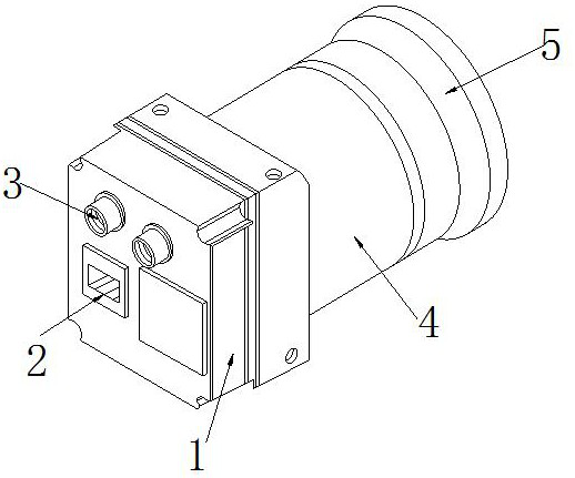
[0030] Its structure includes a control box 1, a power supply terminal 2, a processing terminal 3, a transmission block 4, and a camera 5. The control box 1 and the power supply terminal 2 are integrated, and the processing terminal 3 is electrically connected to the power supply terminal 2. The transmission block 4 is embedded in the front side of the processing terminal 3 , and the camera 5 is fixedly connected to the transmission block 4 .

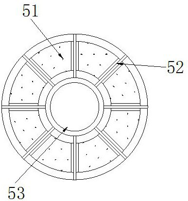
[0031] The camera 5 is provided with a solid block 51, a fixed shaft 52, and a lens block 53. The solid block 51 and the fixed shaft 52 are clearance fit, and the lens block 53 is embedded in the fixed shaft 52. The fixed shaft 52 A total of eight solid blocks 51 are provided with a corresponding gap effect between them. The fixed shaft 52 can effectively maintain the fixed effect of ...

Embodiment 2

[0039] Figure 7 to Figure 9 Shown:

[0040] The invention provides a remote sensing image processing device based on a geographic information system,

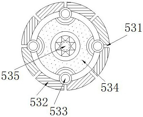
[0041] Its structure includes that the telescopic body 533 is provided with an insertion block c1, a control layer c2, a limiter c3, a push rod c4, and a moving block c5, the upper end of the insertion block c1 is attached to the control layer c2, and the limiter The body c3 is installed on both sides of the upper end of the control layer c2, the push rod d4 runs through the center of the limit body c3, the moving block c5 and the push rod c4 are in clearance fit, and the limit body c3 is in a solid state, so The limiter c3 can limit the movement space of the ejector rod c4 through its solid state to prevent deviation.

[0042] Wherein, the moving block c5 is provided with a cover plate c51, a spring c52, and a pulley c53. The cover plate c51 is fixedly connected to the spring c52. The pulley c53 is embedded in both sides of...


PUM


Abstract

The invention provides a remote sensing image processing device based on a geographic information system. The device structurally comprises a control box, a power supply end, a processing end, a transmission block and a shooting device, and is characterized in that the control box and the power supply end are integrated, and the processing end is electrically connected with the power supply end. According to the present invention, the fixing effect of a lens block can be improved through a fixing shaft installed on the shooting device, so that an expansion block and a telescopic body installed on the lens block can perform the corresponding telescopic movement when the device works or is static, and the expansion block can expand a processing block of the expansion block in a movable groove when the device works, and accordingly the drying and cleaning effects are realized according to the swiping effect of a sponge pad of an internal wiping block to the lens. Moreover, the stability of the remote sensing image processing device can be balanced through the movable wheels, so that the phenomenon that the utilization value of images is reduced due to a blurring phenomenon generated by the erosion of water molecules, can be prevented. Meanwhile, the sealing effect in a static state is improved, and the situation that the lens is in continuous contact with the outside world, so that faults are caused, is prevented.

Description

technical field [0001] The invention relates to the field of image processing, in particular to a remote sensing image processing device based on a geographic information system. Background technique [0002] The geographic information system is based on the computer, which can collect, store, analyze and other effects on the image of a specific geographical area through the corresponding image device, so that the specific image can be processed on the basis of the remote sensing image to achieve the corresponding management and data. The analysis effect can improve the utilization value of the image; [0003] In summary, the inventors found that the existing remote sensing image processing devices mainly have the following defects: when the remote sensing image is installed in a relatively humid geographical area for image acquisition, due to the continuous fluctuation of the humidity in the atmosphere, The water molecules in the air will directly attach to the surface of ...

Claims


Application Information

Patent Timeline
Patent Type & Authority Applications(China)
IPC IPC(8): G03B17/12G03B17/56B08B1/04B08B1/00
CPCG03B17/12G03B17/56B08B1/04B08B1/006
Inventor 李威许骏强璐璐付浩海于秋野赵佳赫熙璇安翔宇李佳耘
Owner CHANGCHUN INST OF TECH
Why Eureka
Try Eureka