Typhoon positioning method, device and system, electronic equipment and storage medium

A positioning method and typhoon technology, applied in the field of meteorological detection, can solve problems such as large typhoon errors, and achieve the effects of improving accuracy, smooth and stable typhoon paths, and high spatial and temporal resolution.

Pending Publication Date: 2021-11-16
象辑科技股份有限公司
View PDF0 Cites 2 Cited by
  • Summary
  • Abstract
  • Description
  • Claims
  • Application Information

AI Technical Summary

Problems solved by technology

[0004] The technical problem to be solved by the present invention is: to solve the pr

Method used


Image

  • Typhoon positioning method, device and system, electronic equipment and storage medium
  • Typhoon positioning method, device and system, electronic equipment and storage medium
  • Typhoon positioning method, device and system, electronic equipment and storage medium

Examples


Embodiment 1

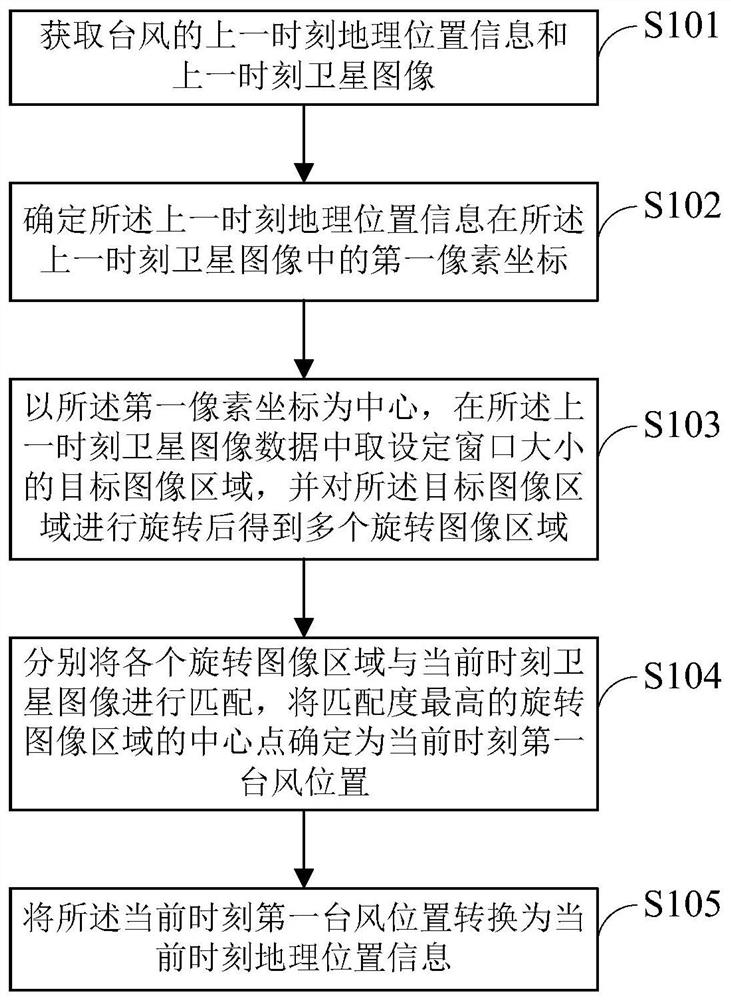
[0087] Such as figure 1 As shown, a flow chart of the typhoon positioning method provided by the embodiment of the present invention may include the following steps:

[0088] Step S101: Obtain the geographical location information and satellite image of the typhoon at the last moment.

[0089] In typhoon positioning, in order to avoid the problem of large errors when only using satellite images for typhoon positioning, you can combine the meteorological data released by the meteorological station for multi-data source typhoon positioning. The meteorological data can be typhoon messages, and the typhoon messages can record history. Typhoon location such as historical typhoon latitude and longitude information, forecast typhoon location such as forecast typhoon latitude and longitude information, typhoon moving speed, typhoon intensity information, etc. It should be noted that the embodiment of the present invention is not limited to the specific content of the meteorological d...

Embodiment 2

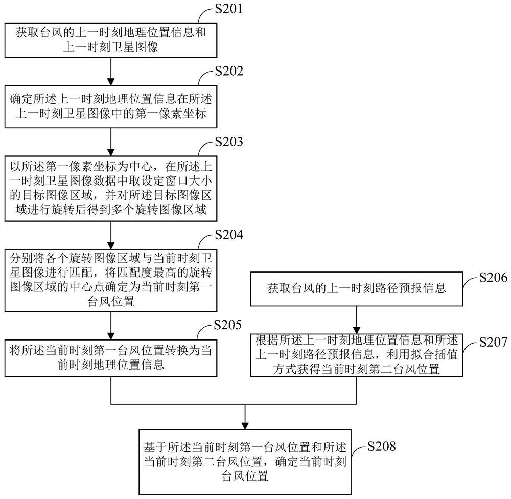
[0099] Such as figure 2 As shown, another flow chart of the typhoon positioning method provided by the embodiment of the present invention may include the following steps:

[0100] Step S201: Obtain the geographical location information and satellite image of the typhoon at the last moment.

[0101] Step S202: Determine the first pixel coordinates of the geographical position information at the last moment in the satellite image at the last moment.

[0102] Step S203: taking the first pixel coordinate as the center, taking a target image area with a set window size from the satellite image data at the last moment, and rotating the target image area to obtain a plurality of rotated image areas.

[0103] Step S204: Match each rotating image area with the satellite image at the current moment, and determine the center point of the rotating image area with the highest matching degree as the position of the first typhoon at the current moment.

[0104] Step S205: converting the ...

Embodiment 3

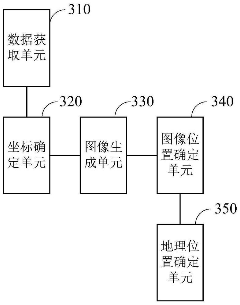
[0125] Such as image 3 As shown, a structural diagram of a typhoon positioning device is provided for the present invention, including: a data acquisition unit 310 , a coordinate determination unit 320 , an image generation unit 330 , an image position determination unit 340 and a geographic location determination unit 350 .

[0126] Wherein, the data acquisition unit 310 is used to acquire the geographical location information and the satellite image of the typhoon at the last moment;

[0127] A coordinate determining unit 320, configured to determine the first pixel coordinates of the geographical location information at the previous moment in the satellite image at the previous moment;

[0128] The image generating unit 330 is configured to take the first pixel coordinates as the center, take a target image area with a set window size in the satellite image data at the last moment, and rotate the target image area to obtain a plurality of rotate the image area;

[0129] ...


PUM


Abstract

The invention discloses a typhoon positioning method, device and system, electronic equipment and a storage medium. The typhoon positioning method comprises the following steps of: acquiring previous moment geographic position information and a previous moment satellite image of a typhoon; determining first pixel coordinates of the previous moment geographic position information in the previous moment satellite image; taking the first pixel coordinates as a center, taking a target image area with a set window size from the previous moment satellite image data, and rotating the target image area to obtain a plurality of rotating image areas; respectively matching each rotating image area with a current moment satellite image, and determining the central point of the rotating image area with the highest matching degree as a current moment first typhoon position; and converting the current moment first typhoon position into current moment geographical position information. According to the typhoon positioning method, multiple data sources are adopted, the problem that errors are large when typhoon positioning is conducted only through satellite images is avoided through adopting a multi-source weighted fusion algorithm and a distance attenuation algorithm, and the calculated typhoon path is smoother and more stable.

Description

technical field [0001] The invention relates to the technical field of meteorological detection, in particular to a typhoon positioning method, device, system, electronic equipment and storage medium. Background technique [0002] Typhoons are powerful and extremely destructive. The positioning technology of typhoons is related to many matters such as meteorological security and emergency avoidance. A typhoon positioning method based on satellite remote sensing is provided in the prior art, using message information and satellite images of the Global Communications System for positioning tasks, and the method obtains T from the messages of the Global Communications System n-1 Time typhoon positioning information, and then match the corresponding time (ie T n-1 Time) satellite imagery, so as to obtain T n-1 The relative position of the typhoon on the satellite image at any time, according to this information combined with the current time (i.e. T n moment) image, and then ...

Claims


Application Information

Patent Timeline
IPC IPC(8): G06T7/73G01W1/00
CPCG06T7/73G01W1/00G06T2207/10032Y02A50/00
Inventor 张天虎郑昕
Owner 象辑科技股份有限公司
Why Eureka
Try Eureka