Urban low-altitude unmanned aerial vehicle path planning method considering safety risk and noise influence
A safety risk and noise impact technology, applied in complex mathematical calculations, navigation calculation tools, design optimization/simulation, etc., can solve the problems of small safety risks, less research on UAV path planning, etc., and achieve the effect of small noise impact
- Summary
- Abstract
- Description
- Claims
- Application Information
AI Technical Summary
Problems solved by technology
Method used
Image
Examples
Embodiment Construction
[0095] In order to facilitate the understanding of those skilled in the art, the present invention will be further described below in conjunction with the embodiments and accompanying drawings, and the contents mentioned in the embodiments are not intended to limit the present invention.
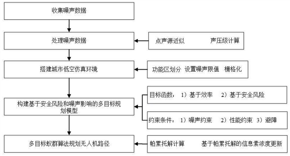
[0096] refer to figure 1 As shown, a kind of urban low-altitude unmanned aerial vehicle route planning method that considers safety risk and noise impact of the present invention, the steps are as follows:
[0097] (1) Collect the noise experiment data at a specific flying height of the UAV, and select the noise experiment data with strong stability as the original data;
[0098] In the example, the 69dB sound pressure level measured at a flying height of 10m is collected as the original noise data.
[0099] (2) The UAV noise source is approximated as a point sound source; according to the non-directional point sound source geometric divergence attenuation formula, use the original data in ...
PUM
 Abstract
Description
Claims
Application Information
 - R&D
- Intellectual Property
- Life Sciences
- Materials
- Tech Scout
- Unparalleled Data Quality
- Higher Quality Content
- 60% Fewer Hallucinations
Browse by: Latest US Patents, China's latest patents, Technical Efficacy Thesaurus, Application Domain, Technology Topic, Popular Technical Reports.
© 2025 PatSnap. All rights reserved.Legal|Privacy policy|Modern Slavery Act Transparency Statement|Sitemap|About US| Contact US: help@patsnap.com


