
Map reconstruction fusion method based on laser and microwave cooperation

A technology of map reconstruction and fusion method, which is applied in the field of map surveying and mapping, can solve the problem of map construction in areas that cannot be blocked, and achieve the effect of improving the drawing ability

Pending Publication Date: 2021-12-03
UNIV OF ELECTRONIC SCI & TECH OF CHINA
View PDF0 Cites 0 Cited by
  • Summary
  • Abstract
  • Description
  • Claims
  • Application Information

AI Technical Summary

Problems solved by technology

However, all lidar-based map reconstruction methods can only be limited to the results of lidar perception within the line-of-sight range, and cannot map occluded areas at the same time

Method used


Image

  • Map reconstruction fusion method based on laser and microwave cooperation
  • Map reconstruction fusion method based on laser and microwave cooperation
  • Map reconstruction fusion method based on laser and microwave cooperation

Examples


Embodiment Construction

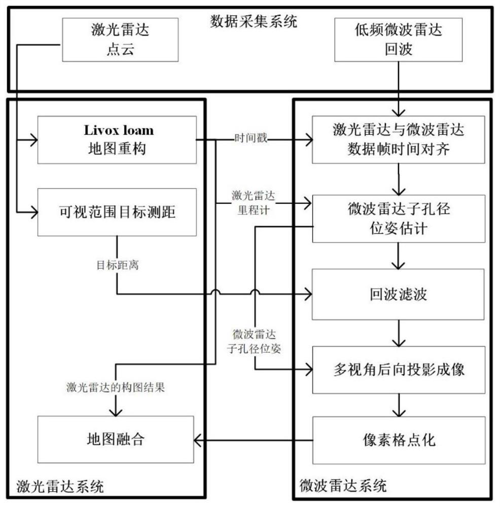
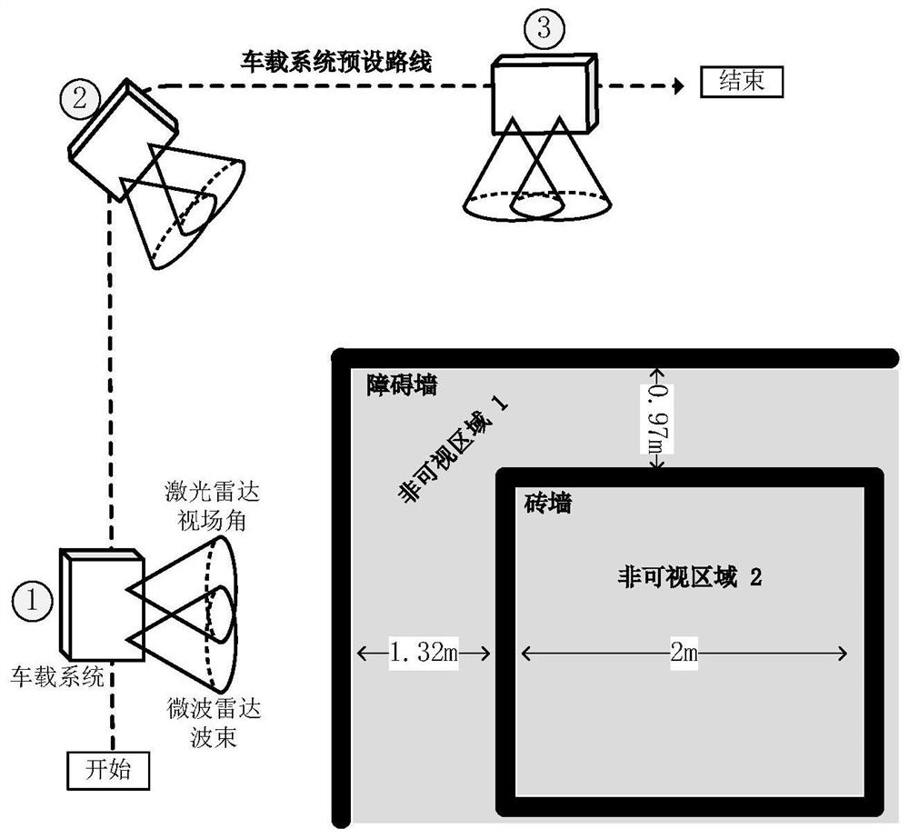
[0035] The algorithm flow of the present invention is as figure 1 shown. The following is based on figure 2 The experimental scene built provides a specific implementation of the present invention: the vehicle-mounted system is equipped with laser radar and microwave radar and travels according to the preset route (dotted line). Due to the occlusion of the wooden wall, the brick wall is in the blind spot when the vehicle-mounted system is moving.

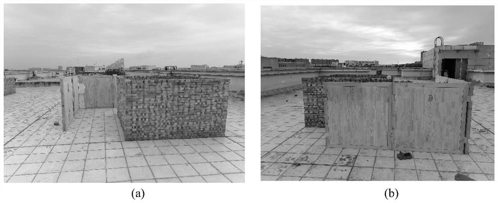
[0036] The optical image of the experimental scene such as image 3 shown. in-vehicle systems such as Figure 4 As shown, the laser radar and the microwave radar are fixed on the vehicle system and face the right side of the car body uniformly. The microwave radar is mounted on the guide rail that can move up and down. 3D result graph. There is always a 90-degree difference between the traveling route of the car and the radar orientation. The vehicle-mounted system in the present invention includes a walkable car, and a data p...


PUM


Abstract

The invention discloses a map reconstruction fusion method based on laser and microwave cooperation, which is applied to the field of three-dimensional high-precision map surveying and mapping with a shielded area, and aims to solve the problems that the sensing range of the existing surveying and mapping scheme adopting the combination of a camera, a laser radar, a millimeter-wave radar and the like is only limited to a sight distance area, and information in a shielding environment cannot be obtained. The method adopted by the invention comprises the following steps: firstly, synchronously acquiring point cloud data of the laser radar and echo data of a microwave radar, acquiring laser radar pose parameters in a feature point matching mode according to the point cloud data of adjacent frames, and reconstructing a scene map; and then estimating the poses of sub-apertures distributed in the moving process of the microwave radar by using the laser radar pose parameters, filtering the echo data of the microwave radar by taking the sub-aperture poses and the visual range object distance estimated by the laser radar as reference to obtain a microwave radar imaging result map, and fusing imaging results to obtain a map mapping result of the visible and shielded areas.

Description

technical field [0001] The invention belongs to the field of map surveying and mapping, and in particular relates to a three-dimensional high-precision map surveying technology with blind areas of vision. Background technique [0002] High-precision 3D map surveying is of great significance in areas such as autonomous driving, forest resources survey, and urban building reconstruction. Lidar plays a key role in map reconstruction because it can provide high-precision environment perception information with small errors. [0003] There are two main types of map reconstruction methods for lidar. The first type is based on full point cloud matching, and the second type is based on feature point cloud matching. In the first type, the iterative closest point method (ICP) is the most representative (P.J.Besl and N.D.McKay, “Amethod for registration of 3-D shapes,” IEEE Transactions on Pattern Analysis and Machine Intelligence, vol.14, no. 2, pp.239-256, Feb.1992.): It estimates...

Claims


Application Information

Patent Timeline
IPC IPC(8): G06T17/05
CPCG06T17/05Y02T10/40
Inventor 郭世盛资引东陈家辉许振昌崔国龙孔令讲杨晓波
Owner UNIV OF ELECTRONIC SCI & TECH OF CHINA
Learn More