A low-power, low-cost, high-precision navigation satellite surface deformation monitoring system

A technology for navigation satellites and surface deformation, which is applied in satellite radio beacon positioning systems, radio wave measurement systems, and electrical/magnetic solid deformation measurement, etc. Strong and comprehensive effect

Active Publication Date: 2022-03-01
NANJING HYDRAULIC RES INST
View PDF6 Cites 0 Cited by
  • Summary
  • Abstract
  • Description
  • Claims
  • Application Information

AI Technical Summary

Problems solved by technology

[0003] The purpose of the present invention is to provide a low-power, low-cost and high-precision navigation satellite surface deformation monitoring system to solve the problem that the surface deformation of existing bank slopes and mine pits cannot be monitored with high precision

Method used


Image

  • A low-power, low-cost, high-precision navigation satellite surface deformation monitoring system
  • A low-power, low-cost, high-precision navigation satellite surface deformation monitoring system
  • A low-power, low-cost, high-precision navigation satellite surface deformation monitoring system

Examples


Embodiment Construction

[0041] The following will clearly and completely describe the technical solutions in the embodiments of the present invention with reference to the accompanying drawings in the embodiments of the present invention. Obviously, the described embodiments are only some, not all, embodiments of the present invention. Based on the embodiments of the present invention, all other embodiments obtained by persons of ordinary skill in the art without making creative efforts belong to the protection scope of the present invention.

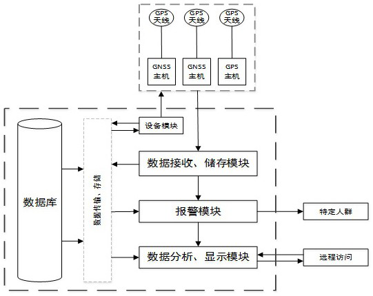
[0042] A low-power, low-cost, high-precision navigation satellite surface deformation monitoring system, such as figure 1 and figure 2 shown, including:

[0043] Cloud server; the cloud server is used to forward base station differential data, receive on-site monitoring data, monitor equipment operating status, automatically analyze and process data, and provide real-time alarms;

[0044] Satellite positioning reference station, the satellite positioning re...


PUM


Abstract

The invention discloses a navigation satellite surface deformation monitoring system with low power consumption, low cost and high precision, and belongs to the technical field of regional surface positioning and monitoring. Cloud server, the cloud server is used to forward base station differential data, receive on-site monitoring data, monitor equipment operation status, automatically analyze and process the data, and provide real-time alarm; satellite positioning reference station, the satellite positioning reference station is used to receive satellite data and transmit the base station differential data to the cloud server in real time; the monitoring point mobile station is used to receive satellite data and download the base station differential data from the cloud server, calculate the fixed position solution and send it to the cloud server; the application is fully Utilize new methods, new instruments, and new technologies for emergency monitoring capacity building, normalize and wide-area river inspection and monitoring, realize comprehensive, systematic, and real-time bank slope deformation data, and at the same time be able to monitor ongoing or imminent occurrences Alarm and encrypted monitoring of the dangerous section of the bank.

Description

technical field [0001] The invention belongs to the technical field of regional surface positioning and monitoring, and in particular relates to a navigation satellite surface deformation monitoring system with low power consumption, low cost and high precision. Background technique [0002] Since the impoundment of the Three Gorges Reservoir, the sediment load in the main stream of the middle and lower reaches of the Yangtze River has dropped sharply, and the erosion of the riverbed has intensified. Long-term discharge of clear water will lead to a very heavy task of river bank collapse management in the middle and lower reaches of the Yangtze River in the future, especially bank collapse is sudden and hidden, and early warning is extremely difficult. At present, the monitoring frequency of early warning and monitoring of river channel bank collapse is insufficient, and the continuity of monitoring data is poor. Insufficient real-time performance and accuracy make it diffic...

Claims


Application Information

Patent Timeline
Patent Type & Authority Patents(China)
IPC IPC(8): G01B7/16G01S19/14
CPCG01B7/16G01S19/14
Inventor 韩玉芳荣建国丁宏伟路川藤陈静王劲龄张功瑾丁伟
Owner NANJING HYDRAULIC RES INST
Why Eureka
Try Eureka