Ground operation and application integrated system for high-resolution remote sensing satellite

A remote sensing satellite and sub-system technology, applied in the field of ground operation and application integration system, can solve the problems of intelligent level of intelligence interpretation, low timeliness and accuracy, limited decision-making support, unreasonable resource allocation, etc., to achieve Manageability and ease of maintenance, improve effectiveness and accuracy, and achieve effective and smooth delivery

Pending Publication Date: 2022-01-04
BEIJING RES INST OF TELEMETRY +1
View PDF0 Cites 2 Cited by
  • Summary
  • Abstract
  • Description
  • Claims
  • Application Information

AI Technical Summary

Problems solved by technology

[0006] The purpose of the present invention is to overcome the above-mentioned problems in the prior art and provide an integrated system of ground operation and application for high-resolution remote sensing satellites. Problems such as poor knowledge transfer and low equipment reuse rate, and at the same time, by establishing a mathematical model of external requirements and resources, automatically resolve resource contention conflicts among various requirements, and solve the problems of low efficiency of task planning and unreasonable resource allocation ;Secondly, new technologies such as artificial intelligence and big data are introduced to solve the problems of intelligence level, timeliness and accuracy of current intelligence interpretation. Finally, information such as surveying and mapping, basic base maps, and ground data are introduced to solve the problem of single forms of current intelligence and poor decision-making. Issues with limited support

Method used


Image

  • Ground operation and application integrated system for high-resolution remote sensing satellite
  • Ground operation and application integrated system for high-resolution remote sensing satellite
  • Ground operation and application integrated system for high-resolution remote sensing satellite

Examples


Embodiment 1

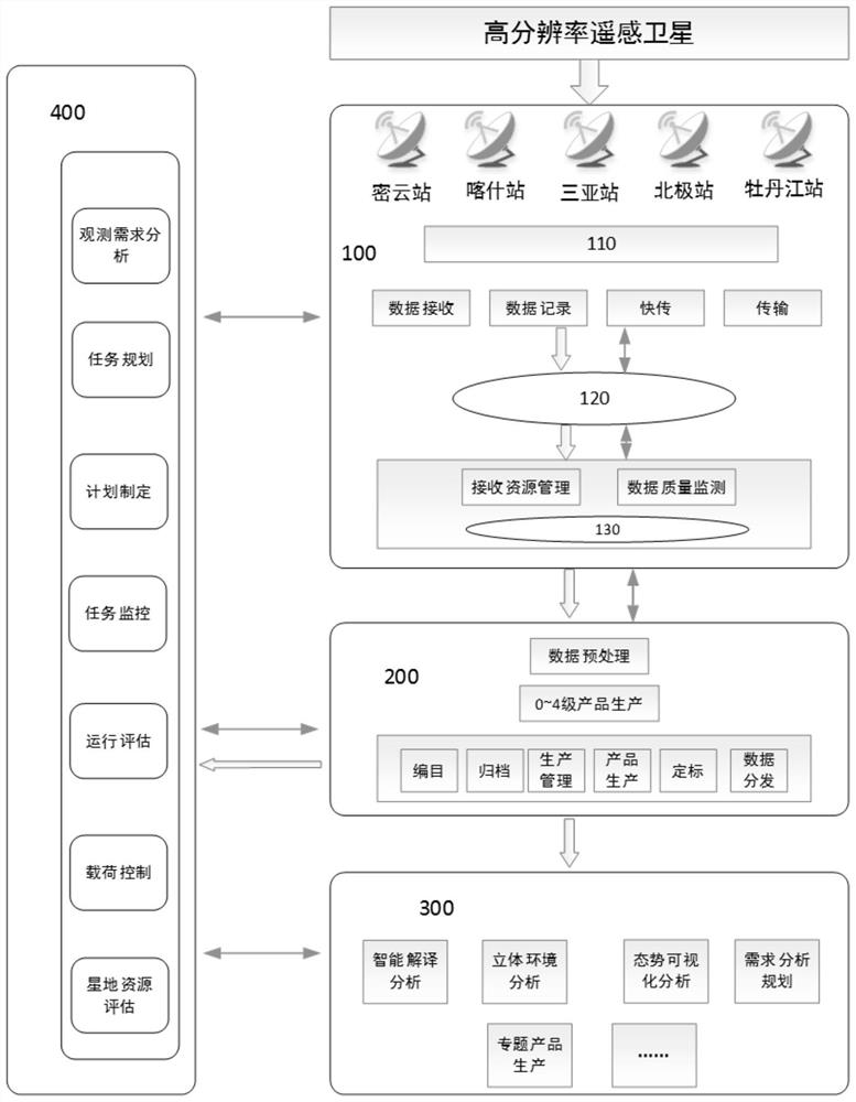
[0072] Such as figure 1 As shown, an integrated system of ground operation and application for high-resolution remote sensing satellites, including:

[0073] Data receiving subsystem 100: used to receive and record satellite payload data while performing receiving resource management and data quality monitoring, and used to transmit satellite payload data to data processing subsystem 200;

[0074] Data processing subsystem 200: used to receive the satellite load data transmitted by the data receiving subsystem 100, perform data processing and generate data products, and then send them to the application service subsystem 300 and users for calibration testing and quality assessment of satellites, using To receive user requirements and forward them to the integrated management subsystem 400, and send data products to the application service subsystem 300;

[0075] Application service subsystem 300: used to receive user requirements transmitted by integrated management subsystem...

Embodiment 2

[0097] An integrated system of ground operation and application for high-resolution remote sensing satellites. The system realizes the interconnection of design, testing, operation and application through process optimization and resource integration, realizes the horizontal transfer of knowledge, and effectively improves satellite design and application. Improve the reuse rate of equipment while improving the level. Secondly, through the integration of internal and external needs and resources, a corresponding decision-making model is established to realize the optimal regulation and allocation of satellite resources, receiving resources, and transmission resources. Then introduce new technologies such as artificial intelligence and big data to effectively improve the timeliness and accuracy of intelligence interpretation. Finally, on the basis of intelligence interpretation, information such as meteorology, hydrology, surveying and mapping, basic base maps, and ground data a...


PUM


Abstract

The invention discloses a ground operation and application integrated system for a high-resolution remote sensing satellite, which is oriented to support high-resolution satellite operation and application. Firstly, a space-ground integrated system integrating design, test, operation control and application of a high-resolution remote sensing satellite is established; interconnection and intercommunication of high-resolution remote sensing satellite design simulation, comprehensive test verification, on-orbit operation management and service data comprehensive application are realized, then an automatic task planning and scheduling strategy is constructed by taking demands as traction, task conflict resolution and optimal planning are realized, a training set of typical targets is established, intelligent target interpretation is achieved based on machine learning, the timeliness and accuracy of target recognition and confirmation are effectively improved, finally data such as meteorology, hydrology, surveying and mapping and a basic map are introduced, target information combined with a three-dimensional environment is constructed, and overall situation awareness of a scene and a target is achieved after visualization.

Description

technical field [0001] The invention relates to the field of operation and application of remote sensing satellites, in particular to an integrated system for ground operation and application of high-resolution remote sensing satellites. Background technique [0002] Remote sensing satellites generally have four stages from design to application: simulation design, comprehensive testing, operation control management, and on-orbit application. The current four stages are independent of each other and cannot be interconnected. On the one hand, the cost is high and the equipment reuse rate is low. On the one hand, there is a lack of knowledge transfer and iteration between stages, and the level of satellite design, development and application is limited. [0003] In addition, the current domestic remote sensing satellites have complex links from the observation requirements to the acquisition of data products, with low efficiency, low level of intelligence, and slow response sp...

Claims


Application Information

Patent Timeline
Patent Type & Authority Applications(China)
IPC IPC(8): G06Q10/06G06K9/62
CPCG06Q10/06395G06Q10/06315G06Q10/06316G06F18/214
Inventor 马晓萌梁健
Owner BEIJING RES INST OF TELEMETRY
Why Eureka
Try Eureka