Karst cave image acquisition monitoring and imaging system

An image acquisition and imaging system technology, applied in surveying and navigation, surveying devices, photogrammetry/video metrology, etc., can solve problems such as insufficient light, poor precision, and incomplete image data

Active Publication Date: 2022-01-11
ZHENGZHOU VOCATIONAL UNIV OF INFORMATION & TECH
View PDF25 Cites 0 Cited by
  • Summary
  • Abstract
  • Description
  • Claims
  • Application Information

AI Technical Summary

Problems solved by technology

For geological disaster scene image transmission, it is currently only focused on realizing video monitoring. However, due to the characteristics of geological disaster monitoring, transmission and power supply problems restrict the application of video monitoring in geological disaster monitoring.
The terrain in the karst caves is peculiar, the geological and geomorphic structure is complex, and there are many stalagmites in the caves that continue to grow and change slowly. The light is insufficient or even dark, and cannot be observed by the naked eye. The workload of regular image collection is heavy, and the different collection locations make it difficult to analyze the data before and after. , the accuracy is poor, and the collected image data is not comprehensive
In the equipment for monitoring, monitoring, recording and alarming of geological disasters in caves, there is basically no application for automatic collection of images and videos. Acquisition and image processing of geological and landform changes in caves provide scientific data support for the study of related geological establishments in karst areas

Method used


Image

  • Karst cave image acquisition monitoring and imaging system
  • Karst cave image acquisition monitoring and imaging system
  • Karst cave image acquisition monitoring and imaging system

Examples


Embodiment 1

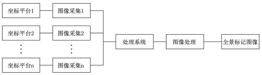
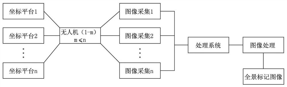
[0030] Embodiment 1: An image acquisition monitoring and imaging system for karst caves, which is used to solve the current problems in caves due to peculiar topography, complex geological and landform structure, poor or no light, and many stalagmites in caves continue to grow slowly and change, which cannot be observed by naked eyes. This leads to the problem that regular image acquisition is heavy or even impossible to achieve. This embodiment adopts asfigure 1 A series of coordinate platforms are arranged at equal intervals on the ground in the cave, and a spherical coordinate system is established with the center of each coordinate platform as the pole in turn, and a binocular camera is arranged at the center of the coordinate platform. However, the image acquisition equipment of a single coordinate platform (can be Including the use of geomorphology instrument host and laser instrument), the adjustment end (the direction of the front lens of the camera and the direction of...

Embodiment 2

[0038] Embodiment 2: On the basis of the system scheme of the embodiment, at each coordinate platform position in the cave, the basic platform is built in advance and installed as Figure 5 As shown in the sealed box 2, a signal emission source is added at each base platform, and an external power supply or an internal storage battery is assembled.

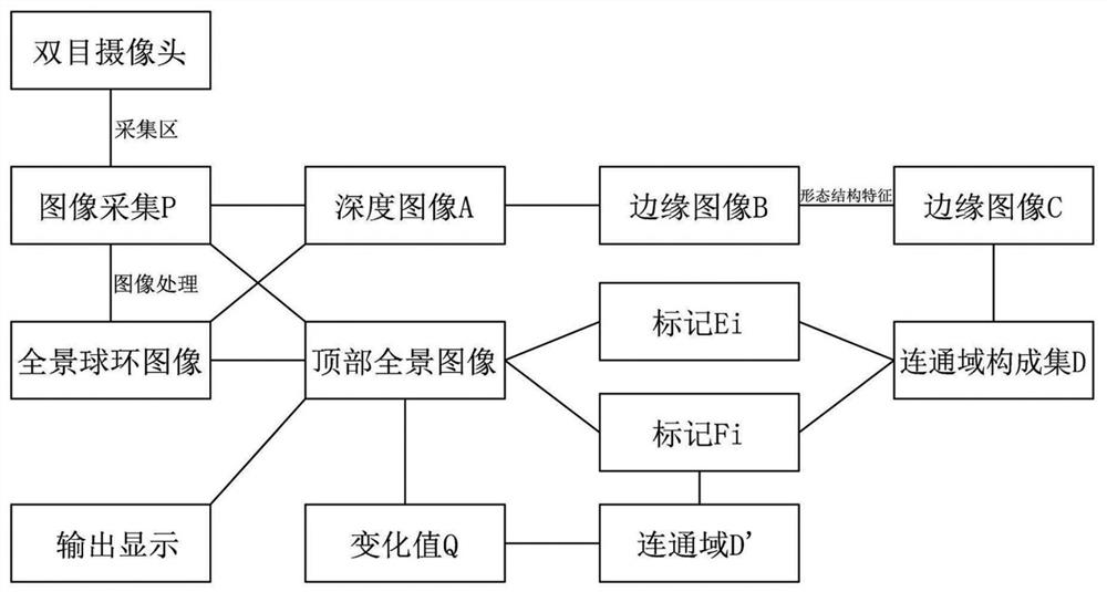
[0039] The binocular camera cloth is directly arranged in the center of the coordinate platform. The binocular camera is composed of a DSL-3079-HE camera and a Sony IMX179 lens. Usually, lasers and / or searchlights that are aligned with the direction of the camera need to be configured on the corresponding coordinate platform to improve Image clarity, accuracy and recognition, a specific layout relationship between coordinate platform 1 and binocular cameras is as follows: Figure 6 and Figure 7 shown. It can be seen that the coordinate platform 1 includes a sealed box 2, a sealed cover 3 and a cover opening and closing mechanis...

Embodiment 3

[0040] Embodiment 3: On the basis of Embodiment 2, each coordinate platform in the cave uses an internal storage battery, which is suitable for areas remote from external power sources. The scale of such caves is scattered and remote, which is not conducive to the introduction of external power sources. Each coordinate platform is equipped with an internal battery respectively. When the storage battery is used as a charging power source, it can be charged by adding solar panels outside the cave.


PUM


Abstract

The invention discloses a karst cave image acquisition monitoring and imaging system, which is characterized in that a series of coordinate sampling platforms are regularly arranged on the ground in a karst cave according to geological and geomorphic characteristics in the karst cave, a spherical polar coordinate system is established by taking the center of each coordinate platform as a pole in sequence, and binocular cameras are arranged at the centers of the coordinate platforms, or adjusting mechanisms which are located on coordinate platforms or an unmanned aerial vehicle and can be adjusted in a rotating and pitching mode are utilized, so that the photographing function and the three-dimensional calibration performance of the binocular cameras are improved, and the distance measuring precision is higher. Through comparison, analysis, adjustment and testing of obtained latest image information and historical image information, an address landform model in the karst cave, the change area and the change measure are output, the temperature, the humidity and other corresponding information are monitored, the functions of dynamic monitoring of geological disasters in the karst cave and regular and continuous monitoring, monitoring and recording of images and videos are achieved, and scientific data support can be provided for research on establishment of related geological models in the karst region.

Description

technical field [0001] The invention belongs to the technical field of image processing and monitoring, and in particular relates to a monitoring and imaging system for geological and landform images in karst caves. Background technique [0002] Image information is one of the most important information obtained by human beings. Image acquisition is widely used in digital image processing, image recognition and other fields. The feasibility, frequency, speed, and quality of image acquisition will directly affect the overall effect of image processing. Due to the complexity of soil erosion phenomena in different geology, reliable methods are often sought to observe and analyze erosion landforms in order to obtain its occurrence mechanism. Currently, image transmission for geological disasters is only focused on realizing video monitoring. However, due to the characteristics of geological disaster monitoring, transmission and power supply problems restrict the application of ...

Claims


Application Information

Patent Timeline
Patent Type & Authority Applications(China)
IPC IPC(8): G01C11/00G01C11/04G01C11/12G01N21/84
CPCG01C11/00G01C11/04G01C11/12G01N21/84Y02T10/70
Inventor 郭红艳谷睿思赵辉赵俊彬张雪
Owner ZHENGZHOU VOCATIONAL UNIV OF INFORMATION & TECH
Why Eureka
Try Eureka