
Spatial analysis method and system based on Beidou grid code and three-dimensional engine

A 3D engine and space analysis technology, applied in the space analysis method and system field based on Beidou grid code and 3D engine, can solve the problem of unacceptable cost consumption and achieve the effect of smooth complexity and difficulty

Pending Publication Date: 2022-02-08
深圳航天智慧城市系统技术研究院有限公司
View PDF0 Cites 5 Cited by
  • Summary
  • Abstract
  • Description
  • Claims
  • Application Information

AI Technical Summary

Problems solved by technology

Create a spatial index for spatial data, and cache strategies for logical structures. The logic of existing data structures can be used to construct new strategies based on business, as well as the consumption of memory and disk space. However, in the face of massive 3D geospatial data, the cost of this solution obviously not acceptable

Method used


Image

  • Spatial analysis method and system based on Beidou grid code and three-dimensional engine
  • Spatial analysis method and system based on Beidou grid code and three-dimensional engine

Examples


Embodiment Construction

[0044] In order to further describe the technical solution of the present invention in detail, this embodiment is implemented on the premise of the technical solution of the present invention, and provides detailed implementation methods and specific steps.

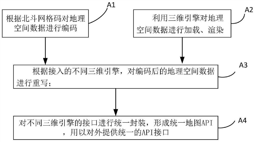
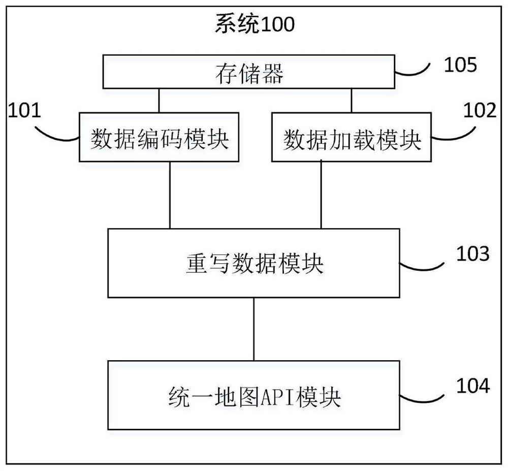
[0045] like figure 1As shown, in the spatial analysis method based on Beidou grid code and 3D engine provided by the embodiment of the present invention, firstly, the 3D geospatial data is lightweight, discretized, Gridding, coded and stored in the warehouse after fusion, effectively providing efficient spatial analysis capabilities, and at the same time directly loading geospatial information data using the large scene rendering of the 3D engine, and providing basic spatial information acquisition such as simple coordinate acquisition etc.; Encapsulate a new spatial analysis interface unified map API interface for data encoded by the 3D engine and Beidou grid code rules, and provide map developers with time-consuming big...


PUM


Abstract

The invention discloses a spatial analysis method and system based on a Beidou grid code and a three-dimensional engine. The method comprises the following steps: encoding geographic spatial data according to the Beidou grid code; loading and rendering the geographic space data by using a three-dimensional engine; according to different accessed three-dimensional engines, rewriting the encoded geographic space data; and uniformly packaging interfaces of different three-dimensional engines to form a uniform map API (Application Program Interface) for externally providing a uniform API interface. According to the method, the Beidou grid code technology is utilized, the three-dimensional geographic space data is lightened, discretized and gridded, meanwhile, efficient association and integration of the three-dimensional data and the space sensing data are achieved on the basis of grid coding, the calculation efficiency of the massive three-dimensional geographic space data can be multiplied, and meanwhile, consumption of redundant memory and disk space is avoided.

Description

technical field [0001] This application relates to the field of spatial analysis, in particular to a method and system for spatial analysis based on Beidou grid code and 3D engine. Background technique [0002] In recent years, with the rise of the wave of smart city construction, spatial information has become the core and foundation of smart city construction due to its important characteristics of time and space, and geospatial information and visualization have played an increasingly important role in it. The software engine of the 3D geographic information platform serves the construction of digital cities. It has a comprehensive geometric model of geographic features, can easily manage multiple types of large-scale geographic feature data, and provides accurate spatial analysis and computing capabilities. However, in the spatial analysis of massive data, the spatial retrieval, analysis, and calculation capabilities provided by the engine are all vector matrices compose...

Claims


Application Information

Patent Timeline
IPC IPC(8): G06T19/20G06T15/00G06T17/05
CPCG06T19/20G06T15/005G06T17/05
Inventor 陈培成
Owner 深圳航天智慧城市系统技术研究院有限公司
Learn More