Railway engineering environment supervision method based on GIS technology and unmanned aerial vehicle aerial photography

A technology of railway engineering and aerial photography, which is applied in the field of environmental technology management, can solve the problems of backward environmental supervision methods of railway engineering, untimely rectification feedback, and inconspicuous supervision effects, etc., so as to improve the effectiveness of supervision work, obviously advanced, and reduce on-site The effect of work

Pending Publication Date: 2022-02-11
中冶赛迪重庆环境咨询有限公司
View PDF0 Cites 0 Cited by
  • Summary
  • Abstract
  • Description
  • Claims
  • Application Information

AI Technical Summary

Problems solved by technology

[0004] In view of this, the purpose of the present invention is to provide a railway engineering environmental supervision method based on GIS technology and UAV aerial photography, to solve the current railway engineering environmental supervision means backward, supervision effect is not obvious, rectification feedback is not timely and other problems

Method used


Image

  • Railway engineering environment supervision method based on GIS technology and unmanned aerial vehicle aerial photography

Examples


Embodiment Construction

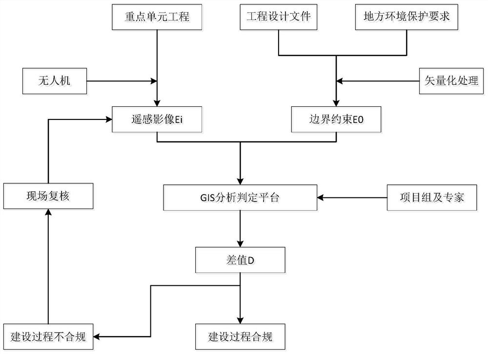
[0026] Embodiments of the present invention are described below through specific examples, and those skilled in the art can easily understand other advantages and effects of the present invention from the content disclosed in this specification. The present invention can also be implemented or applied through other different specific implementation modes, and various modifications or changes can be made to the details in this specification based on different viewpoints and applications without departing from the spirit of the present invention. It should be noted that the diagrams provided in the following embodiments are only schematically illustrating the basic concept of the present invention, and the following embodiments and the features in the embodiments can be combined with each other in the case of no conflict.

[0027] Wherein, the accompanying drawings are for illustrative purposes only, and represent only schematic diagrams, rather than physical drawings, and should...


PUM


Abstract

The invention relates to a railway engineering environment supervision method based on a GIS technology and unmanned aerial vehicle aerial photography, and the method is characterized in that the method comprises the following steps: S1, obtaining a remote sensing image, carrying out the fixed shooting of a key unit project in railway engineering through employing an unmanned aerial vehicle, obtaining the remote sensing image, and building an orthoimage file; s2, boundary constraint setting: collecting engineering design files and local environmental protection requirements, performing vectorization processing through a GIS platform, and setting boundary constraint conditions; s3, performing difference analysis on the remote sensing image in the step S1 and the constraint condition in the step S2 by using a GIS analysis platform, and judging the compliance of the key unit engineering construction process; and S4, according to the analysis and judgment result in the step S3, further verifying the environmental protection problems existing in the engineering construction process of the key unit through field verification, summarizing to form a rectification problem library, and feeding back the rectification problem library to the construction unit and the construction unit.

Description

technical field [0001] The invention belongs to the field of environmental technology management, and relates to a railway engineering environmental supervision method based on GIS technology and unmanned aerial photography. Background technique [0002] The railway project has the characteristics of long line, many construction points, large disturbance area, and large volume of earth and rock taken and discarded, which will inevitably have adverse effects on the ecological environment along the line during construction. In addition, railway projects are generally located in the outskirts of cities, and there are objective factors such as constant traffic and diverse environments, which lead to the untimely arrival of environmental supervision personnel in actual work, and the existing supervision methods are backward, especially for sound barriers, spoil yards, and large slopes. , large-scale temporary projects and other key projects lack timely, effective and accurate sup...

Claims


Application Information

Patent Timeline
Patent Type & Authority Applications(China)
IPC IPC(8): G06Q50/08G06F16/29G01C11/00G06V20/17G06F30/13
CPCG06Q50/08G06F16/29G06F30/13G01C11/00
Inventor 杨军
Owner 中冶赛迪重庆环境咨询有限公司
Why Eureka
Try Eureka