Urban spatial feature region automatic division system

A technology of spatial characteristics and automatic division, applied in special data processing applications, network data browsing optimization, website content management, etc., can solve problems such as processing methods and processes that have not formed a GIS system, and achieve improved search efficiency, convenient use, and expansion strong effect

Pending Publication Date: 2022-02-25
CHONGQING GEOMATICS & REMOTE SENSING CENT
View PDF4 Cites 0 Cited by
  • Summary
  • Abstract
  • Description
  • Claims
  • Application Information

AI Technical Summary

Problems solved by technology

[0005] At present, the main problems in urban zoning: (1) The zoning idea is mainly static, and the static information such as POIs is directly clustered to complete the zoning; (2) Static data such as POIs are first classified, and then the classified POIs are used to (3) cluster the trajectory data, use the cluster center to construct the Voronoi diagram, and complete the partition
Therefore, the partition results under the guidance of the static partition idea have certain limitations
In addition, the grid management mentioned above is more focused on the efficient management of the city, while the division of urban functional areas based on traffic big data is more biased towards the research of algorithms. The processing method and process of GIS system in big cities

Method used


Image

  • Urban spatial feature region automatic division system
  • Urban spatial feature region automatic division system
  • Urban spatial feature region automatic division system

Examples


Embodiment Construction

[0058] The specific implementation manner and working principle of the present invention will be further described in detail below in conjunction with the accompanying drawings.

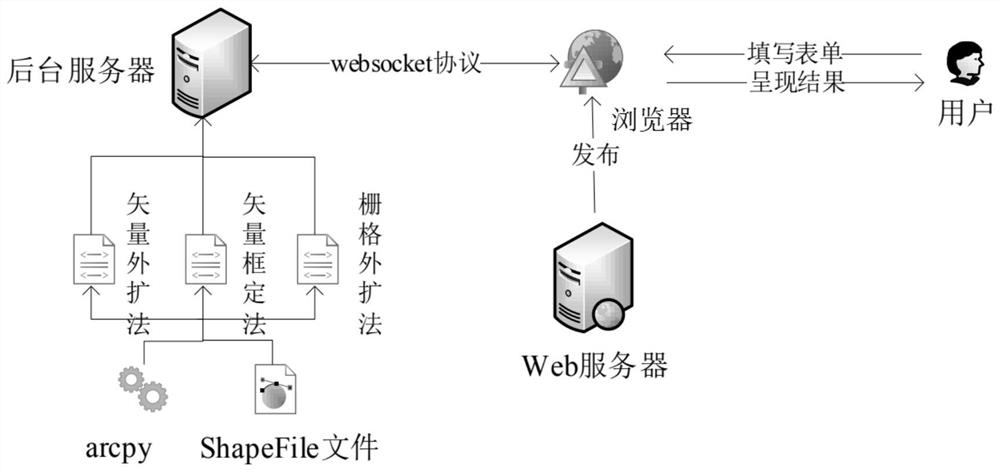
[0059] Such as figure 1 As shown, a system for automatically dividing urban spatial characteristic regions includes a client, a browser, a web server and a background server, and the WebSocket protocol is used for communication between the background server and the browser, wherein:

[0060] The client is used to obtain the content of the form filled by the user;

[0061] The browser is used to splice the content of the form into a long character string and transmit it to the background server as the user clicks the submit button;

[0062] The web server is used to process browser requests and return corresponding responses;

[0063] The background server parses the received character string, then uses the parsed parameters to initialize the constructor of the built-in algorithm, and performs geogr...


PUM


Abstract

The invention discloses an urban spatial feature region automatic division system, which comprises: a user side used for acquiring form content filled by a user; the browser that is used for splicing form contents into a long character string and transmitting the long character string to the background server along with clicking of a submission button by a user; the network server that is used for processing the request of the browser and returning a corresponding response; the background server that analyzes the received character string and executes geographical calculation in the background; after calculation is completed, the position and the file name of the generated ShapeFile compressed file are transmitted to a browser; and the browser analyzes the received data, converts a ShapeFile compressed file into a GeoJson format, and superposes a result calculated by the background server on a base map of a map on the right side of a browser page for display. The invention has the remarkable effects that a plurality of region division algorithms are designed, results can be compared, and an algorithm which is more suitable for actual region division is selected.

Description

technical field [0001] The invention relates to the technical field of urban geographical management, in particular to an automatic division system for urban spatial characteristic areas. Background technique [0002] With the continuous increase of the urban population and the continuous expansion of the city scale, more and more areas need to be controlled by the government, and the contradiction between urban planning and urban development has become increasingly prominent. How to improve the quality of urban planning under the new development situation? Planning data at all levels is an important issue facing urban planning. But at present, city managers do not make full use of various urban planning data, and mostly use manual processing, which is inefficient. At the same time, urban geographic information systems have been greatly developed and widely used in recent years. Computer technology, especially Web technology, and corresponding front-end and back-end interac...

Claims


Application Information

Patent Timeline
Patent Type & Authority Applications(China)
IPC IPC(8): G06F16/958G06F16/957G06F16/29
CPCG06F16/958G06F16/9577G06F16/29
Inventor 何小波罗跃金贤锋张海鹏曾攀王馨怡王姝吴迪郝一龙张少佳张洵安丽超蒋雪徐鹏钦彭婧
Owner CHONGQING GEOMATICS & REMOTE SENSING CENT
Why Eureka
Try Eureka