Machine learning multispectral remote sensing image crop straw out-of-field extraction method and system

A multi-spectral image and machine learning technology, applied in the field of multi-spectral satellite remote sensing image data mining, can solve the problems of measurement error, human error of area and progress, and regional positioning control that cannot leave the field, so as to reduce costs and solve efficiency. Low, the effect of preventing illegal burning

Pending Publication Date: 2022-04-15
CHANGGUANG SATELLITE TECH CO LTD
View PDF0 Cites 3 Cited by
  • Summary
  • Abstract
  • Description
  • Claims
  • Application Information

AI Technical Summary

Problems solved by technology

[0007] The present invention solves the problem that there are human errors and measurement errors in the area and progress of straw leaving the field in the existing supervision method, and the problem that it is impossible to realize accurate management and control of the area that has not left the field

Method used


Image

  • Machine learning multispectral remote sensing image crop straw out-of-field extraction method and system
  • Machine learning multispectral remote sensing image crop straw out-of-field extraction method and system
  • Machine learning multispectral remote sensing image crop straw out-of-field extraction method and system

Examples


Embodiment approach 1

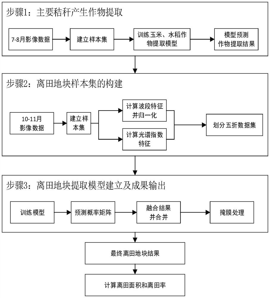
[0044] Embodiment 1. The method for extracting crop stalks from field plots of multi-spectral remote sensing images based on machine learning described in this embodiment, refer to figure 1 This embodiment can be better understood, including the following steps:

[0045] Step S1, obtain the multi-spectral image data of the crop growth period, outline and establish a polygonal sample set according to the crop spectral information, establish a crop classification model, and predict the crop distribution result after the establishment of the crop classification model;

[0046] Step S2, obtaining the multispectral image data after the harvest period of the crops, drawing polygonal samples of the corresponding category, and performing sampling processing to obtain a polygonal sample set of off-field plots;

[0047] Step S3, using the 50% division to divide the polygonal sample set of the field plot, and the obtained five sets of training sets-verification sets are trained as five b...

Embodiment approach 2

[0050]Embodiment 2. This embodiment is a method for extracting crop stalks and field plots from multi-spectral remote sensing images of machine learning described in Embodiment 1. In this embodiment, the multispectral data obtained in the step S1 of the crop growth period In the image data, the multi-spectral image data refers to the wave band as:

[0051] The reflectance data of 10 bands including B2, B3, B4, B5, B6, B7, B8, B8A, B11, and B12, and the multispectral image data format is 16-bit unsigned integer.

[0052] In this embodiment, the reflectance products of 10 bands are selected for the multi-spectral image. The reason is that there are certain differences in the spectral characteristics of the off-field and non-off-field in this band, and the machine learning algorithm used in this method is more sensitive to multi-features. A good effect can automatically reduce the weight of features that do not improve the accuracy of the model. By extracting the features of the...

Embodiment approach 3

[0053] Embodiment 3. This embodiment is a method for extracting crop stalks and field plots from multi-spectral remote sensing images of machine learning described in Embodiment 1. In this embodiment, the steps described in step S1 are to draw and establish polygons based on crop spectral information. sample set,

[0054] The extracted crops include: corn, rice, other crops, and other four types of crops,

[0055] Delineating and establishing a polygonal sample set refers to delineating and establishing 50 to 100 polygonal samples to form a sample set for each category of crops mentioned above.

[0056] In this embodiment, the band feature value of each pixel is extracted according to the sketched sample polygon as a training set.


PUM


Abstract

The invention discloses a multispectral remote sensing image crop straw off-field extraction method and system based on machine learning, and solves the problems that personal errors and measurement errors exist in the off-field area and progress of an existing straw off-field supervision mode, and accurate management and control cannot be realized on non-off-field area positioning. Comprising the following steps: S1, acquiring multispectral image data of a crop growth period, sketching and establishing a polygon sample set according to crop spectral information, establishing a crop classification model, and predicting the established crop classification model to obtain a crop distribution result; s2, acquiring multispectral image data after a crop harvest period, sketching polygonal samples of corresponding categories, and performing sampling treatment to obtain a polygonal sample set of an out-of-field plot; and S3, dividing the polygonal sample set of the out-of-field plot by utilizing five-fold division, training the obtained five groups of training sets-verification sets to obtain five base models, predicting the image data by using the base models, and determining the out-of-field plot through probability mean value fusion of prediction results.

Description

technical field [0001] The invention relates to the technical field of data mining of multi-spectral satellite remote sensing images, in particular to a method and system for extracting off-field plots from multi-spectral remote sensing images of machine learning. Background technique [0002] With the rapid development of agriculture in our country, crop straw treatment has gradually become an important part of agriculture. At present, the treatment of straw is mainly through the way of straw leaving the field. There are two main ways of straw leaving the field. One is to cut the straw short or crush it, spread it evenly on the ground, and then use a high-power tractor to plow or Rotary tillage, to plow it deeply into the soil; the other is to pack and transport the straw directly. The removal of straw from the field can not only reduce the air pollution caused by direct burning of straw, but also realize the recycling of straw, which is of great significance to the protec...

Claims


Application Information

Patent Timeline
Patent Type & Authority Applications(China)
IPC IPC(8): G06V20/13G06V10/764G06K9/62
Inventor 秦磊朱瑞飞马经宇刘思言徐猛彭芝珏周圆锈
Owner CHANGGUANG SATELLITE TECH CO LTD
Why Eureka
Try Eureka