Airport deformation monitoring method of multi-feature scatterer based on amplitude intensity

A technology of amplitude strength and scatterers, which is used in the measurement of electric/magnetic solid deformation, reflection/re-radiation of radio waves, measurement devices, etc. It can solve the problem of high labor and equipment costs, and it is difficult to obtain large-area overall deformation distribution in expansive soil areas. and other problems, to achieve the effect of easy analysis and interpretation, easy and fast acquisition, and improved monitoring accuracy

Pending Publication Date: 2022-04-26
陕西佳维空间地理信息科技有限公司
View PDF0 Cites 1 Cited by
  • Summary
  • Abstract
  • Description
  • Claims
  • Application Information

AI Technical Summary

Problems solved by technology

[0003] At present, there are GNSS measurement, leveling and layered calibration technologies for surface deformation monitoring methods in mountainous airport areas. The above technical solutions can obtain discrete and high-precision point position deformation variables, but due to their high labor and equipment costs, they are affected by terrain factors. It is restricted and difficult to obtain the large-area overall deformation distribution of the expansive soil area, so a high-precision, large-scale, long-period deformation monitoring technology is required

Method used


Image

  • Airport deformation monitoring method of multi-feature scatterer based on amplitude intensity
  • Airport deformation monitoring method of multi-feature scatterer based on amplitude intensity
  • Airport deformation monitoring method of multi-feature scatterer based on amplitude intensity

Examples


Embodiment

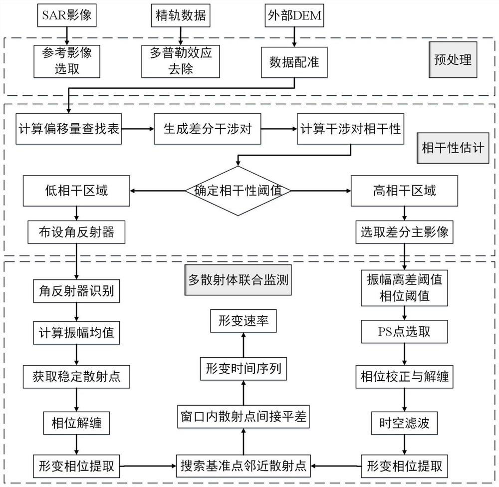
[0078] figure 1 Technical flow chart for the solution of this technical solution

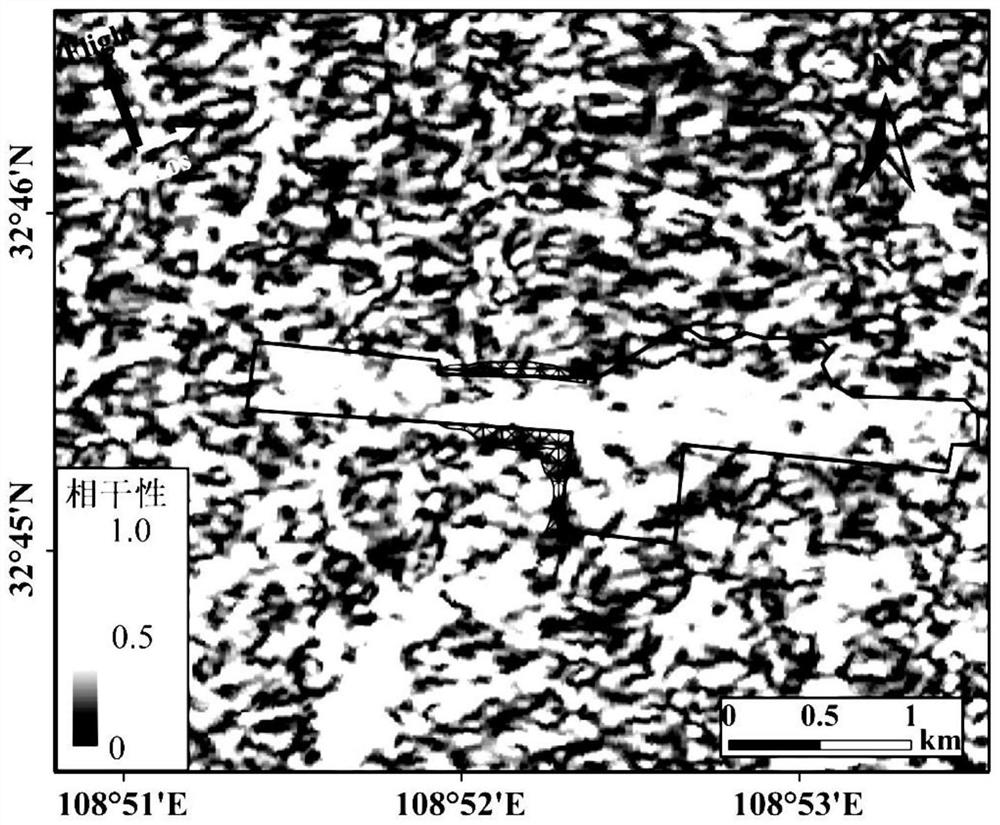
[0079] figure 2 For the coherence coefficient distribution map of this monitoring example (mountainous airport), using SAR (Synthetic Aperture Radar) image data, based on InSAR (Synthetic Aperture Radar Interferometry) to generate differential interference pairs in the study area, and weight the coherence coefficients of the interference pairs Average, to obtain the spatial distribution information of the average coherence coefficient in the monitoring area, and set the coherence coefficient threshold to divide the monitoring area into high and low coherence areas, so as to provide judgment data for the layout of artificial corner reflectors.

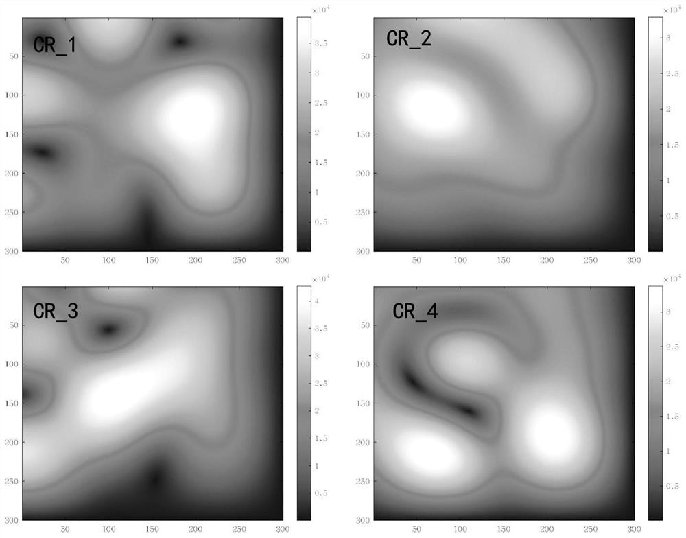
[0080] image 3 For the identification map of the artificial corner reflector in this monitoring example, using SAR (Synthetic Aperture Radar) image data, the precise coordinates are collected according to the manual layout, the position of the artific...


PUM


Abstract

The invention discloses an airport deformation monitoring method for a multi-feature scatterer based on amplitude intensity, and the method comprises the steps: obtaining SAR image data of which space-time baselines meet a threshold value in SAR image data, generating interference pairs, carrying out the coherence estimation of the generated interference pairs, determining a coherence threshold value, dividing a low-coherence region, and carrying out the detection of the low-coherence region. The method comprises the following steps: arranging an artificial corner reflector in a low-coherence area, obtaining a backscattering coefficient amplitude deviation coefficient and an amplitude mean coefficient, taking the amplitude deviation coefficient as a scatterer primary selection threshold value, obtaining a large number of primary selection earth surface scatterers, obtaining deformation information of the primary selection earth surface scatterers, taking the amplitude mean coefficient as a selection threshold value of a correction point, and obtaining the correction point. A certain number of correction points are obtained, networking is carried out on the obtained correction points and the adjacent primarily-selected surface scatterer with similar coherence, indirect adjustment is carried out on the correction points and the primarily-selected surface scatterer, and regional high-precision deformation information is obtained. The method can overcome the influence of regional incoherence on precision, and is high in efficiency and extremely low in cost.

Description

technical field [0001] The invention relates to the technical field of deformation monitoring, and more specifically relates to an airport deformation monitoring method based on amplitude-strength multi-feature scatterers. Background technique [0002] With the implementation and advancement of the "National Comprehensive Three-dimensional Transportation Network Planning Outline", a large number of mountain feeder airports have been built in mountainous areas of our country. Due to the complex geological conditions in mountainous areas, airport deformation monitoring and stability analysis have gradually become hot issues. [0003] At present, there are GNSS measurement, leveling and layered calibration technologies for surface deformation monitoring in mountainous airport areas. The above technical solutions can obtain discrete and high-precision point position deformation variables, but due to their high labor and equipment costs, they are affected by terrain factors. It i...

Claims


Application Information

Patent Timeline
Patent Type & Authority Applications(China)
IPC IPC(8): G01S13/90G01B7/16
CPCG01S13/9021G01B7/16
Inventor 胡兴群张昌波张双成郭衍辉乔明司锦钊周伟李新瑞袁申格任志鹏李乐鑫邓斐周章奇湛肖朱新威
Owner 陕西佳维空间地理信息科技有限公司
Why Eureka
Try Eureka