Multi-process double-linear-array image matching method based on laser elevation control point library

A technology of elevation control point and image matching, applied in the field of satellite laser ranging, can solve the problem of not being able to fully meet the large-scale mapping and other problems, and achieve the effect of facilitating quick query and use, improving the success rate of turning stabs, and improving the speed of search.

Pending Publication Date: 2022-05-13
中国人民解放军61540部队 +1
View PDF0 Cites 0 Cited by
  • Summary
  • Abstract
  • Description
  • Claims
  • Application Information

AI Technical Summary

Problems solved by technology

At present, the principles and methods of using stereoscopic surveying and mapping satellites for global stereographic mapping without ground control points are relatively mature, but they cannot fully meet the requirements of large-scale mapping, and the elevation accuracy is the main constraint factor

Method used


Image

  • Multi-process double-linear-array image matching method based on laser elevation control point library
  • Multi-process double-linear-array image matching method based on laser elevation control point library
  • Multi-process double-linear-array image matching method based on laser elevation control point library

Examples


Embodiment Construction

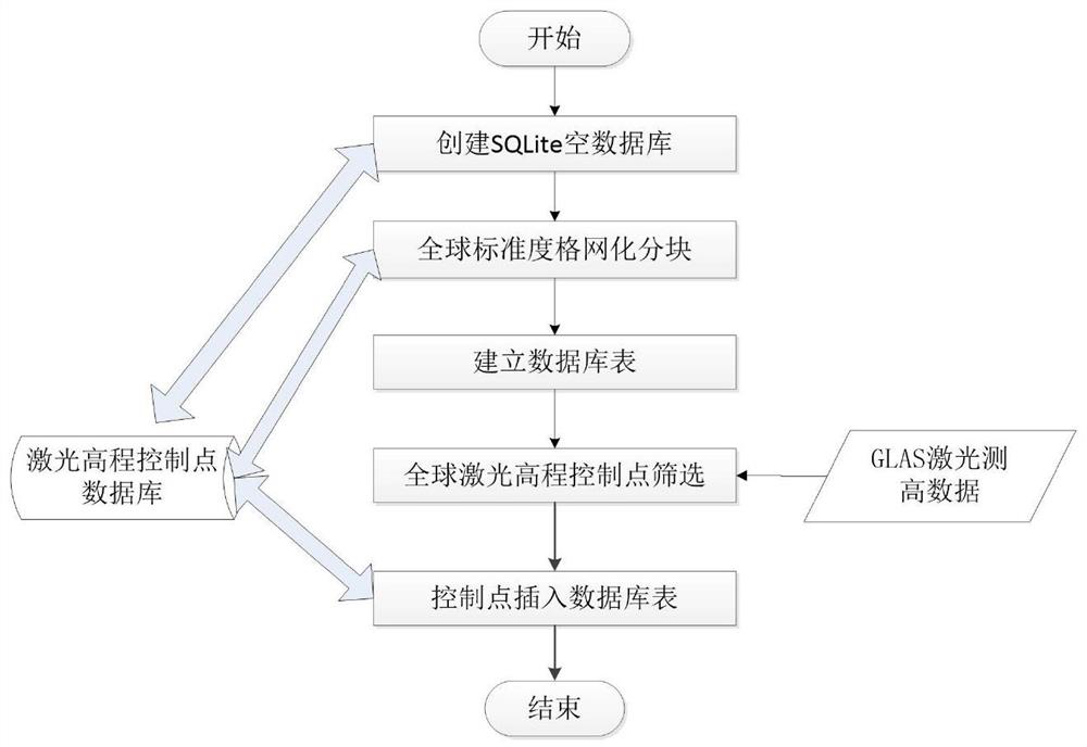
[0045] (1) Construction of laser elevation control point library

[0046] The IceSat (Ice, Cloud, and land Elevation Satellite) Earth observation satellite launched by the United States in 2003 carries the world's first spaceborne laser altimetry system for continuous observation of the Earth, the Geo-science Laser Altimetry System. The satellite in 2003 ~ 2009 to obtain a global range of massive laser altimetry data, many scholars at home and abroad research experiments show that the laser altimetry data obtained by the elevation accuracy of up to 0.15 meters, in the polar ice sheet monitoring, global forest biomass estimation, land elevation measurement and other methods have been widely used. The present invention uses GLASS data as a data source to construct a worldwide database of laser elevation control points.

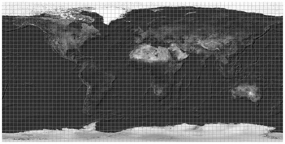
[0047] (1) Global standard degree grid division

[0048]Taking 5 degrees multiplied by 5 degrees as an example, the global (-180~180, -90~90) grid division is unif...


PUM


Abstract

The invention provides a multi-process double-linear-array image matching method based on a laser elevation control point library, and belongs to the field of satellite laser ranging. The method comprises a construction technology of a laser elevation control point library and a double-linear-array image matching technology based on the laser elevation control point library. And constructing a laser elevation control point database by using SQLite. A sub-table storage mechanism and a naming criterion are established when the database is constructed; based on double-linear-array image matching of a laser elevation control point library, a rearview image is partitioned mainly according to a construction mechanism of the laser elevation control point library and an imaging mechanism of double-linear-array images, and a laser elevation control point required by each to-be-processed image is determined by quickly traversing the laser elevation control point database through MPI multiple processes. According to the method, satellite-borne laser altimetry data is used as an elevation control constraint condition to participate in block adjustment calculation of the image, so that the uncontrolled stereo mapping precision of the optical satellite image can be effectively improved, and a large-scale stereo satellite mapping project without a ground control point is realized.

Description

[0001] Field: [0002] A multi-process dual-linear array image matching method based on laser elevation control point library belongs to the field of satellite laser ranging. Background: [0003] Satellite imagery has the advantages of being not limited by national borders, strong periodicity, wide image range, etc., coupled with the continuous improvement of resolution, gradually replacing the previous aerial photogrammetry as an important data source for large-scale mapping production. At present, the principle and method of using stereo mapping satellites to carry out global stereo mapping without ground control points are relatively mature, but they cannot fully meet the requirements of large-scale mapping, of which elevation accuracy is the main constraint. Laser altimetry is an active remote sensing means that can accurately obtain three-dimensional information on the ground, satellite laser altimetry has the ability to actively obtain global surface and target three-dimensio...

Claims


Application Information

Patent Timeline
Patent Type & Authority Applications(China)
IPC IPC(8): G06T3/40G06T5/00G06F16/22G06F16/245G06F16/28G01S17/08G01C5/00
CPCG06T3/4007G06T5/006G06F16/2282G06F16/245G06F16/284G01S17/08G01C5/00G06T2207/20016
Inventor 王建荣胡燕杨秀策张桂滨吕源卢学良杨彦通王一魏永强秦进春
Owner 中国人民解放军61540部队
Why Eureka
Try Eureka