Rapid detection method for SAR image flood inundation area

A detection method and image technology, applied in the directions of image enhancement, image analysis, image data processing, etc., can solve the problems of limited full-polarization SAR data acquisition and inability to meet the requirements of rapid emergency response to disasters, so as to speed up the detection speed and improve The effect of processing efficiency

Pending Publication Date: 2022-05-20
CHINA ELECTRONICS TECH GRP CORP NO 14 RES INST
View PDF0 Cites 0 Cited by
  • Summary
  • Abstract
  • Description
  • Claims
  • Application Information

AI Technical Summary

Problems solved by technology

[0005] In terms of water body information extraction in SAR flood-stricken areas, common methods are based on full-polarization SAR data,

Method used


Image

  • Rapid detection method for SAR image flood inundation area

Examples


Embodiment Construction

[0016] The technical solution of the present invention will be specifically described below in conjunction with the accompanying drawings.

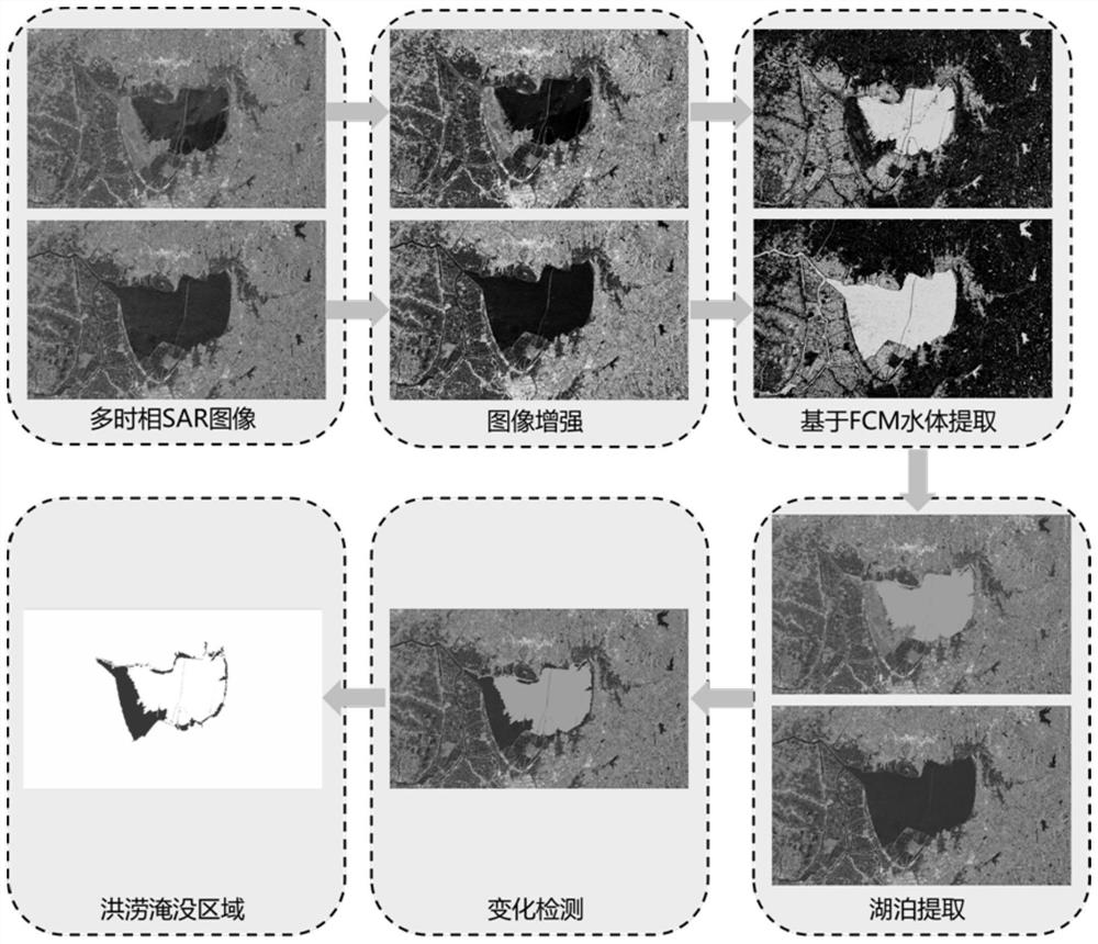
[0017] The procedure of this method is as follows figure 1 Shown:

[0018] Select satellite SAR images in June and July 2020, use image gray histogram equalization to improve the brightness and contrast of SAR images; then use NSCT-based adaptive denoising algorithm to eliminate speckle noise in SAR images , which can preserve the edge information of the image to the greatest extent.

[0019] The edge-preserving gray-scale feature extraction method is used to extract the gray-scale features of the SAR image, and the gray-scale co-occurrence matrix GLCM is used to extract the texture features of the SAR image. Combined with the edge-preserving gray-scale features and texture features, the FCM clustering algorithm is used to segment the SAR image. Obtain preliminary water body extraction results.

[0020] Morphological filtering processi...


PUM


Abstract

The invention discloses a rapid detection method for an SAR image flood inundation area, and aims at the problems of low efficiency and slow response of a traditional flood detection method, the SAR image is enhanced, noise information is removed, gray features and texture features are extracted, a water area of the SAR image is segmented by using an FCM clustering algorithm, and the flood inundation area of the SAR image is obtained. A morphological filtering processing and connected domain analysis method is used to segment an adhesion area of a lake and a river, a length-width ratio and an area threshold value are set, pits and ponds and the river are removed, the lake is reserved, DEM topographic information is used to remove a shadow area generated by a mountain body, false alarm is eliminated, SAR images of two time phases before and after flood are compared, and the method is used to determine whether the flood occurs or not. By using an overlay analysis method and a space overlapping-based block parallel technology, the processing efficiency is improved, the detection speed of a flood inundation area is accelerated, the area, distribution and ground feature type information of the flood inundation area is quickly and accurately obtained, the change of the lake inundation area is detected, and a scientific basis is provided for flood control and disaster relief in time.

Description

technical field [0001] The invention belongs to the technical field of SAR image processing, and in particular relates to a single polarization data processing technology. Background technique [0002] Floods and natural disasters are often accompanied by severe weather, and the monitoring area is affected by clouds and precipitation, making it difficult for optical remote sensing to play a role. As an active microwave imaging sensor, SAR has become the main means of earth observation with its technical advantages of all-day, all-weather, and long-range action. Under severe weather conditions, the remote sensing image information of the monitoring area can be obtained quickly, which provides an important basis for disaster reduction and relief decisions. [0003] "High-precision SAR image water segmentation method based on local super-resolution reconstruction" discloses a medium and low-resolution SAR image water segmentation method based on local super-resolution reconstr...

Claims


Application Information

Patent Timeline
IPC IPC(8): G06V20/13G06T5/00G06T5/40G06T7/11G06T7/187G06T7/62
CPCG06T7/11G06T7/187G06T7/62G06T5/002G06T5/40G06T2207/10044G06T2207/30184
Inventor 谢聪郝明庄龙郑平
Owner CHINA ELECTRONICS TECH GRP CORP NO 14 RES INST
Why Eureka
Try Eureka