

A method and device for unmanned aerial vehicle positioning for search and rescue scenarios
A search and rescue, positioning method technology, applied in the direction of positioning, wireless communication, radio wave measurement system, etc., to avoid the limitation of ground terrain and reduce the cost of hardware
- Summary
- Abstract
- Description
- Claims
- Application Information
AI Technical Summary
Problems solved by technology
Method used
Image

Examples
Embodiment 1
[0038] The invention relates to the field of unmanned aerial vehicles and positioning, in particular to a method and equipment for unmanned aerial vehicle positioning oriented to search and rescue scenarios. The invention utilizes the movement of the unmanned aerial vehicle, combined with the base station ranging and positioning process, and based on the Euclidean geometry theory, realizes the positioning of the rescuers with lower calculation and communication costs.
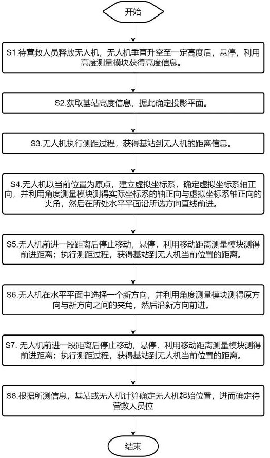
[0039] like figure 1 As shown, the method for locating an unmanned aerial vehicle for a search and rescue scenario according to Embodiment 1 of the present invention includes the following steps.
[0040] S1. After the rescuer releases the drone, the drone lifts vertically to a certain height, hovers, and uses the altitude measurement module to obtain altitude information.
[0041] The hovering altitude of the drone can be the altitude determined by the rescuer through the control device, or the altitude speci...
Embodiment 2
[0063] image 3 It is a schematic structural diagram of the unmanned aerial vehicle equipment oriented to the search and rescue scene of the present invention, including:
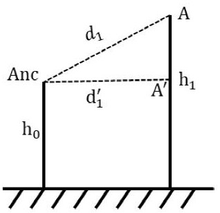
[0064] The altitude measurement module is used to measure the altitude information of the drone and store it in the storage module, so as to determine the projection plane and ensure that it is on the same horizontal plane when moving. It can be based on various methods, for example, the air pressure can be measured by an air pressure sensor, and then the altitude information can be obtained.
[0065] The communication module is connected to the storage module, obtains measurement data from the storage module, communicates and exchanges information with the base station, obtains measurement data such as mutual height information and the final positioning result and stores them in the storage module.
[0066] The ranging module is used to measure the distance between the base station and the UAV and store i...
PUM
 Abstract
Description
Claims
Application Information