
Method for acquiring space-based radio frequency map

A radio frequency map and radiation source technology, applied in the field of radio frequency maps, can solve the problems of small coverage, limited working duration, difficulty in uniform perception, etc., and achieve the effect of long working duration, wide coverage, and uniform perception.

Active Publication Date: 2022-06-28
PLA PEOPLES LIBERATION ARMY OF CHINA STRATEGIC SUPPORT FORCE AEROSPACE ENG UNIV
View PDF15 Cites 0 Cited by
  • Summary
  • Abstract
  • Description
  • Claims
  • Application Information

AI Technical Summary

Problems solved by technology

[0009] 1. The coverage area is small; whether it is multi-sensor throwing or single-point monitoring, it is impossible to locate and perceive radiation sources in a wide range to form a radio frequency map
[0010] 2. The working duration is limited; the sensing sensor needs to process and upload the sensing results in real time, and the built-in battery cannot work for a long time
[0011] 3. It is difficult to evenly sense; affected by the meteorological and environmental factors at the time of throwing, it is difficult for the scattered sensors to be evenly distributed in the area to be sensed
Even if the spatial positions can be evenly distributed, the perceptual sampling is non-uniform due to occlusions such as terrain and buildings.
[0012] 4. Poor concealment; usually the area to be sensed is a hostile or non-cooperative area, and the sensors dropped must cover the key areas where the enemy’s military activities are frequent, and this part of the area is usually heavily guarded, and the deployment of a certain number of sensors has a high risk of being attacked. The risk of discovery, the information uploaded by sensors in such areas is more likely to be intercepted and discovered
[0013] 5. Poor security; if the sensors distributed in the enemy's area are discovered by the enemy, they are likely to be used to form false information, which will adversely affect the implementation of our strategy
[0014] To sum up, the current radio frequency map acquisition methods are mainly based on fixed sensors (single-point or multi-point), some focus on the electromagnetic feature processing of single-point observations of sensors, and some focus on the electromagnetic environment of multi-sensors Inversion and visualization work, currently there is no method to obtain radio frequency maps in a large-scale, uniform, covert, and safe way

Method used


Image

  • Method for acquiring space-based radio frequency map
  • Method for acquiring space-based radio frequency map
  • Method for acquiring space-based radio frequency map

Examples


Embodiment 1

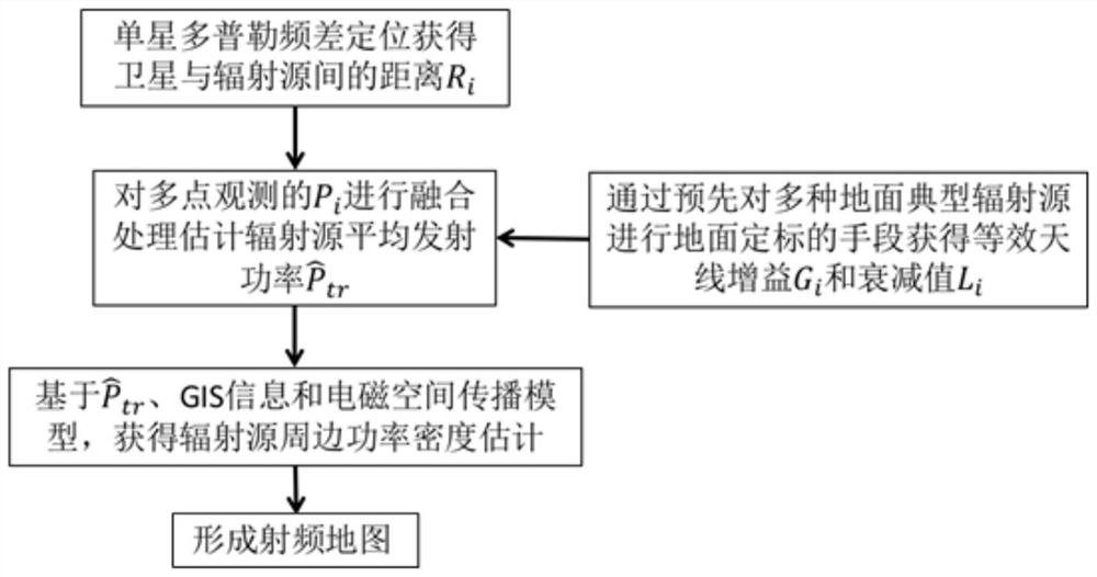
[0044] like figure 2 As shown, in this embodiment, a method for obtaining a space-based radio frequency map is provided, including the following steps,

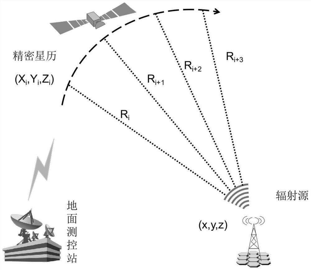
[0045] S1. Obtain the radial distance between the satellite and the radiation source at different times based on the position coordinates of the ground radiation source;

[0046] S2. Based on the radial distance between the satellite and the radiation source, obtain the signal power sampling of the ground radiation source by the satellite at several points in the space orbit;

[0047] S3. Obtain the average transmit power of the radiation source based on signal power sampling;

[0048] S4. Based on the electromagnetic wave prediction model of the mobile communication base station, the power density around the radiation source is obtained by using the average transmission power of the radiation source;

[0049] S5. Obtain a space-based radio frequency map by synthesizing the above relevant data.

[0050] In this embodiment...

Embodiment 2

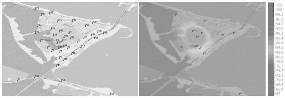
[0074] In this embodiment, taking the surrounding scene of the U.S. military base in Okinawa as an example, the feasibility of the method for obtaining a space-based radio frequency map (RadioMap, RM) is simulated and analyzed.

[0075] The surrounding map of the US military base in Okinawa is as follows Figure 4 As shown, the map accuracy is estimated to be 28.76m (pixel interval) through GIS ruler measurement. Due to the lack of actual data, it is now assumed that there are radiation sources in the U.S. military base and its surrounding cities and villages, and its position is obtained through passive positioning technology of single-satellite Doppler frequency difference.

[0076] Based on the estimation of the average emission power of the radiation source on the multi-point sampling of a single satellite in orbit, and then using the electromagnetic wave prediction model in the standard HJ / T10.2-1996 and the surrounding GIS information, the electromagnetic radiation power...


PUM


Abstract

The invention discloses a method for acquiring a space-based radio frequency map, which comprises the following steps: S1, acquiring radial distances between a satellite and a radiation source at different moments based on position coordinates of a ground radiation source; s2, based on the radial distance between the satellite and the radiation source, acquiring signal power sampling of the satellite on the ground radiation source at a plurality of points of the space orbit; s3, based on signal power sampling, obtaining the average transmitting power of the radiation source; s4, on the basis of the mobile communication base station electromagnetic wave prediction model, obtaining the peripheral power density of the radiation source by using the average emission power of the radiation source; and S5, integrating the related data to obtain the space-based radio frequency map. The method has the advantages that the obtained space-based radio frequency map is wide in coverage range, long in working duration, high in concealment and good in safety.

Description

technical field [0001] The invention relates to the technical field of radio frequency maps, in particular to a method for acquiring space-based radio frequency maps. Background technique [0002] The relevant information of DARPA's "Radio Map" project is published in "Advanced RFMapping program". [0003] The main goal of the project is to "draw" radio frequency maps from the three dimensions of time domain, frequency domain, and air domain to avoid spectrum conflicts and provide soldiers with strong situational awareness. Any form of war is inseparable from a map, and so is the war in the electromagnetic field, but how to draw the map in the electromagnetic field? Figure 1 It's been a big problem. There have been some methods for describing and displaying the electromagnetic spectrum before, such as waterfall diagrams, timing diagrams, etc., but although these methods are full of romanticism at the technical level, ordinary soldiers full of realism do not buy it—what the...

Claims


Application Information

Patent Timeline
IPC IPC(8): H04B17/382H04B17/318H04B7/185G01S5/02
CPCH04B17/382H04B17/318H04B7/1851G01S5/0252
Inventor 唐晓刚陶然李炯郇浩张斌权庄文华高明慧潘协昭任彦洁冯俊豪
Owner PLA PEOPLES LIBERATION ARMY OF CHINA STRATEGIC SUPPORT FORCE AEROSPACE ENG UNIV
Learn More