Cloud base height inversion method based on satellite-borne multi-channel radiation imager

A technology of radiation imaging and cloud base height, applied in altitude/level measurement, instrumentation, mapping and navigation, etc., can solve problems such as limiting cloud base height scientific research and business applications, inversion errors, deviations, etc.

Pending Publication Date: 2022-07-05
NAT UNIV OF DEFENSE TECH
View PDF8 Cites 0 Cited by
  • Summary
  • Abstract
  • Description
  • Claims
  • Application Information

AI Technical Summary

Problems solved by technology

However, actual clouds are diverse and complex, and existing algorithms often have large uncertainties
Using accurate radar detection results to verify, it is also found that the cloud base height inversion results of existing algorithms have large deviations
In addition, since the inversion of the cloud top height and cloud optical parameters of multilayer clouds by the spaceborne multi-channel radiation imager generally has large errors, using existing algorithms to directly invert the cloud base height of multilayer clouds may have a more significant effect. deviation
These shortcomings of existing algorithms limit the scientific research and business application of cloud base height

Method used


Image

  • Cloud base height inversion method based on satellite-borne multi-channel radiation imager
  • Cloud base height inversion method based on satellite-borne multi-channel radiation imager
  • Cloud base height inversion method based on satellite-borne multi-channel radiation imager

Examples


specific Embodiment approach

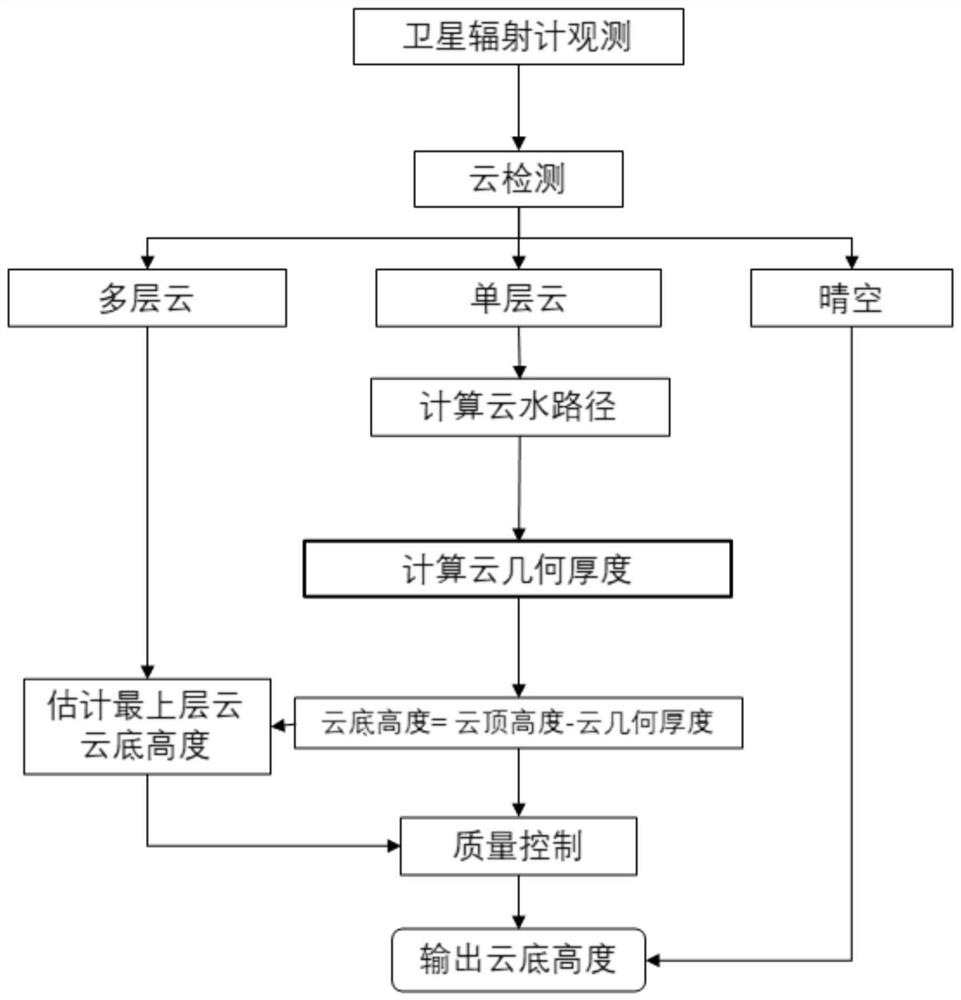
[0044] (1) Establish a multi-layer cloud detection model. The model takes the radiation observation data of the spaceborne multi-channel radiation imager as the main input, and uses the cloud detection model based on random forest to divide the observed pixels into clear sky, single layer cloud and multi-layer cloud. There are three types of clouds. Random forest is the prior art, which will not be repeated in the present invention.

[0045] (2) For a single-layer cloud pixel, the cloud water path CWP is calculated from the cloud optical thickness and the cloud effective particle radius. The specific calculation formula is:

[0046] The object is water cloud: cloud water path = 2 / 3 * cloud optical thickness * cloud effective particle radius;

[0047] The object is ice cloud: cloud water path=0.065*cloud optical thickness^(1 / 0.84);

[0048] (3) Active remote sensing can measure accurate cloud height and cloud thickness, but the spatial coverage is limited. Passive remote sen...


PUM


Abstract

The invention discloses a cloud base height inversion method based on a satellite-borne multi-channel radiation imager. The cloud base height inversion method comprises the following steps: carrying out cloud detection by utilizing observation data of the satellite-borne multi-channel radiation imager; for a single-layer cloud pixel, calculating a cloud water path according to the cloud optical thickness and the cloud effective particle radius; analyzing the relationship between the cloud water path, the cloud top height and the environment factor and the effective cloud water content by using multi-source satellite observation data, and establishing a lookup table of the effective cloud water content; an effective cloud water content estimation value is obtained through the lookup table, and then the cloud water path is divided by the effective cloud water content to obtain the cloud geometric thickness; subtracting the calculated cloud geometric thickness from a known cloud top height inversion result to obtain a cloud bottom height inversion result of the target single-layer cloud; estimating the cloud bottom height of the multilayer cloud by using an extrapolation method; and verifying an inversion result, and optimizing the algorithm. According to the method, better effective cloud water content estimation can be obtained, and the cloud base height can be quickly and effectively inverted; and indirectly inverting the height of the cloud base of the multi-layer cloud by using an extrapolation method.

Description

technical field [0001] The invention belongs to the technical field of atmospheric detection and remote sensing, and in particular relates to a cloud base height inversion method based on a spaceborne multi-channel radiation imager. Background technique [0002] Cloud base height is an important satellite meteorological product, which is widely used in climate change research and aerospace meteorological support. However, at present, domestic Fengyun meteorological satellites do not have cloud base height products based on on-board multi-channel radiation imagers. The spaceborne multi-channel radiation imager measures visible light and infrared radiation from the earth-air system from space, and has the advantages of high spatial and temporal resolution and wide observation and inversion. The radiation measured by the spaceborne multi-channel radiation imager is mainly determined by the cloud top, and cannot directly reflect the information of the cloud base. Therefore, the ...

Claims


Application Information

Patent Timeline
Patent Type & Authority Applications(China)
IPC IPC(8): G01C5/00G01C25/00G06F30/20
CPCG01C5/00G01C25/00G06F30/20
Inventor 谭仲辉马烁严卫胡申森任开军曹小群张卫民赵延来
Owner NAT UNIV OF DEFENSE TECH
Why Eureka
Try Eureka