
Mining tunneling multimode combined positioning method and system

A combined positioning and multi-mode technology, applied in directions such as navigation through speed/acceleration measurement, can solve problems such as difficult application, difficult autonomous and accurate measurement of the position and posture of the cantilever type roadheader, and inability to obtain the position and posture information of the roadheader, etc., to achieve Accurate positioning and solving the effect of irrelevant data

Pending Publication Date: 2022-07-12
中煤华晋集团有限公司 +1
View PDF0 Cites 0 Cited by
  • Summary
  • Abstract
  • Description
  • Claims
  • Application Information

AI Technical Summary

Problems solved by technology

At present, the position and attitude measurement of the cantilever roadheader body is mainly divided into three categories: manual measurement, semi-automatic measurement and autonomous measurement. pose information; the semi-automatic measurement is based on the laser pointing instrument, and the pose parameters of the roadheading machine relative to the laser pointing instrument can be obtained by means of visual measurement or other measurement methods. The positioning of the laser pointing device by personnel has a certain distance from fully automated, unmanned, and intelligent excavation; independent measurement can independently detect the body pose parameters of the cantilever roadheader without relying on external objects, but most of the current The structure of the autonomous measurement system is complex and difficult to apply in actual production
Therefore, relying on a single detection method is difficult to realize the independent and accurate measurement of the position and attitude of the cantilever roadheader. It is the future development trend to propose a multi-mode combined positioning method for mining excavation to realize the independent measurement of the position and attitude of the roadheader.

Method used


Image

  • Mining tunneling multimode combined positioning method and system
  • Mining tunneling multimode combined positioning method and system
  • Mining tunneling multimode combined positioning method and system

Examples


Embodiment 1

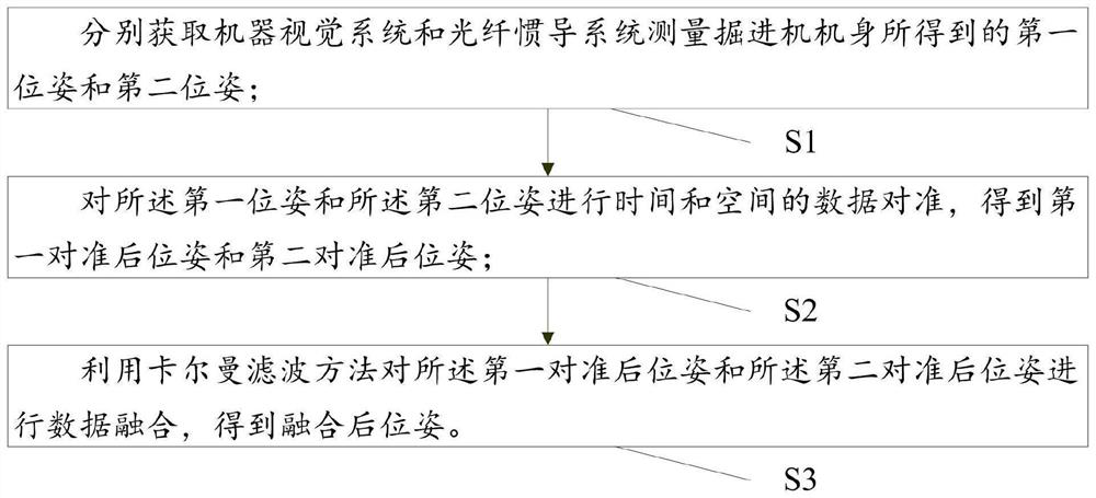
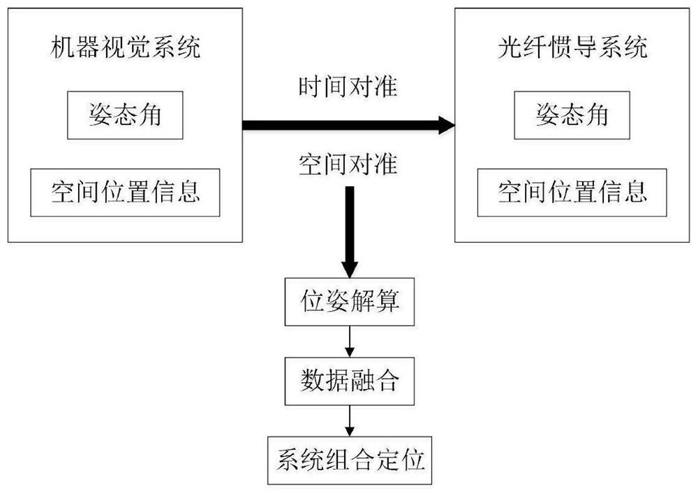
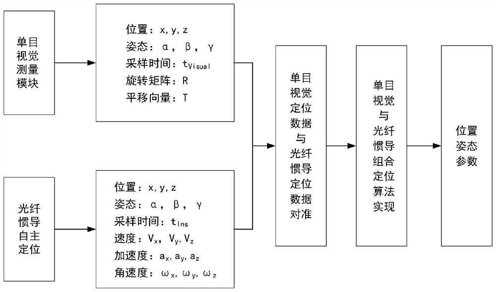
[0029] This embodiment is used to provide a multi-mode combined positioning method for mining tunneling, which is suitable for real-time monitoring of the running state of the tunneling machine in a coal mine, and can obtain the precise running position of the body of the tunneling machine. like figure 1 , figure 2 and image 3 As shown, the combined positioning method includes:

[0030] S1: Obtain the first pose and the second pose obtained by the machine vision system and the fiber optic inertial navigation system to measure the body of the roadheader respectively;

[0031] The machine vision system may be a machine monocular vision measurement system. The first posture includes the body posture information of the roadheader, and the second posture includes the attitude angle and spatial position information of the body posture of the roadheader.

[0032] Specifically, in S1, acquiring the first attitude obtained by the machine vision system measuring the body of the ro...

Embodiment 2

[0152] This embodiment is used to provide a multi-mode combined positioning system for mining excavation, such as Figure 9 As shown, the combined positioning system includes:

[0153] The pose measurement module M1 is used to obtain the first pose and the second pose obtained by the machine vision system and the fiber optic inertial navigation system respectively by measuring the body of the roadheader;

[0154] The data alignment module M2 is used for performing time and space data alignment on the first pose and the second pose to obtain the first aligned pose and the second aligned pose;

[0155] The data fusion module M3 is configured to perform data fusion on the first aligned pose and the second aligned pose by using the Kalman filtering method to obtain the fused pose.


PUM


Abstract

The invention relates to a mining tunneling multimode combined positioning method and system, and belongs to the technical field of mine tunneling equipment positioning. The method comprises the following steps: respectively acquiring a first pose and a second pose obtained by measuring a heading machine body by a machine vision system and an optical fiber inertial navigation system, and then carrying out time and space data alignment on the first pose and the second pose to obtain a first post-alignment pose and a second post-alignment pose; and finally, performing data fusion on the first post-alignment pose and the second post-alignment pose by using a Kalman filtering method to obtain a fused pose, and further accurately positioning the body pose of the heading machine based on fusion of multi-sensor data, so that the problem of data irrelevance is solved, and the positioning of the body of the heading machine is more accurate.

Description

technical field [0001] The invention relates to the technical field of mine excavation equipment positioning, in particular to a multi-mode combined positioning method and system for mining excavation based on multi-sensor data fusion. Background technique [0002] With the unmanned and intelligent development of underground mining in coal mines, solving the problem of autonomous and precise positioning of roadheaders is the core and main task of realizing intelligent and precise mining in coal mines. At present, the body position and posture measurement of the cantilever roadheader is mainly divided into three categories: manual measurement, semi-automatic measurement and autonomous measurement. However, manual measurement is based on the naked eye observation of the construction personnel and the judgment with the help of manual experience, and the roadheader cannot be obtained. The semi-automatic measurement is based on the laser pointer, and the position and attitude par...

Claims


Application Information

Patent Timeline
Patent Type & Authority Applications(China)
IPC IPC(8): G01C21/16
CPCG01C21/1656G01C21/183
Inventor 赵亮尉瑞霍栋王瑞君贺杰张旭辉郭欢欢王曦鞾鹿友磊侯瑞鹏王磊房权刘思程黄瀚
Owner 中煤华晋集团有限公司
Learn More