Automatic assimilation method for multi-source thermal infrared wave band data of polar-orbit meteorological satellite

A meteorological satellite, thermal infrared technology, applied in the field of remote sensing information processing, can solve the problems of multi-source data analysis and application of backward data acquisition and update, data assimilation preprocessing is difficult to do well, etc.

Inactive Publication Date: 2006-06-21
SHANGHAI INST OF TECHNICAL PHYSICS - CHINESE ACAD OF SCI
View PDF0 Cites 9 Cited by
  • Summary
  • Abstract
  • Description
  • Claims
  • Application Information

AI Technical Summary

Problems solved by technology

[0004] Meteorological satellites are a source of information that can be received free of charge, and the data are easy to share. However, the analysis and application o

Method used


Image

  • Automatic assimilation method for multi-source thermal infrared wave band data of polar-orbit meteorological satellite
  • Automatic assimilation method for multi-source thermal infrared wave band data of polar-orbit meteorological satellite
  • Automatic assimilation method for multi-source thermal infrared wave band data of polar-orbit meteorological satellite

Examples


Embodiment Construction

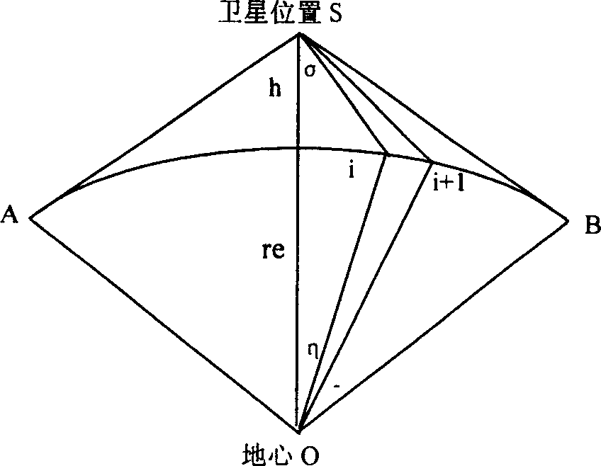
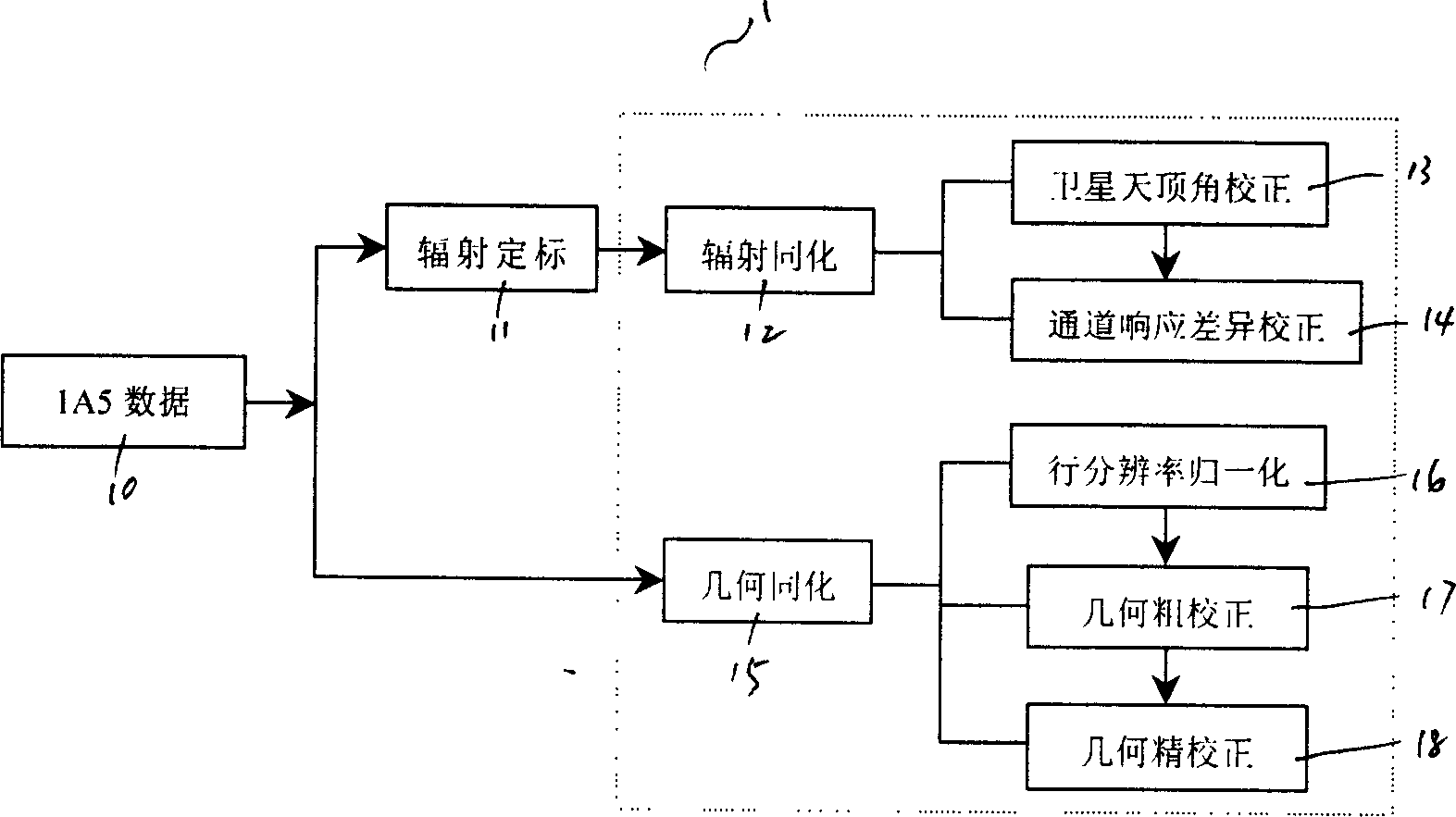
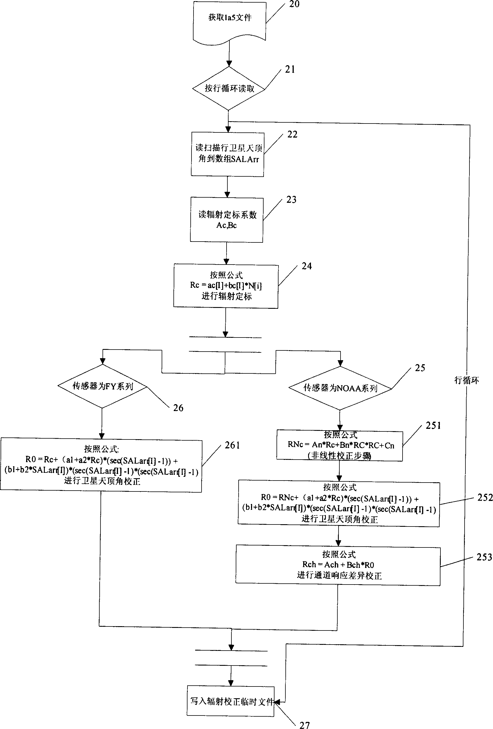
[0068] According to Figure 1-Figure 5 A preferred embodiment of the present invention is given, which is described in detail as follows:

[0069] 1. Select the satellite data used in the example (see figure 2 Step 10 in step 10, after preliminary geometric correction and adding geographic information, the received data is stored in the computer disk in IAS format):

[0070] Taking the Yangtze River Delta region of China as the test area, the meteorological satellite data with better quality is selected according to the signal-to-noise ratio and cloud cover of the test area image. In the example, the Chinese polar-orbiting meteorological satellite FY1D at 7 o'clock on April 1, 2005, the satellite FY1D at 8 o'clock on April 7th, and the US NOAA series meteorological satellite NOAA-17 meteorological satellite data at 10 o'clock on April 8th are selected. , And intercept the sub-area according to the latitude of the test area (28.0746N-33.1446N), but keep the original data column num...


PUM


Abstract

The invention discloses a thermal-infrared band data automatic disposal method of multi-source polar orbit meteorological satellite with radiating assimilation subcourse and geometrical assimilation subcourse, which is characterized by the following: scaling the primitive data by radiation then correcting through satellite zenith angle; finishing radiation assimilation after correcting corresponding channel difference; accomplishing geometrical assimilation through distinguishability normalization, standard space projection transformation and image translation; finishing self-judgment of the same name pixel point through relative matching; reaching direct comparison of different satellite detecting radiation values without artificial operation; improving the precision of geometrical position for multi-source data; paving the base of data disposal and appliance of polar orbit satellite remote sensing data.

Description

Technical field [0001] The invention relates to the field of remote sensing information processing, in particular to a method for automatically completing thermal infrared band data assimilation processing of multi-source orbiting meteorological satellites. Background technique [0002] In many thermal infrared remote sensing applications such as atmospheric and ocean physical phenomenon detection, sudden disaster monitoring (such as earthquakes, volcanic eruptions, forest fires, etc.), pollution source monitoring, etc., it is necessary to quickly update remote sensing images to reflect the "hour" level Change the situation. Polar-orbiting meteorological satellites have many advantages such as strong macroscopicity and short period. Their thermal infrared band data is very suitable for application research in the above-mentioned fields. However, due to the constraints of weather conditions and satellite time factors, relying on a single satellite cannot meet the high-frequency dy...

Claims


Application Information

Patent Timeline
IPC IPC(8): G01S7/48G01S17/89G01S17/95
CPCY02A90/10
Inventor 尹球胡勇祝善友周宁罗庆洲巩彩兰
Owner SHANGHAI INST OF TECHNICAL PHYSICS - CHINESE ACAD OF SCI
Why Eureka
Try Eureka