Intellectual map-matched automobile navigation method based on traffic information

A technology for map matching and vehicle navigation, applied in road network navigators, satellite radio beacon positioning systems, beacon systems using radio waves, etc., can solve problems that map matching technology does not consider, and achieve improved reliability and automatic The effect of the error correction function

Inactive Publication Date: 2006-09-27
赵志弘 +2
View PDF0 Cites 18 Cited by
  • Summary
  • Abstract
  • Description
  • Claims
  • Application Information

AI Technical Summary

Problems solved by technology

Other broader information, such as knowledge of road logic, road traffic restric

Method used


Image

  • Intellectual map-matched automobile navigation method based on traffic information
  • Intellectual map-matched automobile navigation method based on traffic information
  • Intellectual map-matched automobile navigation method based on traffic information

Examples


Embodiment Construction

[0026] The specific implementation manner of the present invention will be described below in conjunction with the accompanying drawings.

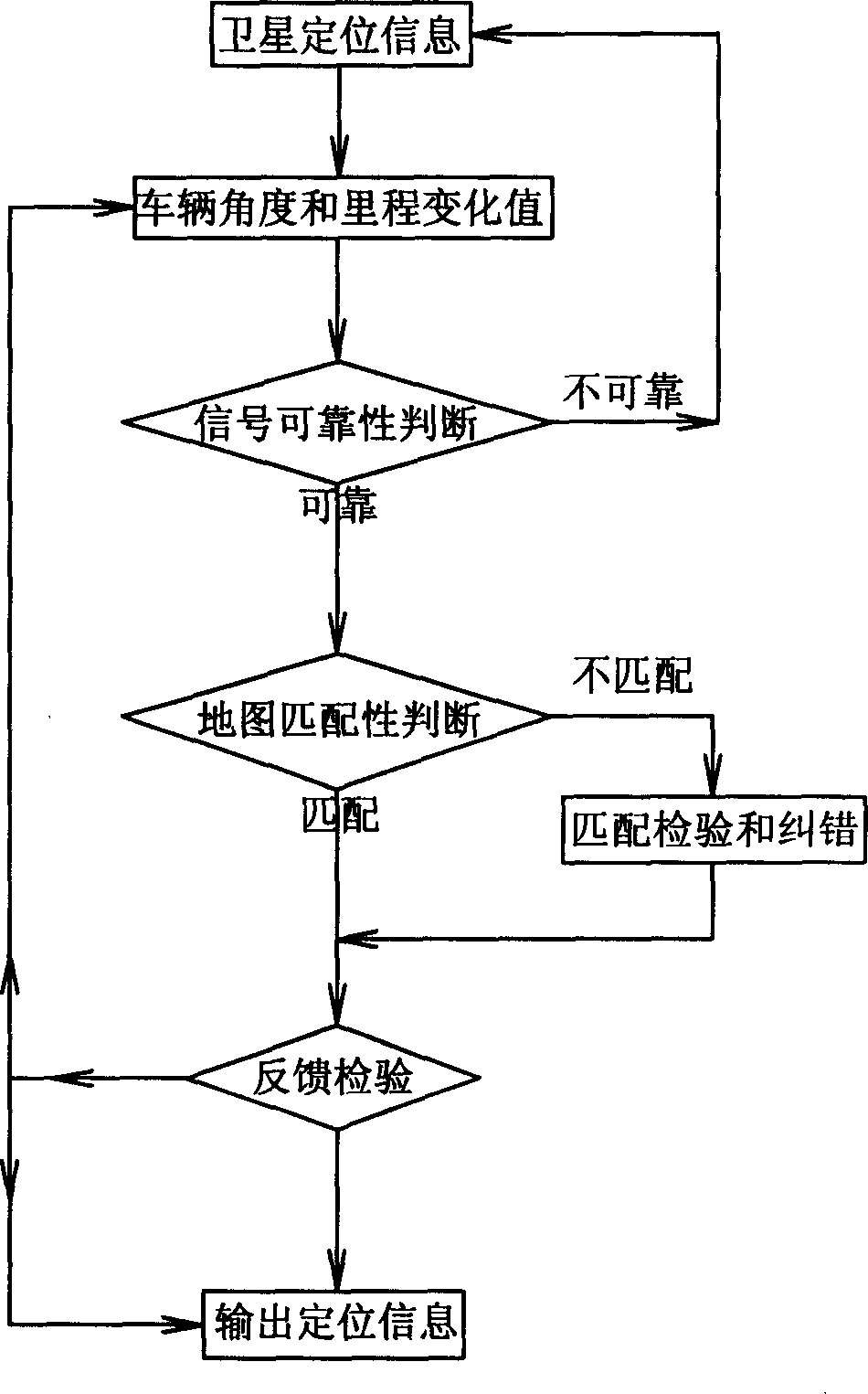
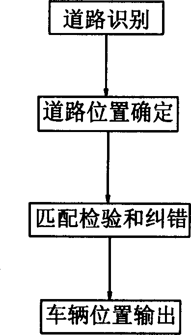
[0027] Such as figure 1 A vehicle navigation method based on intelligent map matching shown in traffic information, the method includes the following steps:

[0028] The vehicle-mounted GPS receiver continuously receives satellite positioning information, while the vehicle-mounted sensor gyroscope receives the data of the vehicle's angle change and mileage;

[0029] According to the GPS quality indicators: signal-to-noise ratio, GDOP, and vehicle driving distance setting range, the reliability analysis of the received satellite positioning information, vehicle angle and mileage data is carried out:

[0030] a. In compliance with the GPS quality index and within the set range of the vehicle's driving distance difference, it indicates that the received information or data is reliable, and outputs satellite positioning information, vehicle a...


PUM


Abstract

This invention relates to an intellectual map-matched automobile navigation method based on traffic information, which comprises continual receiving satellite positioning information by a vehicle-carried GPS receiver, receiving vehicle angle variation and mileage data by vehicle-carried sensor; according to GPS quality index and mileage difference, setting range taking reliability analysis with received data; matching map with E-map to the output positioning information, taking feedback check to received information, and outputting vehicle position. This invention obtains optimal estimation for the vehicle position in road network by combined optimized algorithm, corrects the error from DR system to keep system continual work for a long time without GPS signal, and applies new target-oriented map-matching method to improve match reliability and auto error correction function.

Description

technical field [0001] The invention relates to an intelligent map matching vehicle navigation method based on traffic information. Background technique [0002] In recent years, the GPS-based vehicle integrated navigation system has achieved rapid development, especially the combination of GPS and dead reckoning technology (DR), which makes the vehicle navigation specific and continuous positioning function. When in an air-conditioned area, GPS can provide real-time high-precision vehicle position and correct DR system errors. When the GPS signal cannot be received for a short period of time, the corrected DR system will provide continuous vehicle position. [0003] The high density of urban buildings creates a harsh environment for vehicle positioning because it weakens the satellite signal, which in turn prevents the normal operation of the vehicle positioning system. Map matching technology matches the data of the position sensor with the digital map, and can better ca...

Claims


Application Information

Patent Timeline
IPC IPC(8): G01C21/26G01S1/08G01S5/02G01S19/39
Inventor 赵志弘陈武李志林
Owner 赵志弘
Why Eureka
Try Eureka