System for positioning, navigation, and time (PNT)

a positioning system and positioning technology, applied in direction/deviation determination systems, direction/deviation determining electromagnetic systems, instruments, etc., can solve the problems of not being able to simultaneously lock-on to four direct-path gnss signals in urban environments or environments with large sky obstructions, and need a minimum of four satellite/pseudolite signals, etc., to achieve high-efficiency positioning and positioning, improve the accuracy of positioning, and improve the effect of receiver performan

Active Publication Date: 2020-04-14
TOYON RES CORP
View PDF24 Cites 5 Cited by
  • Summary
  • Abstract
  • Description
  • Claims
  • Application Information

AI Technical Summary

Benefits of technology

[0053]Robotic surgery systems need to precisely measure the location of surgical instruments and internal organs within the human body. The use of AOT-enabled external reference beacons can provide the means to measure the location of a simple, microscopic, RF identification (RFID) tag that is embedded on and along with laparoscopic surgical equipment.
[0054]Radars and VORs used for the national airspace system (NAS) can be upgraded with AOT-enabled transmitters and client receivers to provide improved performance and safety for commercial and military flights across the nation and the globe. Civilian and military aircraft can make use of AOT as well as TOA measurements using simple antennas to estimate their own positions and can transmit that information to the air traffic control system.
[0055]Mobile client receivers in cellular networks can make use of AOT measurements to obtain their positions relative to the cellular network while remaining passive (non-emitting). When combined with TOA / TDOA measurements, the approach can provide highly robust navigation estimates, as well as time.
[0056]WiFi access points can make use of AOT and AOA measurements for self-localization to improve and mitigate receiver performance under multipath environments. Client WiFi receivers can determine their own location relative to the WiFi access points using AOT measurements, as well as the usual information obtained by tracking the coded WiFi signal. Furthermore, in light of the newer multi-input multi-output (MIMO) communication systems, AOT measurements can be naturally obtained from the multiple input measurements.
[0057]In short, any system that requires precise positioning or navigation, with or without GNSS signals, or with partial-GNSS signals, can also make use of AOT measurements for improved performance. Some novel advantages of the exemplary embodiments of the navigation reference system are:
[0058]A client receiver can measure the elevation and azimuth angle of the 2-D angle-of-transmission of each reference signal impinging on the client antenna, as well as its time-of-arrival without requiring a direction-finding antenna;

Problems solved by technology

A significant drawback of GNSS-based PNT systems is that a minimum of four satellite / pseudolite signals are needed for 3-D positioning, and even more are needed if precise positioning is required.
In addition, it isn't often always possible to simultaneously lock-on to four direct-path GNSS signals in urban environments or environments with large sky obstructions, including hills and mountains.
Furthermore, client navigation systems that make use of direction-finding (DF) techniques and DOA / AOA measurements require sophisticated antennas and receivers with two or more feeds, which increase the cost and complexity of the client receiver navigation system.
Another drawback of GNSS systems is that because of their weak signal strength, they can be intentionally and unintentionally jammed or denied.
A shortcoming of the VOR system includes the fact that even if multiple VOR systems were used, they could only provide a 2-D navigation solution for aircraft.
Furthermore, the VOR approach requires a rotating antenna pattern that cannot provide simultaneous (always-on) coverage for the entire sky.
Hence, the measurement update rate of the system, and therefore, the performance of the system, is limited.
Finally, the VOR system doesn't provide a time-of-arrival or a time difference-of-arrival measurement, which implies that a client aircraft cannot determine its own 3-D position and time by relying solely on VOR measurements.
DME also requires RF transmissions by the client receiver, which is not always feasible or permitted for military and sometimes even civilian applications.
In addition, neither LORAN nor VOR / DME is sufficiently accurate for precision (meter- or centimeter-level) navigation that is required for some applications.
Moreover, unlike GNSS-based systems, which require four satellites / pseudolites, the system described herein only requires two transmitters to provide a full 3-D position and time solution.

Method used


Image

  • System for positioning, navigation, and time (PNT)
  • System for positioning, navigation, and time (PNT)
  • System for positioning, navigation, and time (PNT)

Examples


Embodiment Construction

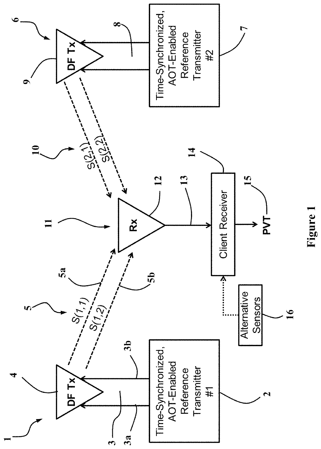
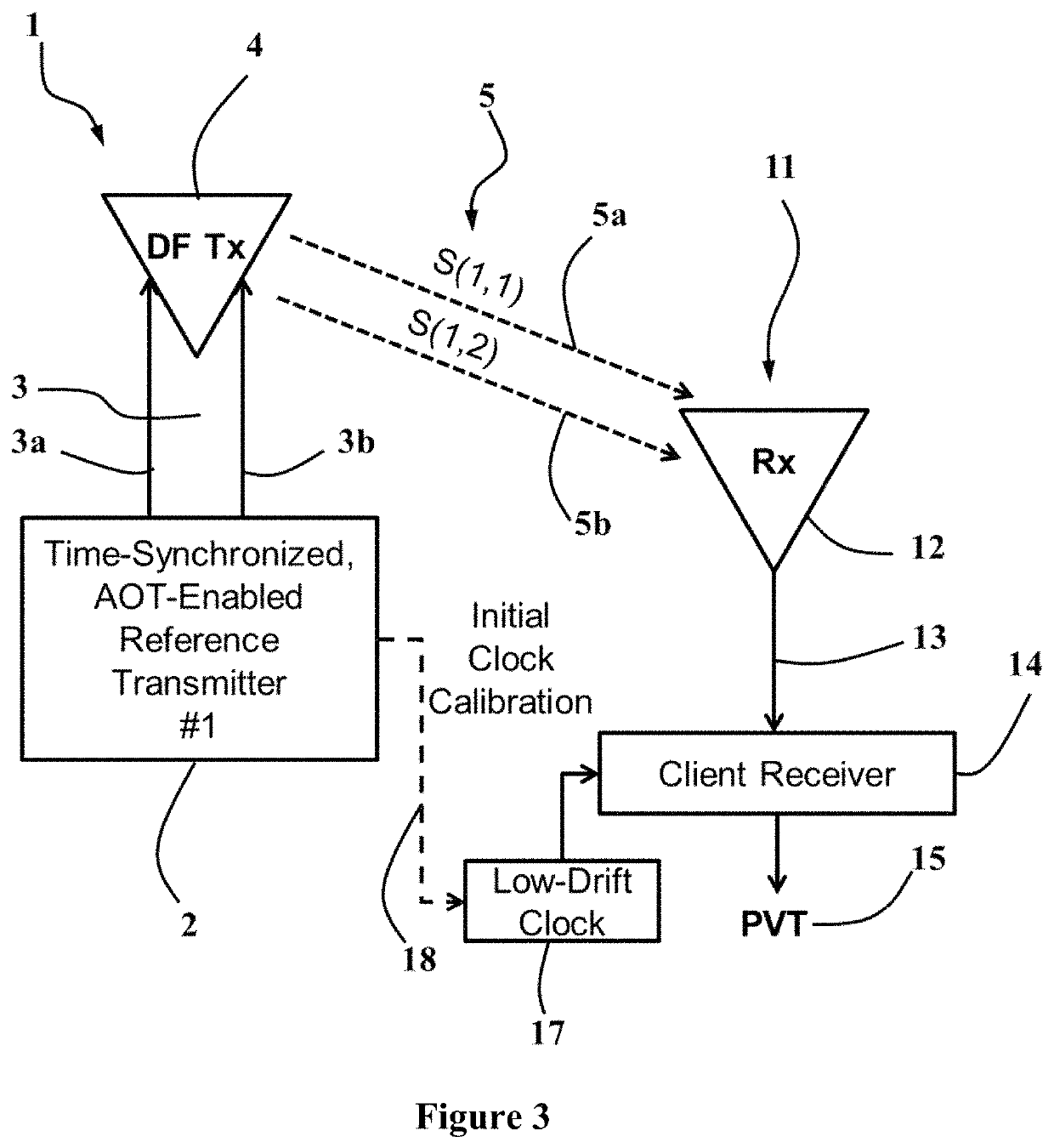
[0091]Referring now to the drawings, which are intended to illustrate presently preferred exemplary embodiments of the invention only and not for the purpose of limiting same, the navigation reference system concept is shown in FIG. 1. The main component of the present exemplary embodiment is a reference station 1, which consists of an angle-of-transmission-enabled electronics package 2 that generates at least two uniquely identifiable (PRN codes) and time-synchronized waveforms that are output to a feed network 3 having at least two feeds 3a, 3b.

[0092]The feeds 3a, 3b, are connected to a direction-finding (DF) transmit (Tx) antenna 4 supporting at least two DF modes or at least two elements. The emissions 5 of the DF antenna include the uniquely identifiable and time synchronized waveforms S(1,1) 5a and S(1,2) 5b, where S(i,j) refers to the jth waveform (of M) of the ith reference station (of N). Each reference waveform must be unique and differentiable from the other waveforms. H...


PUM


Abstract

An exemplary radio-frequency (RF)-based navigation reference system uses one or more non-collocated and time-synchronized direction-finding transmitters to enable a client receiver to estimate its own 3-D position, velocity and time (PVT) using direction-finding (DF) waveforms obtained from said reference transmitters. At least one reference transmitter is sufficient for obtaining a 3-D PVT solution provided the client receiver is equipped with an accurate (low-drift) local clock such as a chip-scale atomic clock (CSAC). All other client receivers require at least two reference transmitters to estimate their 3-D PVT.

Description

RELATED APPLICATIONS[0001]This non-provisional application claims priority rights pursuant to 35 U.S.C. § 119(e) based on U.S. Provisional Application Ser. No. 62 / 432,702 filed on Jan. 3, 2017, titled “System for Positioning, Navigation, and Time (PNT)” naming Kenan Osman Ezal and Gregory M. Johnson as inventors. Application Ser. No. 62 / 432,702 is hereby incorporated by reference.BACKGROUND1. Technical Field[0002]In general, the present application relates to the field of radio-frequency (RF)-based precision navigation and positioning systems. Specifically, it relates to radio-based navigation and positioning reference transmitters and client receivers for use with or in the absence of a Global Navigation Satellite System (GNSS) such as the Global Positioning System (GPS), Galileo, and GLONASS; as well as the field of precision relative positioning, navigation, and time (PNT).2. List of References[0003]U.S. Patents3,096,480July 1963Pihl342 / 76.833,495,247February 1970Perkins342 / 4013,...

Claims


Application Information

Patent Timeline
Patent Type & Authority Patents(United States)
IPC IPC(8): G01S5/02G01S19/46G01S19/05G01S1/20G01S5/10G01S5/14
CPCG01S1/20G01S5/145G01S5/10G01S5/0268G01S19/05G01S19/46G01S5/12G01S5/0247G01S1/14G01S5/02585G01S3/30G01S3/782G01S3/802
Inventor EZAL, KENAN OSMANJOHNSON, GREGORY M.
Owner TOYON RES CORP
Why Eureka
Try Eureka