Method for assigning particular classes of interest within measurement data

a technology of measurement data and class, applied in the field of method and system for surveying and/or metrology, can solve the problems of many computational challenges, unstructured acquired data, and inhomogeneous, and achieve the effects of improving current workflows, improving processes for assigning classes of interest, and enabling new workflows and applications

Active Publication Date: 2020-08-11
HEXAGON TECH CENT GMBH
View PDF10 Cites 5 Cited by
  • Summary
  • Abstract
  • Description
  • Claims
  • Application Information

AI Technical Summary

Benefits of technology

[0040]It is therefore an object of some embodiments of the present invention to improve processes for assigning classes of interest within measurement data in surveying and / or metrology, particularly by improving current workflows and / or by enabling new workflows and applications.
[0042]A further object of some embodiments is to reduce the error rate of automated classification, in particular to increase the object detection rate, to reduce false alarms and / or to reduce the need for human intervention.
[0048]In particular, with the inventive method suitable training data may be acquired and prepared with each measurement task, particularly reducing data storage, overhead time, and false classification, which lead to more accurate classification and more efficient training of a multitude of classifiers for a wide range of different applications.

Problems solved by technology

The assignment of such classes and subclasses within measurement data still requires time-consuming processes and the human eye and human judgement.
In attempt to automatize such assignment processes by computer implemented solutions many computational challenges are faced.
Often the acquired data are unstructured and highly inhomogeneous with strong variations in the point density, e.g. in a 3D point cloud, caused by a quadratic decrease of the point density with distance to the point cloud capturing device, as well as a decrease of laser / light intensity with distance and points falling below a detection threshold or points that are captured with reduced accuracy (low S / N).
For example, since buildings in Asia may look quite different from buildings in Europe, a classifier that is purely trained based on data captured in Europe might not work well in other regions of the world.
However, usage of machine learning algorithms requires a lot of training data.
The data acquisition, preparation and labeling requires a lot of efforts and time.
Summarizing, it is difficult in practice to use one pre-trained classifier for large varieties of different applications, definitions of classes, object's appearance, etc.
Even with increasing computing power and data storage, the large complexity required for automatically assigning particular classes of interest within measurement data pushes traditional methods, such as rule-based computational methods, to their limits, and a high degree of human interaction is still required.

Method used


Image

  • Method for assigning particular classes of interest within measurement data
  • Method for assigning particular classes of interest within measurement data
  • Method for assigning particular classes of interest within measurement data

Examples


Embodiment Construction

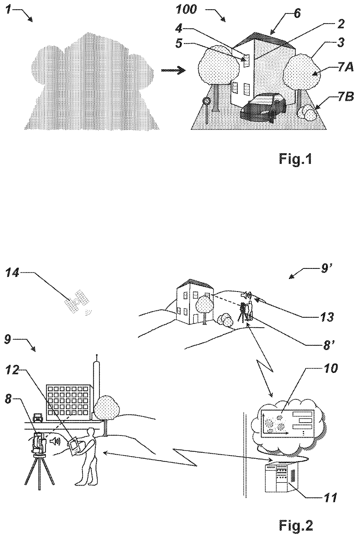
[0077]FIG. 1 shows an exemplary illustration for a classification process, here in the field of construction or building surveying, wherein raw measurement data of a scene, here a point cloud 1, for example recorded by a terrestrial lidar scanning system or a photogrammetric reconstruction system, is classified with geometric classes, e.g. such as edge lines 2, border lines 3, or rectangular window frames 4, and semantic classes and subclasses, e.g. such as windows 5, roof 6, vegetation, e.g. divided into (high) trees 7A and (low) bushes 7B, in order to transform the initial point cloud 1 into a higher level representation of the point cloud 100, e.g. for extracting more information or for monitoring purposes.

[0078]An automatic assignment of classes and subclasses within measurement data, e.g. a point cloud 1, often requires time-consuming preparation processes, in particular for defining dedicated classifying parameters, e.g. for the calculation of feature vectors consisting of poi...


PUM


Abstract

A method and system for surveying and / or metrology for assigning particular classes of interest within measurement data, wherein an assignment of at least one measurement object to a first class of interest within the measurement data based on a classification model, is processed by a feedback procedure providing feedback data for a training procedure which provides update information for the classification model, wherein the training procedure is based on a machine learning algorithm, e.g. relying on deep learning for supervised learning and / or unsupervised learning.

Description

CROSS-REFERENCE TO RELATED APPLICATIONS[0001]This application claims priority to European Patent Application No. 16206779 filed on Dec. 23, 2016. The foregoing patent application are incorporated herein by reference.FIELD OF INVENTION[0002]The present invention relates to a method and system for surveying and / or metrology. In particular, the present invention relates to a system and method for terrestrial surveying, airborne surveying, mobile mapping, a measurement by a total station, terrestrial laser scanning, a measurement by a coordinate measurement machine, a measurement by a laser tracker, a measurement by an articulated arm, and a measurement by a triangulation sensor, for assigning particular classes of interest within measurement data.BACKGROUND[0003]In the art of general classification of measurement data, raw data, e.g. point cloud data, imaging data (2D or 3D), multi-spectral data, radar data, lidar data, data by a total station, or data from a laser tracker, are transfo...

Claims


Application Information

Patent Timeline
Patent Type & Authority Patents(United States)
IPC IPC(8): G06K9/00G06K9/66G06K9/46G06K9/62G06V20/00
CPCG06K9/00624G06K9/00201G06K9/6262G06K9/46G06K9/6201G06K9/0063G06K9/66G06K9/00718G06T2207/30192G06F18/24G06V20/64G06V20/00G06V30/1916G06V20/41G06F18/22G06F18/217
Inventor METZLER, BERNHARDREIMANN, BERNDVELIZHEV, ALEXANDER
Owner HEXAGON TECH CENT GMBH
Why Eureka
Try Eureka