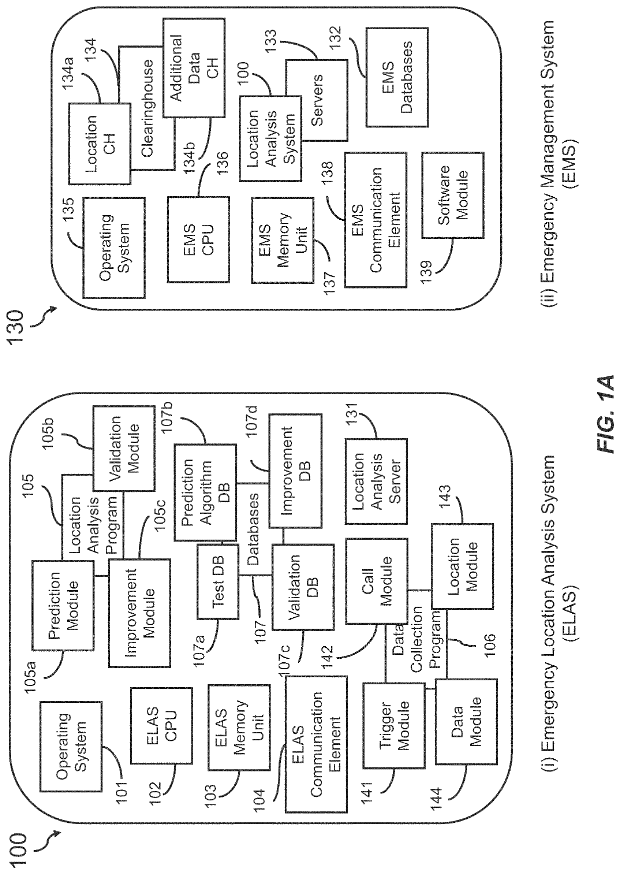
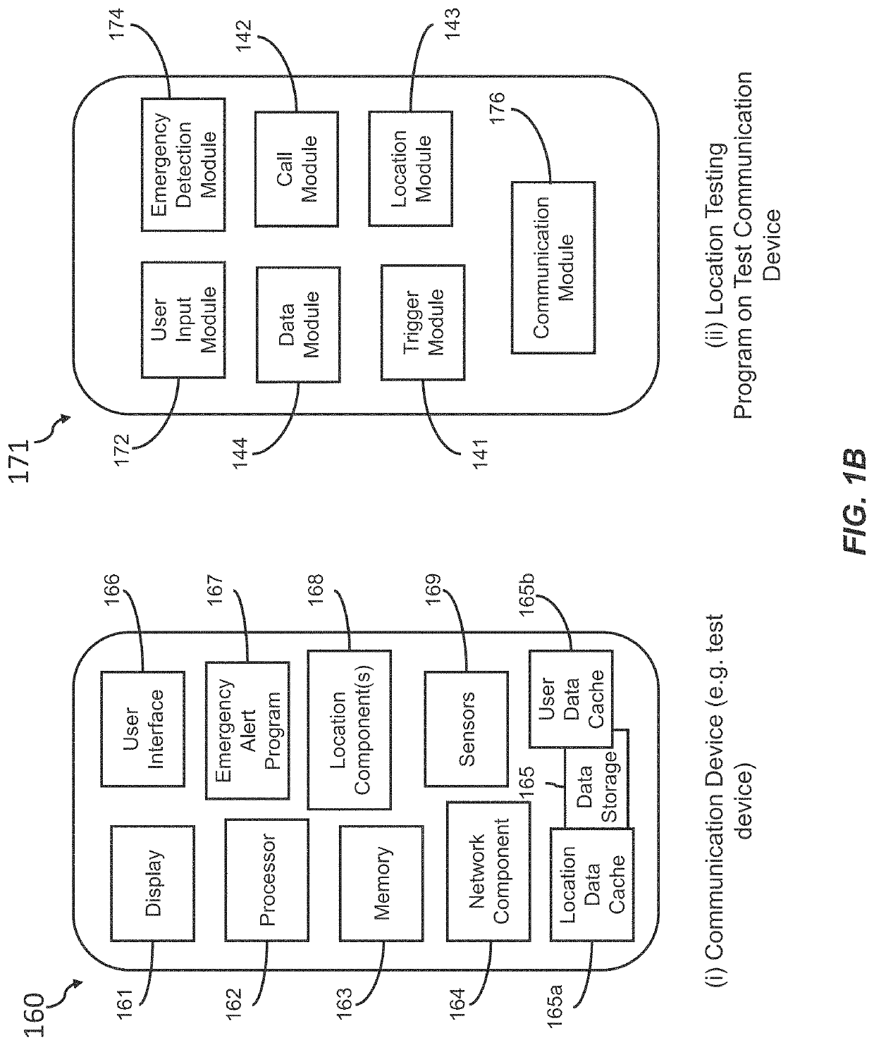
Emergency location analysis system
a technology of location analysis and emergency service, applied in the field of emergency location analysis system, can solve the problems of poor location accuracy of conventional methods for providing location information to emergency service providers
- Summary
- Abstract
- Description
- Claims
- Application Information
AI Technical Summary
Benefits of technology
Problems solved by technology
Method used
Image

Examples
example 1
[0309]In one instance, Jacob is in the backyard of his ranch style house in rural Virginia tilling his yard when he has a stroke. Petrified, Jacob reaches into his pocket and pulls out his cell phone—a Samsung Galaxy S8 running on the Verizon wireless network with Just In Time's location technology installed on the phone—and calls 9-1-1. Just In Time's location technology automatically identifies that Jacob has placed an emergency call to 9-1-1, indicating that he is in need of help, and generates a device-based hybrid location for the current location of cell phone. Although the coverage of the Verizon wireless network in Jacob's rural town is not the strongest, Jacob and his phone are outside, giving the GPS unit within Jacob's phone a clear line of sight to a satellite, and still within range of the Wi-Fi network set up in Jacob's home. The device-based hybrid location is sent to Just In Time's emergency management system, along with a list of attributes of Jacob's Samsung Galaxy...
example 2
[0312]In another instance, Nancy is walking home alone at 3 AM after a fun night out with her friends in Manhattan, N.Y. Halfway home, she begins to feel as though she is being followed. Moments later, she hears footsteps quickening behind her. Nancy turns to look behind her and sees a man she does not know but recognizes from the club she and her friends just left accompanied by two other men and quickly approaching her. When the men realize that Nancy has noticed them, they begin to chase after her. Nancy takes her cell phone—an old Apple iPhone 6 running on the AT&T wireless network with Just In Time's mobile app downloaded—out of her purse and begins to run while calling 9-1-1.
[0313]In this case, when Nancy calls 9-1-1, Just In Time's emergency management system receives an SMS text generated by the Just In Time mobile app including a device-based hybrid location generated from Nancy's cell phone and a list of attributes of Nancy's phone and her emergency call. The emergency man...
example 3
[0316]In a third instance, Rebecca is walking her dog, Charlie, through the woods in Rock Creek Park in Washington, D.C. Rebecca is scrolling through Instagram on her phone, a Samsung Galaxy S8 running on the T-Mobile wireless network, when Charlie takes off after a squirrel. Caught by surprise, Rebecca is jerked by Charlie's leash and badly twists her ankle over a tree root. She falls to the ground and is in too much pain to get up, so she dials 9-1-1 on her phone, which has Just In Time's location technology pre-installed. Upon dialing 9-1-1, a device-based hybrid location is generated from Rebecca's phone and sent to Just In Time's emergency management system, along with a list of attributes of Rebecca's Samsung Galaxy S8, wireless carrier, and more.
[0317]Just In Time's emergency management system transfers the device-based hybrid location to Just In Time's real-time location engine, which instantly begins analyzing the location and attributes in reference to the emergency call d...
PUM
 Abstract
Description
Claims
Application Information
 - R&D
- Intellectual Property
- Life Sciences
- Materials
- Tech Scout
- Unparalleled Data Quality
- Higher Quality Content
- 60% Fewer Hallucinations
Browse by: Latest US Patents, China's latest patents, Technical Efficacy Thesaurus, Application Domain, Technology Topic, Popular Technical Reports.
© 2025 PatSnap. All rights reserved.Legal|Privacy policy|Modern Slavery Act Transparency Statement|Sitemap|About US| Contact US: help@patsnap.com