System and method for providing position-based information to a user of a wireless device

a wireless device and position information technology, applied in the field of position determination systems, can solve the problems of limited local data storage capacity, time-consuming process of searching for four gps satellite broadcast signals, and errors in gps-calculated positions

Inactive Publication Date: 2002-11-07
QUALCOMM INC
View PDF0 Cites 216 Cited by
  • Summary
  • Abstract
  • Description
  • Claims
  • Application Information

AI Technical Summary

Problems solved by technology

Errors in the GPS-calculated position may be caused by atmospheric and tropospheric conditions, errors in the satellite data, reception errors and other error sources.
Unassisted, the process of searching for four GPS satellite broadcast signals can take minutes because most mobile GPS receivers lack accurate GPS satellite position information and, thus, lack information on where to look for the satellites.
The local data storage has limited capacity (often limited to a single metropolitan area or region) and the stored information becomes quickly out-dated as new buildings and roads are constructed, businesses change locations and other position-based information is changed.
However, this technique requires large and frequent downloads of display and position-related information and is not practical in current vehicle navigation systems.
Another disadvantage is that these vehicle navigation systems are costly and require installation in the vehicle.
Because these systems cannot be used away from the vehicle, a separate navigation system must be purchase for use while walking, riding a bicycle or other mobile activities.
Similar to the systems described above, these vehicle navigation systems are expensive and cannot be used away from the vehicle.
In addition, these vehicle navigation systems require the driver to be engaged in a conversation with the operator to audibly receive the requested information.
Although many modern mobile devices, such as mobile phones, pagers and personal digital assistants (PDAs), have been adapted to operate as GPS receivers, these devices typically include small screens and cumbersome menu interfaces and provide applications and services that are not suitable for use while driving a vehicle.

Method used


Image

  • System and method for providing position-based information to a user of a wireless device
  • System and method for providing position-based information to a user of a wireless device
  • System and method for providing position-based information to a user of a wireless device

Examples


Embodiment Construction

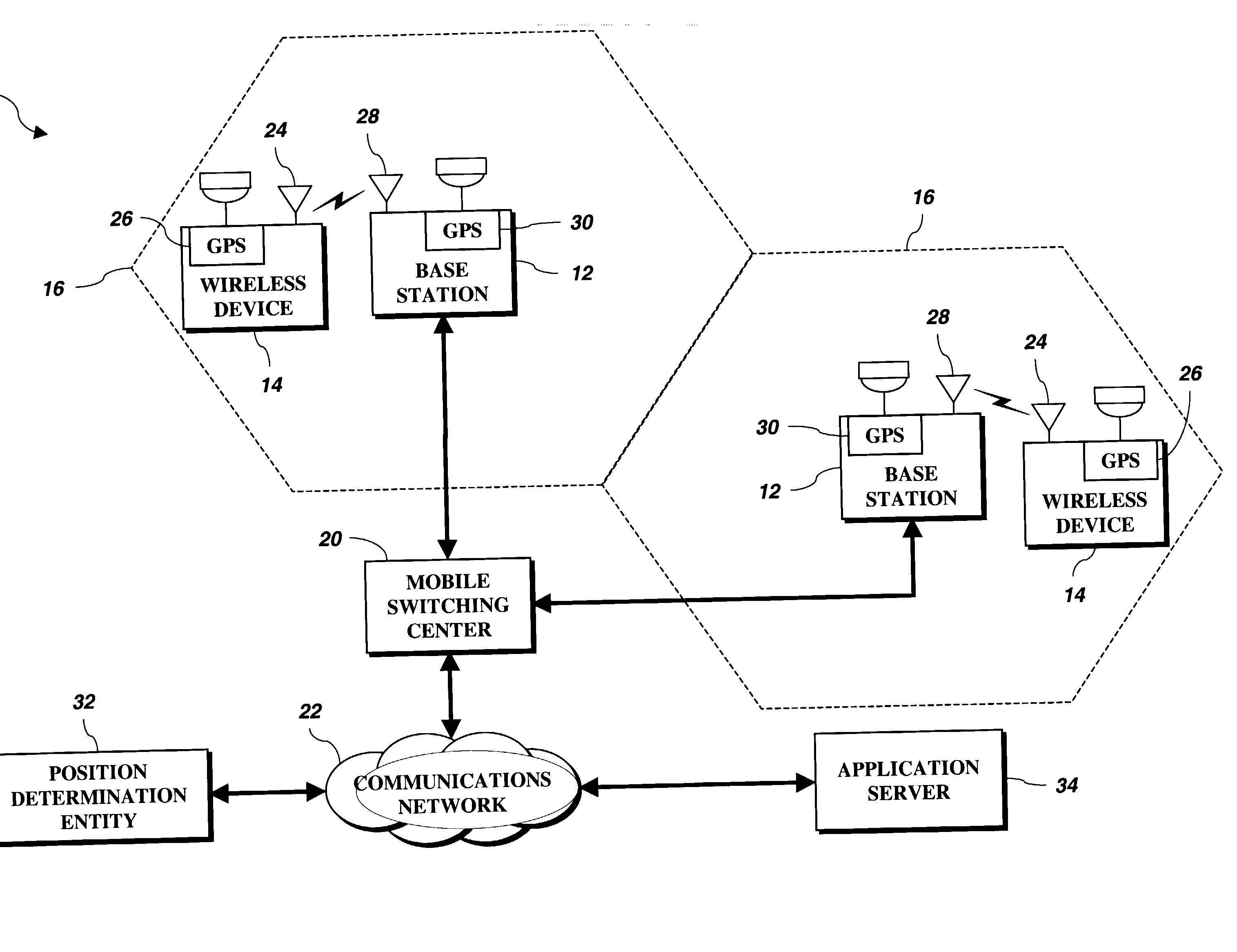
[0027] A system and method for providing position-related information to a user of a wireless device is disclosed herein. FIG. 1 illustrates a wireless communications system 10 in accordance with one embodiment of the disclosed method and apparatus. The wireless communications system 10 is shown as a cell-based communication system including a plurality of base stations 12 and a plurality of wireless devices 14. Each base station 12 has an associated cell 16 defining a geographical coverage area serviced by the base station 12. Each wireless device 14 positioned within one of the cells 16 communicates with the associated base station 12 by exchanging data packets according to a predetermined digital communications protocol, such as code division multiple access (CDMA). The wireless devices 14 may be any devices capable of communicating with the base stations 12 over a wireless communications link, including mobile telephones, personal digital assistants (PDAs), vehicle navigation sy...


PUM


Abstract

In a wireless network including a base station, an application server, a position determining entity and a mobile phone, a method for using the mobile phone as a vehicle navigation device. The mobile phone detects a user activated request for driving directions and establishes voice and data communications links with the application server through the base station. The user vocally transmits the request and a destination location to the application server. Using wireless assisted GPS, the mobile phone determines its position and transmits its position to the position determining entity. The mobile phone receives the requested driving directions from the application server through the data communications link and provides audible driving directions to the user. In operation, the application server receives the request for position-related information, retrieves the position of the mobile phone from the position determining entity and processes the request for information in accordance with the position of the wireless device.

Description

[0001] This application claims priority to U.S. Provisional Application No. 60 / 287,901, filed on May 1, 2001.[0002] 1. Field of the Invention[0003] The disclosed method and apparatus relates generally to position determination systems and, more specifically, to systems and methods for providing position-based information to a user of a wireless device.[0004] 2. Description of the Related Art[0005] Systems for determining the geographic position of a wireless device are well known in the art. A commonly used position determination system is the Global Positioning System (GPS) operated by the United States Department of Defense. The GPS includes a network of 24 satellites that orbit the earth in six circular planes. The GPS satellites are spaced so that, at any given time and from any geographic position, at least five GPS satellites will be above the horizon. In operation, each GPS satellite continually broadcasts its present position and current time. On earth, a GPS receiver may us...

Claims


Application Information

Patent Timeline
Patent Type & Authority Applications(United States)
IPC IPC(8): G01S1/00G01S5/14G01S19/25H04W4/02H04W4/024
CPCG01S19/06H04W4/02G01S19/09H04W4/024
Inventor YOUNIS, SAED
Owner QUALCOMM INC
Why Eureka
Try Eureka