Digital altimetric map drawing method and device

a digital topographic map and drawing method technology, applied in the direction of 2d-image generation, maps/plans/charts, instruments, etc., can solve the problems of difficulty, low accuracy and/or reliability of topographic maps, and inability to produce smoothly curved lines, etc., to achieve short time, less artificial mistakes, and easy to use

Inactive Publication Date: 2005-05-19
DGS COMP
View PDF13 Cites 35 Cited by
  • Summary
  • Abstract
  • Description
  • Claims
  • Application Information

AI Technical Summary

Benefits of technology

[0009] With this, through processing each of the steps by means of a computer, the digital topographic map can be obtained, on which the contour lines are displayed by smoothly curved-lines, in a short time, easily, and also there occurs less artificial mistakes, comparing to the case where an extensive amount of measurement data is processed by handworks; therefore, an improvement can be achieved, greatly, in particular, on accuracy and reliability of the topographic map.
[0038] With this, the digital topographic map can be obtained, on which the contour lines are displayed by smoothly curved-lines, in a short time, easily, and also there occurs less artificial mistakes, comparing to the case where an extensive amount of measurement data is processed by handworks; therefore, an improvement can be achieved, greatly, in particular, on accuracy and reliability of the topographic map.

Problems solved by technology

With the method mentioned above, however, for obtaining such the map, but being much higher in the accuracy thereof, it must be produced from an expansively large number of the measured points, and then it necessitates much times and labors for producing the contour lines, and also, since the map must be produced through treating or handling the survey data obtained, by hands, then there will easily occurs artificial errors therein, as well as, necessitating much times and labors therein; therefore, there is a problem or a drawback that the topographic map produced is low in accuracy and / or reliability thereof, and so on.
However, with such the method of the former, there is a drawback that a topographic map cannot be produced with smoothly curved lines, due to unevenness or ununiformity in the property of the digital data obtained, etc., and also with such the method of the latter, there is a drawback that difficulty is accompanied with, in particular, on the processing thereof, because an mount of the coordinate data is expansively large.
Also, with the conventional topographic map, even if the data of the contour line is vector data of digital, however since the contour line itself has not the information about a direction of height, i.e., three(3)-dimensional information, there are also the following drawbacks; for example, it is impossible to read out a difference of altitude on the configuration of the land when planning a road on the map, or to make a simulation, in particular, when trying it by means of a CAD, upon the way of gathering and / or rushing into a valley when rain falls in an area of the valley presented on the map, or upon in which direction the water flows out when rain falls on a watershed or a dividing ridge, on the boundary thereof, or upon the location at which a steel tower should be constructed on the map, so as to lay a power-transmission line or a communication line, or upon the way or the direction of pyroclastic flow, when a volcano erupts, or upon the way, how a seismic sea wave comes up to the shoreline, etc.

Method used


Image

  • Digital altimetric map drawing method and device
  • Digital altimetric map drawing method and device
  • Digital altimetric map drawing method and device

Examples


Embodiment Construction

[0064] Hereinafter, embodiments according to the present invention will be fully explained by referring to the attached drawings.

[0065] First of all, explanation will be made briefly, on a UTM drawing method, for producing a topographic map, to be a basis thereof, when producing the digital topographic map.

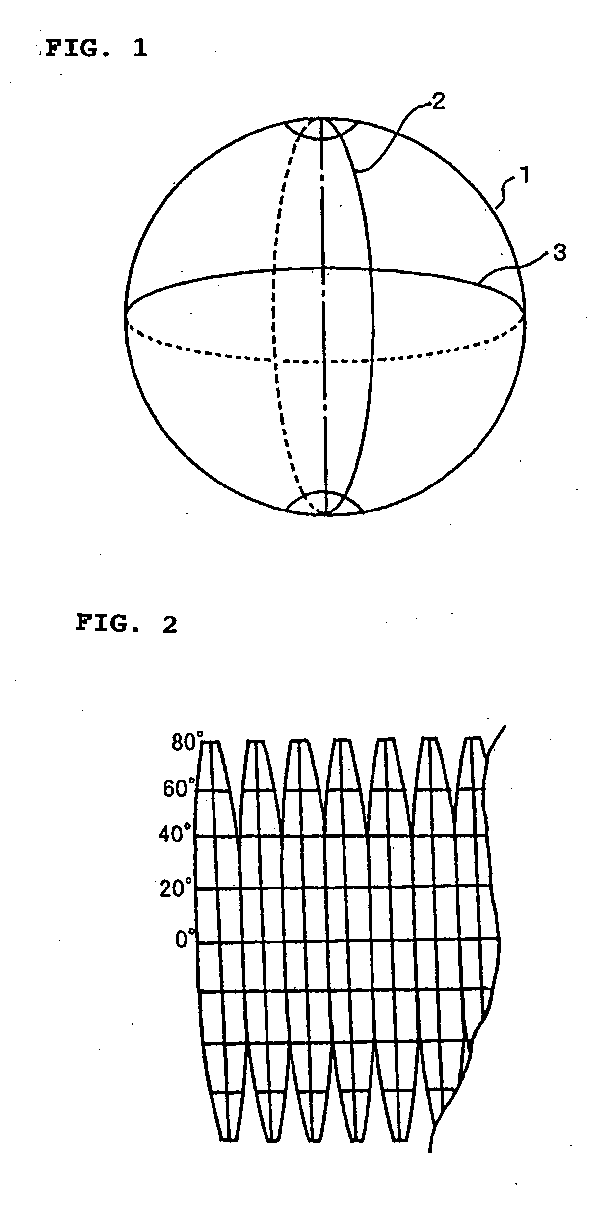
[0066] As is shown in FIG. 1, lines connecting between the North Pole and the South Pole, orthogonally crossing the equator, on the earth 1 forming a sphere, are longitude lines 2, and those are latitude lines 3, orthogonally crossing those longitude lines.

[0067] When dividing the earth by an angle 6° defined between the longitude lines 2 neighboring to each other, for example, 6° pieces of lines can be drawn onto the earth 1 having the angle of 360°, by one (1) round, and then the longitude can be defined by those longitude lines 2, in the order or sequence thereof.

[0068] Also, the latitude can be defined, by assuming that the equator be 0°, while the North Pole and the South...


PUM


Abstract

A method for producing a digital topographic map, comprising the following steps of: a step for dividing a basic map, which is produced through UTM drawing method, into grid-like sectors at a predetermined distance, and further dividing the sector obtained into a smaller one (4), thereby producing small sectors while interpolating discontinuous data being in short between each sectors and within each of the sectors; a step for producing digital data by relating x,y coordinates of the small sector (4) obtained and a sea level obtained through measurement, upon basis of an algorithm having a rationality, and connecting the small sectors (4) being same in the sea level thereof with a straight line, thereby producing a first topographic map (5), on which contour lines (6) are formed with lines of segments; and a step for conducting a smoothing process upon the contour lines (6) of said first topographic map (5), mathematically, thereby producing a second topographic map (7), on which the contour lines (6) are formed with curved lines, being smoother than the contour liens (6) of said first topographic map, which are formed with the lines of segments, thereby enabling to obtain the digital topographic map, displaying the contour lines (6) with smoothly curved lines thereon.

Description

TECHNICAL FIELD [0001] The present invention relates to a producing method of producing a digital topographic map, by producing contour lines through mathematical processing of survey data, and in particular, it relates to a producing method and a producing apparatus of producing a digital topographic map, for producing the digital topographic map by composing map elements thereon, such as, a sea shoreline, a river, a lake, a railway, a road, a building, etc., for example, which are already digitalized, by using the contour lines, which are produced through such the mathematical processing of the survey data. BACKGROUND ARTS [0002] Conventionally, on a map or a topographic map produced by Geographical Survey Institute of Japan, ups and downs or relief upon the surface of the earth are presented by means of the contour lines displayed thereon, however when producing such a map displaying such the contour lines thereon, it is produced by connecting between the measured points, which a...

Claims


Application Information

Patent Timeline
Patent Type & Authority Applications(United States)
IPC IPC(8): G06T17/05G09B29/00G09B29/12
CPCG09B29/12G09B29/005G09B29/00
Inventor IWATA, KANSEIDANIEL, VISANPICU, FLORIN
Owner DGS COMP
Why Eureka
Try Eureka