
Apparatus and method for processing and displaying traffic information in an automotive navigation system

a technology for navigation systems and vehicles, applied in the field of automobile navigation systems, can solve the problems of limited utility, inability to provide information, and inability to transmit traffic data by satellite,

Active Publication Date: 2006-03-16
CLARION CO LTD
View PDF36 Cites 129 Cited by
  • Summary
  • Abstract
  • Description
  • Claims
  • Application Information

AI Technical Summary

Benefits of technology

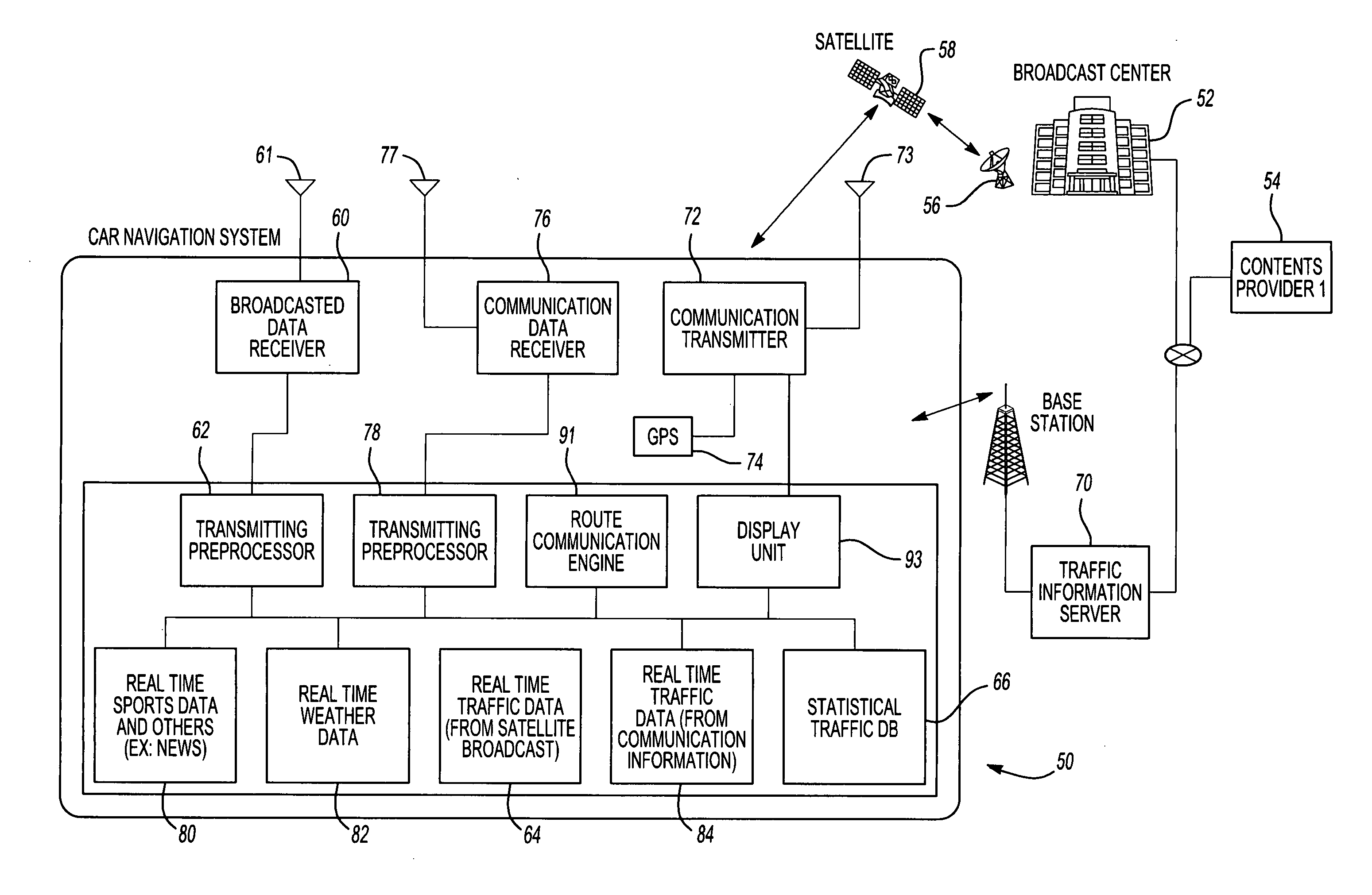
[0014] A communication receiver then receives the local traffic data from the communication system in response to the data request and stores that information in memory. Preferably, the data from the communication system is compared with the data received from the broadcast system to eliminate any redundant data between the broadcast traffic data and the local traffic data.

Problems solved by technology

One disadvantage of the previously known navigation systems, however, is that the traffic data transmitted by satellite is necessarily limited to major roads and does not include traffic flow data for local roads in the geographic area.
Consequently, these previously known navigation systems provide little or no information with respect to traffic flow along the local roads and are thus of limited utility for predicting local traffic flow and rerouting of the vehicle to a selected destination to minimize travel time.
A still further disadvantage of these previously known navigation systems is that such navigation systems only provide traffic flow data of the currently existing conditions.
For example, weather conditions, such as a predicted snowstorm, may significantly impact the traffic flow conditions during the expected travel of the vehicle from its current position and to the selected destination.
Likewise, other temporal non-traffic events, such as sporting events, parades, and the like, may also impact the traffic flow along the anticipated route of the vehicle.
A still further disadvantage of these previously known navigation systems is that such navigation systems fail to use statistical or historical data of traffic flow conditions along road segments in the locality frequently traveled by the vehicle as a function of time.
For example, certain road segments may encounter excessive congestion during weekday rush hours, and yet have little or no traffic congestion during the non-rush hours or weekends.
As such, these previously known navigation systems were unable to predict favorable routes for the vehicle to the desired destination while taking into account such historical statistical data.

Method used


Image

  • Apparatus and method for processing and displaying traffic information in an automotive navigation system
  • Apparatus and method for processing and displaying traffic information in an automotive navigation system
  • Apparatus and method for processing and displaying traffic information in an automotive navigation system

Examples


Embodiment Construction

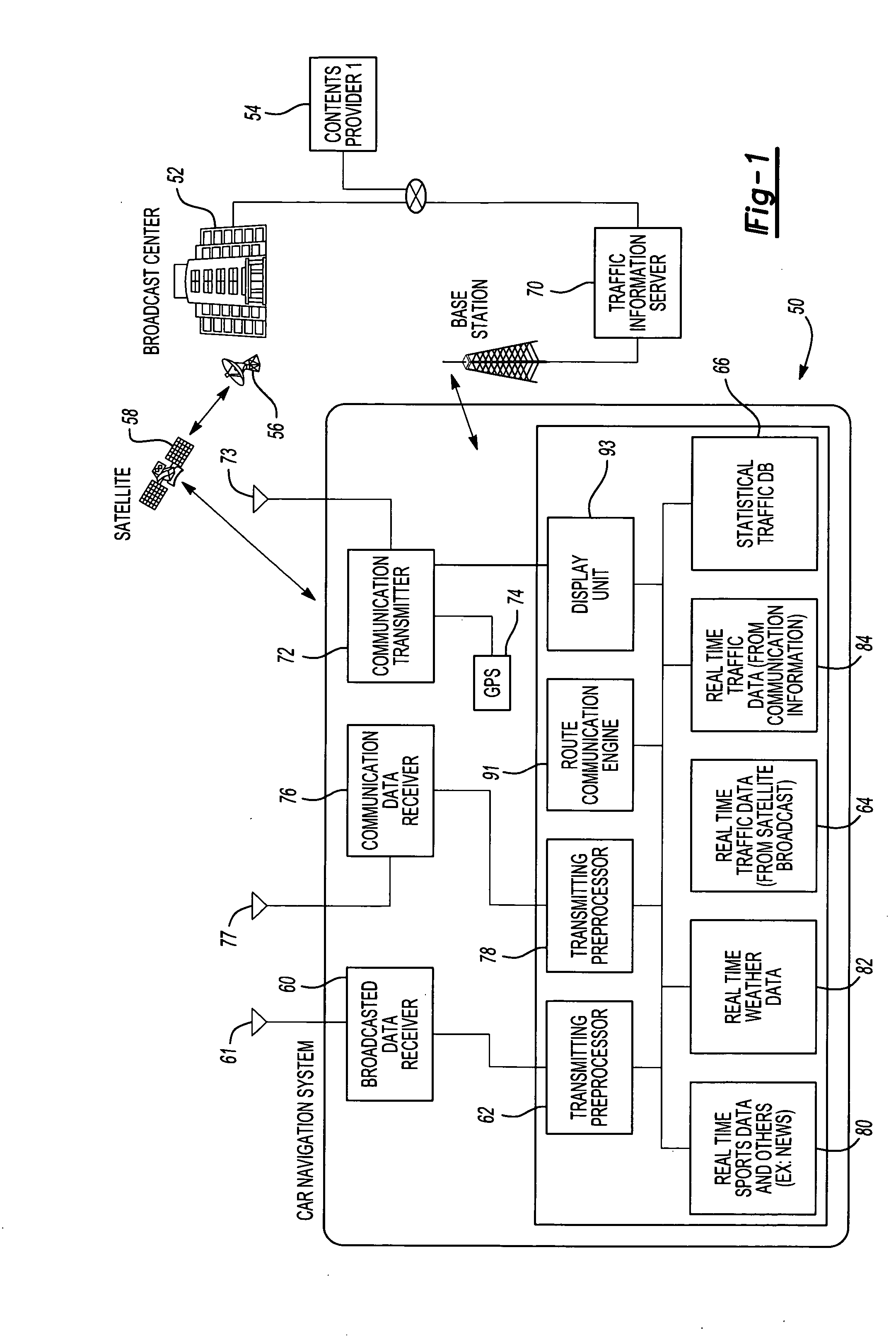
[0041] With reference first to FIG. 1, a block diagrammatic view of a preferred embodiment of a car navigation system 50 is shown for use with a central station 52 which collects traffic data across a geographical area, such as the United States, from a plurality of traffic content providers 54, such as traffic flow sensors. Other data collecting devices and sources can include traffic cameras, traffic information collected by police or highway departments, website sentry collected information, speed sensors located in cars and transmitted to a central server, speed calculations made from the car position, as well as any other source indicative of traffic flow conditions.

[0042] The central station 52 then collates the inputted data from the sensors 54 and transmits via a transmitting antenna 56 to a satellite 58. The satellite 58 then retransmits the collated data back to the earth where it is received by a data receiver 60 of the navigation system 50.

[0043] Since the central stat...


PUM


Abstract

A vehicle navigation system for use with a traffic information broadcast system which transmits traffic data relating to primary road segments and a communication system which transmits traffic data relating to road segments in a local geographic area. A broadcast receiver receives the broadcast traffic data from the broadcast system and stores the received data. A communication transmitter, when activated, transmits a data request to the communication system. A communication receiver receives the local traffic data from the communication system in response to the data request while a processor displays traffic information on a display screen corresponding to the received broadcast traffic data and the received local traffic data. The local traffic data includes both traffic information relating to local road segments as well as non-traffic temporal events, such as weather, and time-related events which affect traffic flow.

Description

CROSS-REFERENCE TO RELATED APPLICATIONS [0001] This application is a continuation-in-part of U.S. patent application Ser. No. 10 / 938,813, entitled “System and Method for Processing and Displaying Traffic Information in an Automotive Navigation System,” filed Sep. 10, 2004, and which is hereby incorporated herein by reference.BACKGROUND OF THE INVENTION [0002] I. Field of the Invention [0003] The present invention relates generally to automotive navigation systems and, more particularly, to such a navigation system which processes both nationally broadcast traffic data and locally broadcast traffic data. [0004] II. Description of Related Art [0005] Automotive navigation systems have become increasing prevalent in automotive vehicles. Such navigation systems typically include a display screen mounted in the vehicle in a position visible to the driver. A roadmap is displayed on the screen from an internally contained map database and, by utilizing GPS to determine the position of the v...

Claims


Application Information

Patent Timeline
Patent Type & Authority Applications(United States)
IPC IPC(8): G01C21/32G08G1/00
CPCB60R11/04G01C21/28G08G1/0962G08G1/096716G08G1/096741G08G1/096894G08G1/096775G08G1/096827G08G1/096838G08G1/09685G08G1/09675
Inventor KATO, MANABURAMASWAMY, DEEPAK
Owner CLARION CO LTD
Learn More