Method for handling location data

a technology for location data and data processing, applied in the field of location data processing, can solve the problems of inoperable system, adding to the cost of operation, and unable to operate, and achieve the effect of substantially facilitating the subsequent search and/or analysis of the collected geographical positions

Inactive Publication Date: 2006-07-06
NOKIA TECHNOLOGLES OY
View PDF17 Cites 79 Cited by
  • Summary
  • Abstract
  • Description
  • Claims
  • Application Information

AI Technical Summary

Benefits of technology

[0028] Thus, a current geographical location that has a user's interest can readily be stored in the mobile terminal. There is no need to be in connection with a server or remote device. The hand portable terminal automatically prompts for a name and label to be associated with the stored geographical position. The user will thus not forget to assign name and category to the stored positions. This ensures that a subsequent search and / or analysis of the collected geographical positions is substantially facilitated.

Problems solved by technology

This system requires intensive communication between the vehicle based system and the remote apparatus, adding to the cost of operation and cannot operate when the mobile apparatus cannot reach the remote apparatus.
This system requires intensive communication between the laptop and the service server, adding to the cost of operation and rendring the system inoperable when the laptop computer cannot reach the server.

Method used


Image

  • Method for handling location data
  • Method for handling location data
  • Method for handling location data

Examples


Embodiment Construction

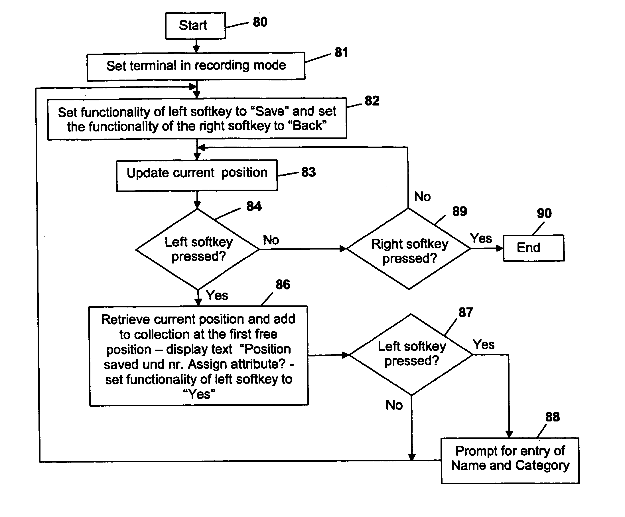
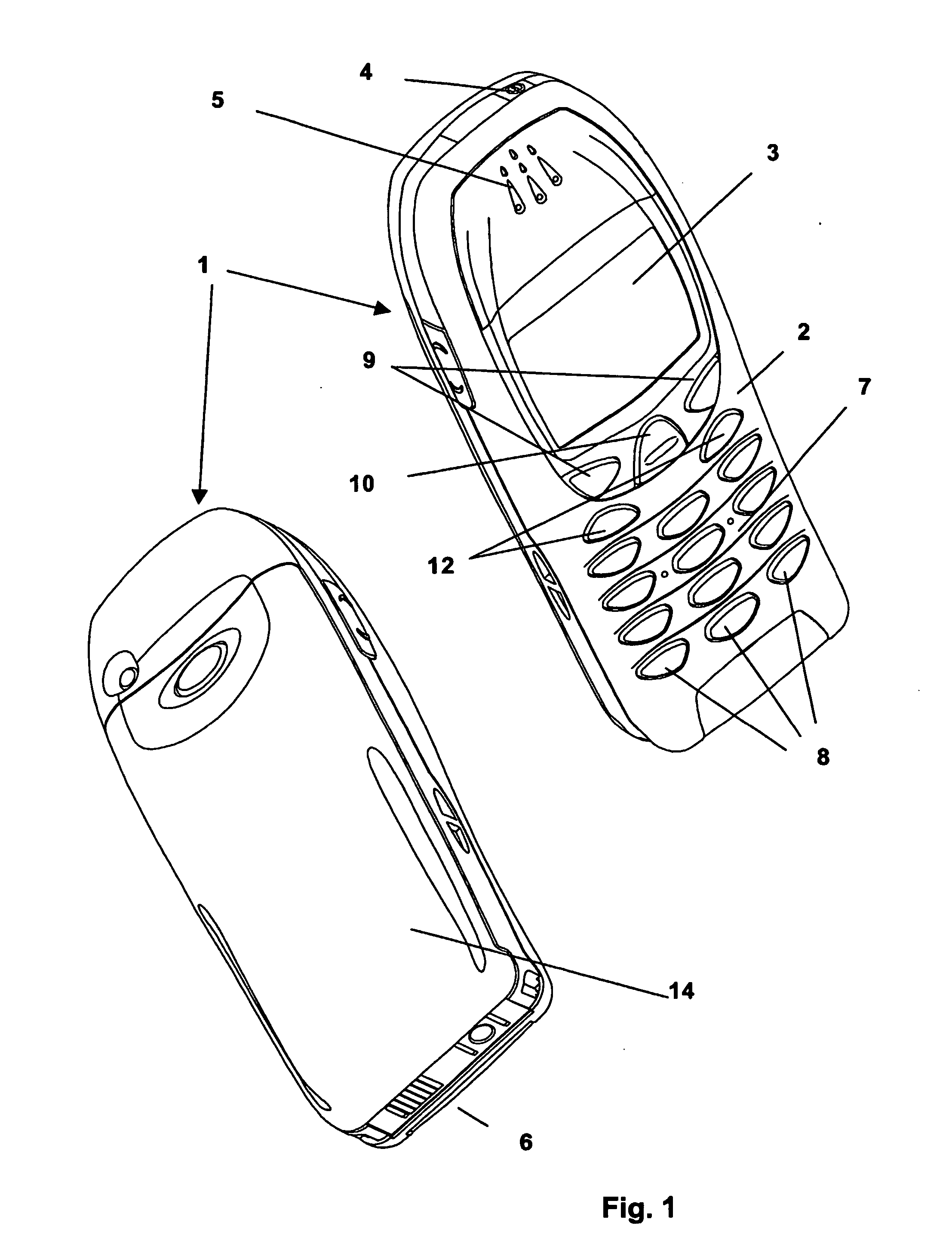
[0047] The following detailed description, illustrates the mobile terminal according to the invention in the form of a hand portable phone, preferably a cellular / mobile phone. The invention can however also be carried out with any other mobile terminal having some form of positioning system and means for storing data, such as personal digital assistants (PDA) or GPS navigation terminals.

[0048]FIG. 1 shows a mobile phone according to the invention. The phone 1 comprises a user interface having a keypad 2, a display 3, an on / off button 4, a speaker 5 (only the openings are shown), and a microphone 6 (only the opening is shown). The phone 1 according to the preferred embodiment is adapted for communication via a cellular network, such as the GSM 900 / 1800 MHz network.

[0049] The keypad 2 has a first group 7 of keys 8 as alphanumeric keys, by means of which the user can enter a telephone number, write a text message (SMS), write a name (associated with the phone number), etc. Each of th...


PUM


Abstract

A method, a device and an application for creating a collection of selected geographical positions that have been visited by the device. The mobile terminal has a geographical position system and a memory for containing the collection of selected geographical positions. A current position of interest is obtained or determined by the terminal's positioning system and stored in the memory upon a user input. The stored geographical positions can be provided with attributes such as names and categories. Mobile terminals can exchange stored geographical positions via cable. IR, RF or cellular communication. A collection of geographical positions can be subjected to statistical and probability analysis, and a map can be generated to visualize the results of the analysis.

Description

[0001] The present invention relates generally to handling of geographical locations and more particularly to a method, an application and a device for creating a collection of selected geographical positions that have been visited by the device. BACKGROUND ART [0002] U.S. Pat. No. 6,459,987 discloses a method for automatically generating a backtrack route, using the aid of Global Positioning System technology. The method records a series of data points along a traversed route. The data is used for backtrack navigation. [0003] U.S. Pat. No. 6,477,461 discloses a navigation system for vehicles that has a rewritable memory which stores data of a plurality of locations, and searches the rewritable memory for a target location for use in guiding a travel route. Users can input a new location for registration manually by specifying a new location on a map. The data of a new location is stored in the rewritable memory in addition to original data of the plurality of locations. When a user...

Claims


Application Information

Patent Timeline
Patent Type & Authority Applications(United States)
IPC IPC(8): H04Q7/20G01C21/20G01S5/00G01S5/02H04W4/02H04W4/029
CPCG01C21/20G01S5/0072G01S5/0252H04W4/02H04W4/028H04W4/029G01S5/02524
Inventor SYRBE, HANNO
Owner NOKIA TECHNOLOGLES OY
Why Eureka
Try Eureka