Ground-based Sense-and-Avoid Display System (SAVDS) for unmanned aerial vehicles

a display system and unmanned aerial vehicle technology, applied in the field of ground-based sense-and-avoid display system for unmanned aerial vehicles, can solve the problems of limited low-altitude uav operations, lack of a standardized approach, and difficulty in effectively sensing

Inactive Publication Date: 2006-11-09
HERWITZ STANLEY R
View PDF3 Cites 51 Cited by
  • Summary
  • Abstract
  • Description
  • Claims
  • Application Information

AI Technical Summary

Benefits of technology

[0006] The present invention is a Sense-and-Avoid Display System (SAVDS) that integrates data from a ground-based short-range tracking radar with positional data from the global positioning system (GPS) element of the UAV's flight management autopilot system. Using a high-resolution display, the SAVDS shows the GPS location of the UAV in relation to other local aircraft detected using a portable ground-based tracking radar system. With the SAVDS co-located on the same tabletop as the computer controlling the UAV, the SAVDS can provide UAV pilots with the requisite information needed to change

Problems solved by technology

The problem identified by the FAA is the challenge of effectively sensing conflicting aircraft when the UAV is out of visual range of the ground-based UAV pilot.
The lack of a standardized approach has previously limited low altitude UAV operations to line-of-sight activities that require dedicated sets of eyes to identify any potential airspace conflicts.
This limitation has restricted most approved UAV operations to flight heights of less than 2,000 ft and distances of less

Method used


Image

  • Ground-based Sense-and-Avoid Display System (SAVDS) for unmanned aerial vehicles
  • Ground-based Sense-and-Avoid Display System (SAVDS) for unmanned aerial vehicles
  • Ground-based Sense-and-Avoid Display System (SAVDS) for unmanned aerial vehicles

Examples


Embodiment Construction

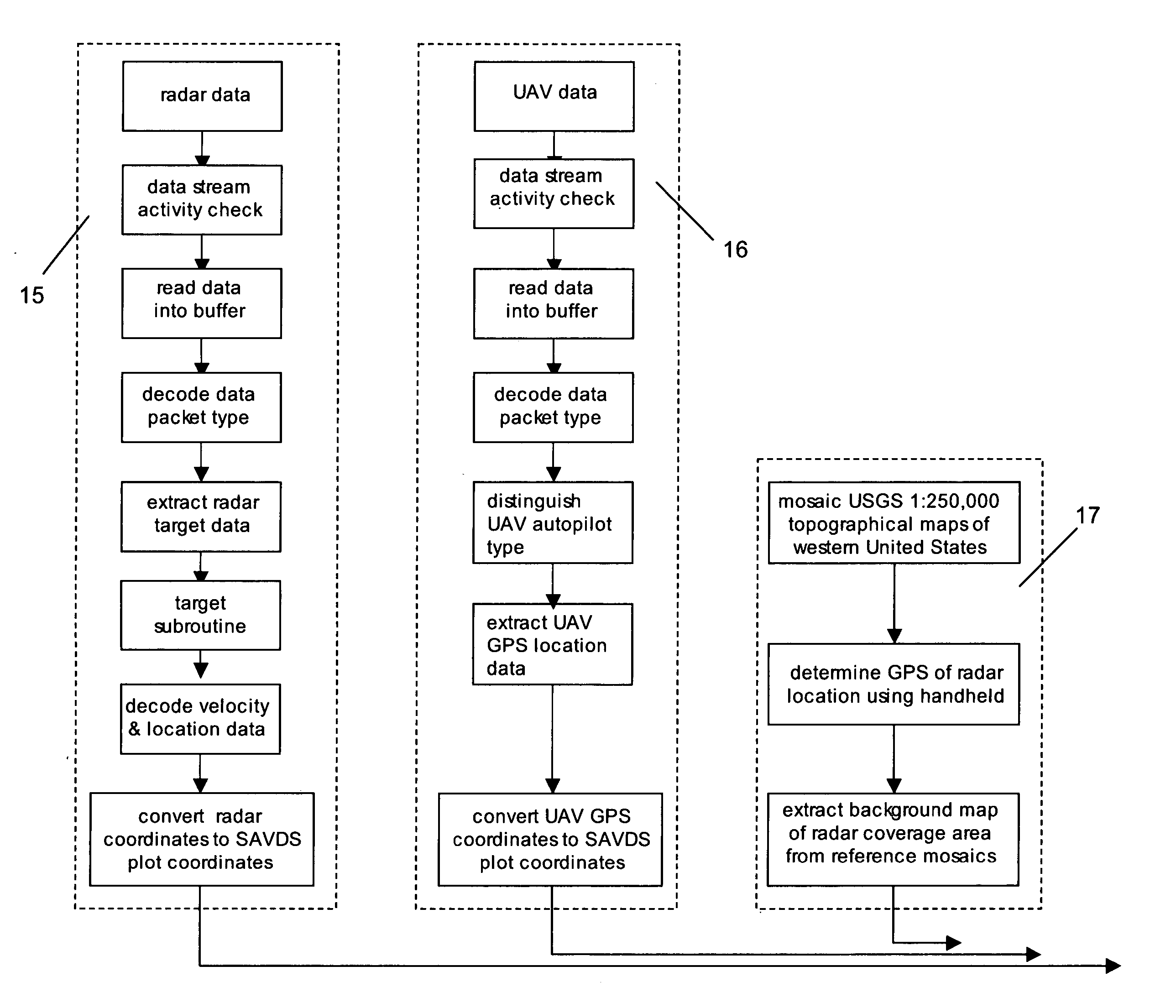
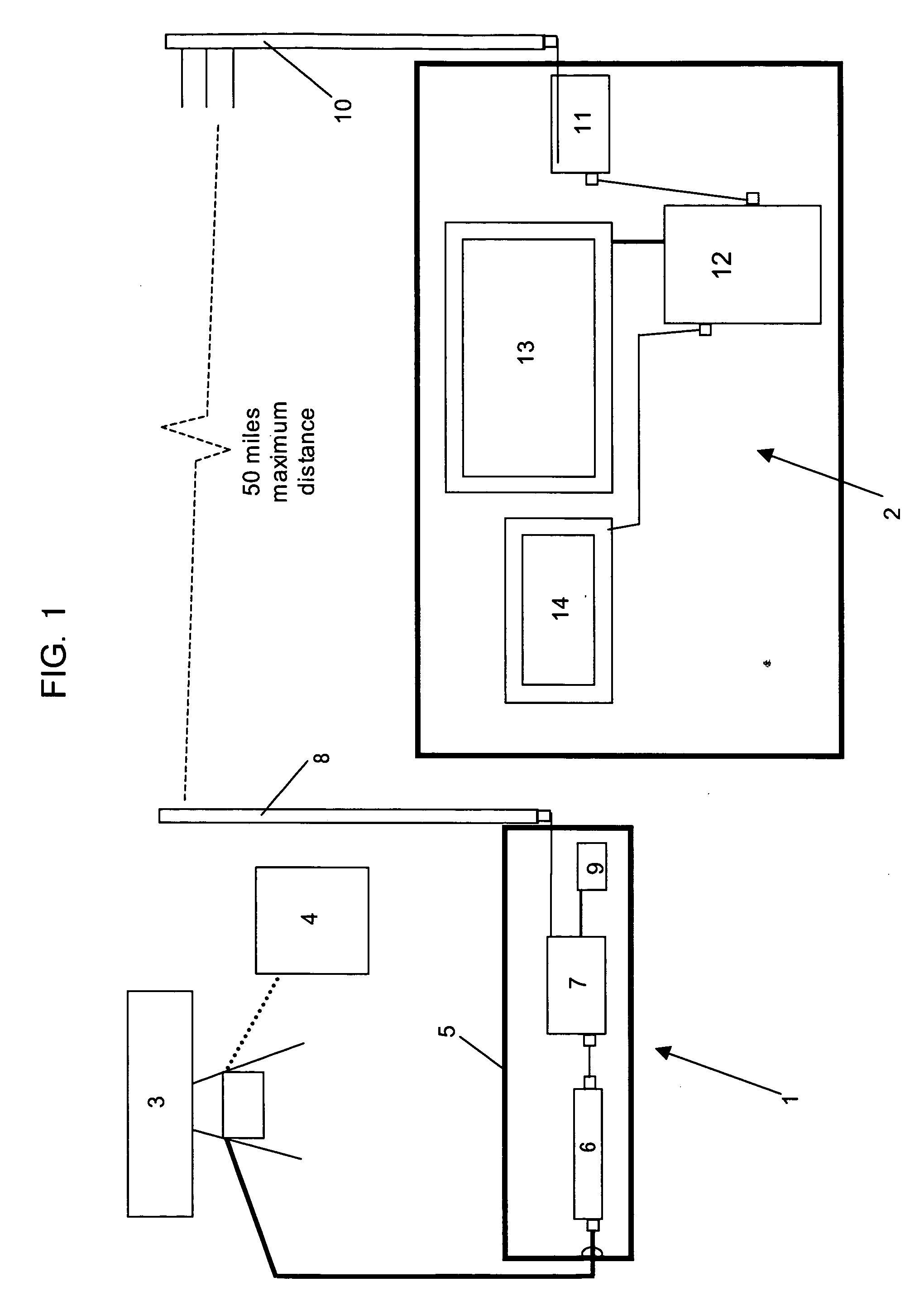
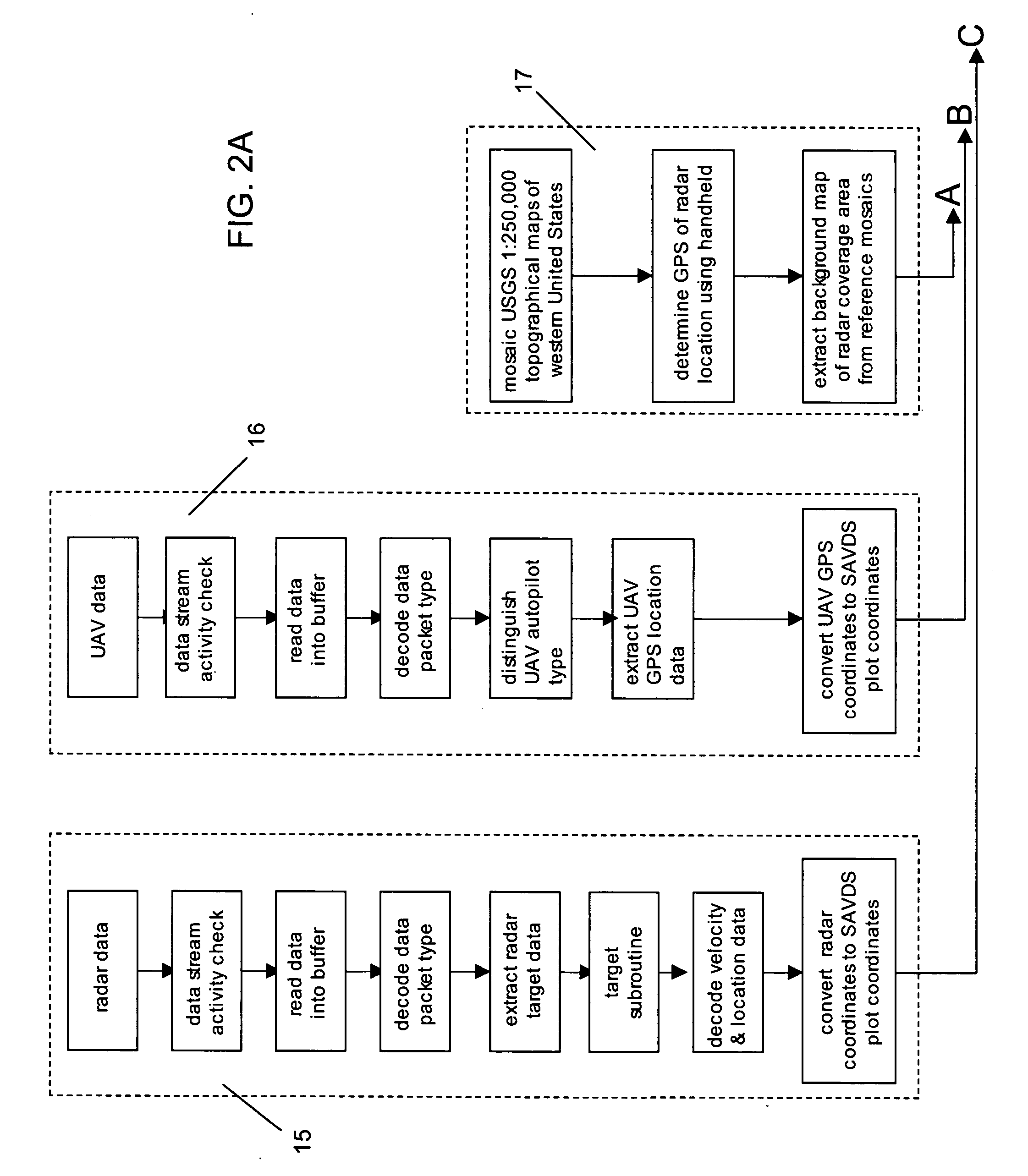
[0009] With reference to FIG. 1, the SAVDS system includes two functional subsystems: data transfer station 1 and mobile ground station 2. Data transfer station 1 further comprises a small, short-range ground-based radar 3, such as the Light and Special Divisions Interim Sensor (LSDIS) radar manufactured by Lockheed Martin. Radar 3 is connected to a primary electric power supply 4 that may comprise any portable generator or typical facility power common in the art. Output from radar 3 is routed into a weatherproof case 5. Within case 5, radar data is minimally conditioned by an element of the LSDIS radar called the control indicator unit 6. Control indicator unit 6 may be powered by the same energy source as the radar 3. Control indicator unit 6 passes radar data to a wireless, frequency-hopping, spread-spectrum, first radio transceiver 7 such as those made by FreeWave Technologies. First radio transceiver 7 emits the radar data via an omnidirectional antenna 8 mounted on the extern...


PUM


Abstract

The present invention is a Sense-and-Avoid Display System (SAVDS) that integrates data from a ground-based short-range tracking radar with positional data from a global positioning system (GPS) element in the flight management autopilot system in the unmanned aerial vehicle. Using a high-resolution display, the SAVDS shows the GPS location of the unmanned aerial vehicle in relation to other aircraft operating in the same airspace. With the SAVDS co-located on the same tabletop as the computer controlling the unmanned aerial vehicle, the SAVDS operator can instruct the unmanned aerial vehicle pilot to change the heading of the vehicle until any potential aircraft conflict is abated. Ground-based radar data and GPS data are integrated and displayed with georeferenced base maps that provide collision avoidance information, and provide a means for tracking the UAV relative to geographic waypoints.

Description

BACKGROUND OF THE INVENTION [0001] 1. Field of the Invention [0002] The present invention relates to the field of unmanned aerial vehicles (UAVs). Specifically, the invention relates to a system that integrates real-time tracking radar data with the positional data of a UAV to identify collision threats. The acronym for the innovation is SAVDS (Sense-and-Avoid Display System). [0003] 2. Description of the Prior Art [0004] UAVs must share the National Airspace System (NAS) with piloted aircraft. The Federal Aviation Administration (FAA) is in the process of defining the requirement that UAVs must either see-and-avoid or sense-and-avoid other aircraft in the NAS to insure safety for UAV operations. The problem identified by the FAA is the challenge of effectively sensing conflicting aircraft when the UAV is out of visual range of the ground-based UAV pilot. UAV operations in the NAS currently require a Certificate of Authorization from the FAA, which is reviewed on a case-by-case basi...

Claims


Application Information

Patent Timeline
IPC IPC(8): G08G1/16
CPCG01S7/003G01S13/86G08G5/0069G08G5/0026G01S13/91
Inventor HERWITZ, STANLEY R.
Owner HERWITZ STANLEY R
Why Eureka
Try Eureka