Aided INS/GPS/SAR navigation with other platforms

a technology of sar and aided ins/gps, applied in direction finders, navigation instruments, instruments using radio waves, etc., can solve problems such as reducing sar utility, increasing parts count, and corrupting gps signals

Active Publication Date: 2006-12-28
RAYTHEON CO
View PDF26 Cites 33 Cited by
  • Summary
  • Abstract
  • Description
  • Claims
  • Application Information

AI Technical Summary

Benefits of technology

[0010] The need for geo-registered features is avoided and above limitations reduced by a system for estimating a motion of a first sensor during a time interval, said system comprising a second sensor, said first sensor and said second sensor sensing the same geo-location during said time interval. The first sensor computes a first target location error from sensing the geo-location. The second sensor also computing a second target location error from sensing the same geo-location. A data link inter...

Problems solved by technology

Using an INS aided by GPS may subject the GPS to jamming, corrupting the GPS signal.
Consequently, the GPS jamming may induce a position error that may manifest itself in certain applications as a blurring of SAR images, reduc...

Method used


Image

  • Aided INS/GPS/SAR navigation with other platforms
  • Aided INS/GPS/SAR navigation with other platforms
  • Aided INS/GPS/SAR navigation with other platforms

Examples


case ia embodiment

[0060] Platform 0 is updated from Platform 1 with two dimensional measurement noise matrix.

[0061] In this case Platform 1 has higher navigation accuracy than that of Platform 0. The navigation accuracy of Platform 0 is updated with independent observations (target measurements), separate and distinct from those obtained in Platform 1 via the data link system. The error state vector, the observation matrix and the measurement noise matrices of the Kalman filter for Platform 0 are: x->k=(δ⁢ ⁢rx,δ⁢ ⁢ry,δ⁢ ⁢rz,δ⁢ ⁢Vx,δ⁢ ⁢Vy,δ⁢ ⁢Vz,0,…⁢ ,0)T,⁢Hk=(h00,h01,h02,h03,h04,h05,0,…⁢ ,0h10,h11,h12,h13,h14,h15,0,…⁢ ,0)⁢andRk=(r0000,r11)

[0062] The derivation of r00 and r11 is shown in FIG. 5. In FIG. 5, the lengths OP0 (denoted as a0) is the down track error while OQ0 (denoted as b0) is the cross track error of the TLE obtained from platform 0. The lengths OP1 (denoted as a1) is the down track error while OQ1 (denoted as b1) is the cross track error of the TLE obtained from platform 1. The TLE fo...

case ib

[0070] We will choose the down-track and vertical-track of the TLE as two dimensional elliptic axes. Thus [0071] b1=cross-track [0072] c1=vertical-track

[0073] The general elliptic equation for two dimension is r2=b2⁢c2c2⁢cos2⁢θ+b2⁢sin2⁢θrVR⁢ ⁢1=b12⁢c12c12⁢cos2⁢θ+b12⁢sin2⁢θwherecos⁢ ⁢θ=VH⁢ ⁢0⟶VH⁢ ⁢0·VH⁢ ⁢i⟶VH⁢ ⁢isin2⁢θ=1-cos2⁢θVH⁢ ⁢0⟶=(0,Vy⁢ ⁢0,Vz⁢ ⁢0)VH⁢ ⁢i⟶=(0,Vy⁢ ⁢1,Vz⁢ ⁢1)

[0074] Note that we also can obtain rCR1 from the above equations. However, this rCR1 is the same as rCR1 that was derived in Case Ia.

[0075] Note that the rVR1 can also be derived from the vertical-track and cross-track of the TLE ellipsoid by using the above method.

[0076] The hij(i=0,1,2 j=0,1,3,4,5) are defined in Equation 2 which are derived from the TLE for platform 0.

Case Ic—Platform 0 is Updated from All Other Platforms i (i=1, 2, . . . n-1)

[0077] In one embodiment, as shown in FIG. 3, Sensor 0301 is connected to all other sensors, sensor 1303, sensor i 307 and sensor (n-1) 305 using bidirectional da...

case ii

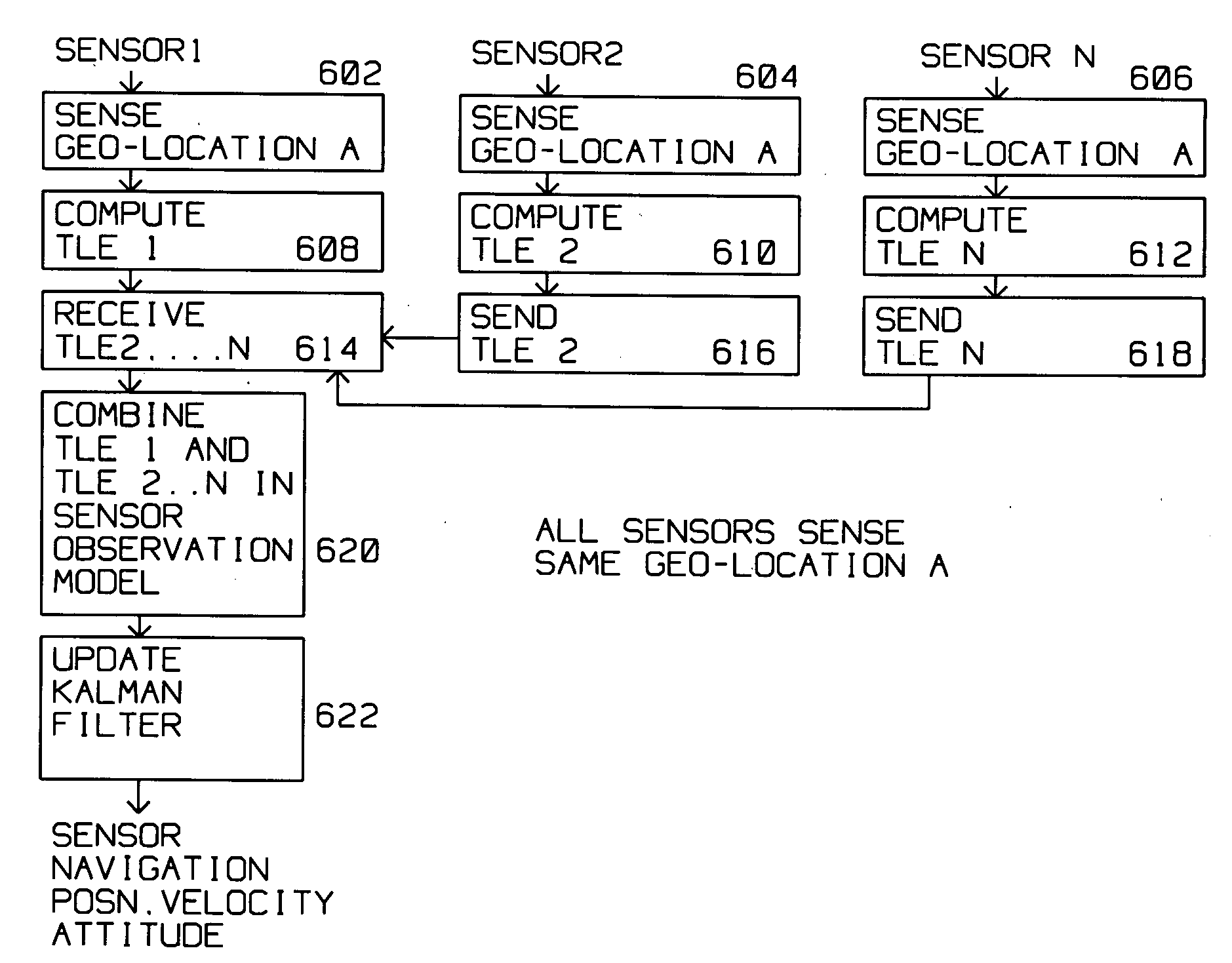
[0079] Sensor i is updated from other sensors j (≠i) at the same time where j=0, 1, . . . , n-1 for a fixed i where I=0, 1, . . . , n-1. All sensors, including sensor 0, are sensing the same geo-location A, typically a conveniently discernable target.

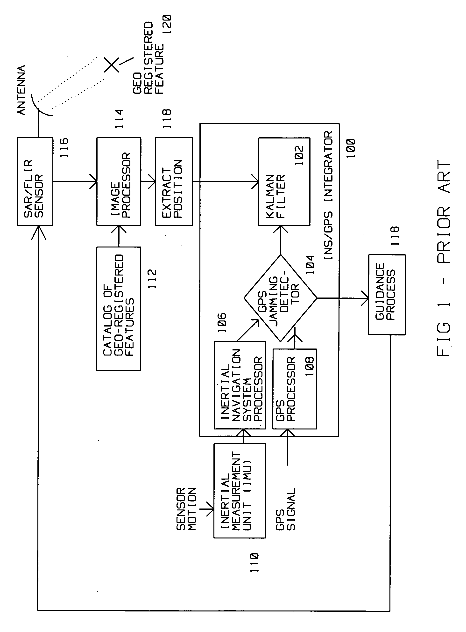
[0080] This case is illustrated in FIG. 4. Here, sensor 0400 has a GPS receiver 402 for receiving navigation signals from a constellation of GPS satellites. GPS Jamming Detector 414 detects a jammed or unavailable GPS signal. If the GPS navigation signal is valid, the GPS location information is passed to Kalman filter 412, which in turn supplies position information to Update Guidance Position, Velocity and Attitude 416 within processor 420.

[0081] Conversely, if GPS Jamming Detector 414 determines that the GPS signal is unusable, that is, jammed or corrupted, an alternative source of navigation information is activated. Inertial Navigation System SAR, FLIR Platform motion 404 determines the location of a sensor (on a platform) and ge...


PUM


Abstract

The need for geo-registered features is avoided by a system for estimating a motion of a first sensor during a time interval. The system has a second sensor where the first sensor and the second sensor sense the same geo-location during the time interval. The first sensor computes a first target location error from sensing the geo-location. The second sensor also computes a second target location error from sensing the geo-location. A data link interconnects the first sensor and the second sensor, the data link transmitting the second target location error computed by the second sensor to the first sensor during the time interval. A processor at the first sensor combines the first target location error and the second target location error in a first sensor observation model, where the sensor observation model is descriptive of the motion of the first sensor. The observation model is used with a Kalman filter to update the position of the first sensor. This combination of the first sensor observation model and the second sensor observation model generates a more accurate target location error at the first sensor. The principle is extended to a plurality of platforms.

Description

[0001] This application is a continuation in part of U.S. Patent and Trademark Office application Ser. No. 11 / 159,475, filed Jun. 23, 2005. (PD-04W243)BACKGROUND OF THE INVENTION [0002] 1. Field of the Invention [0003] This invention is in the field of improved sensor motion (position, velocity, acceleration) accuracy during GPS unavailability using multiple sensors locating a particular geo-target in a common time frame. [0004] 2. Description of the Related Art [0005] Synthetic Aperture Radar (SAR) is used for ground mapping as well as target identification. The general principle behind SAR is to coherently combine the amplitude and phase information of radar returns from a plurality of sequentially transmitted pulses. These pulses are from a relatively small antenna on a moving platform. As the platform moves, the information contained in the pulses is coherently combined to arrive at a high resolution SAR image. [0006] The plurality of returns creating a SAR image generated by th...

Claims


Application Information

Patent Timeline
IPC IPC(8): G01C21/00G01S19/09G01S5/14G01S19/46
CPCG01S7/40G01S13/9035G01S13/867G01S19/47G01S19/21G01S13/90
Inventor CHIOU, KUO-LIANGCHIOU, CARROLL C.RUDOLPH, KEVIN E.
Owner RAYTHEON CO
Why Eureka
Try Eureka