Process, system, or method for the determination of the percentage of area of a parcel of land available for development or preservation and the production of a report and map therefor on a fixed tangible medium

a technology of land use decision and percentage of area, applied in the field of land use decision system, process or method, can solve the problems of inability to efficiently combine data into a single presentation, inability to timely analyze and accurately evaluate data, and large amount of manual collection of data

Inactive Publication Date: 2006-12-28
FOLCHETTI JOHN E +1
View PDF7 Cites 64 Cited by
  • Summary
  • Abstract
  • Description
  • Claims
  • Application Information

AI Technical Summary

Benefits of technology

[0037] IT IS THEREFORE AN OBJECT of the present invention to allow for a timely, inexpensive and totally

Problems solved by technology

The quantity and size of these land use constraints can and usually do result in significant land use decisions regarding a wide variety of potential uses for any given area of land.
Prior to the advent of computers, the LUP's collection of the data necessary for the evaluation process of any given parcel or area of land was extremely time consuming, expensive, and subjective.
The majority of the data had to be collected manually and could not be efficiently combined into a single presentation for timely analysis, accurate evaluation and correct decision making.
Certainly, the data could not be efficiently combined into a single presentation for timely analysis, accurate evaluation and correct decision making, even before the LUP had made the initial investment in the given parcel or area of land.
Such decision was made at a great risk and burden to the LUP because the LUP's decision depended on the subjective opinion of the individual performing the walk through.
If the individual conducting the walk-through was wrong in his or her opinion of how much land was subject to land use constraints, the LUP could potentially incur significant liability, along with time and economic loss.
Both of these processes were and still are expensive and time consuming, particularly if they in

Method used


Image

  • Process, system, or method for the determination of the percentage of area of a parcel of land available for development or preservation and the production of a report and map therefor on a fixed tangible medium
  • Process, system, or method for the determination of the percentage of area of a parcel of land available for development or preservation and the production of a report and map therefor on a fixed tangible medium
  • Process, system, or method for the determination of the percentage of area of a parcel of land available for development or preservation and the production of a report and map therefor on a fixed tangible medium

Examples


Embodiment Construction

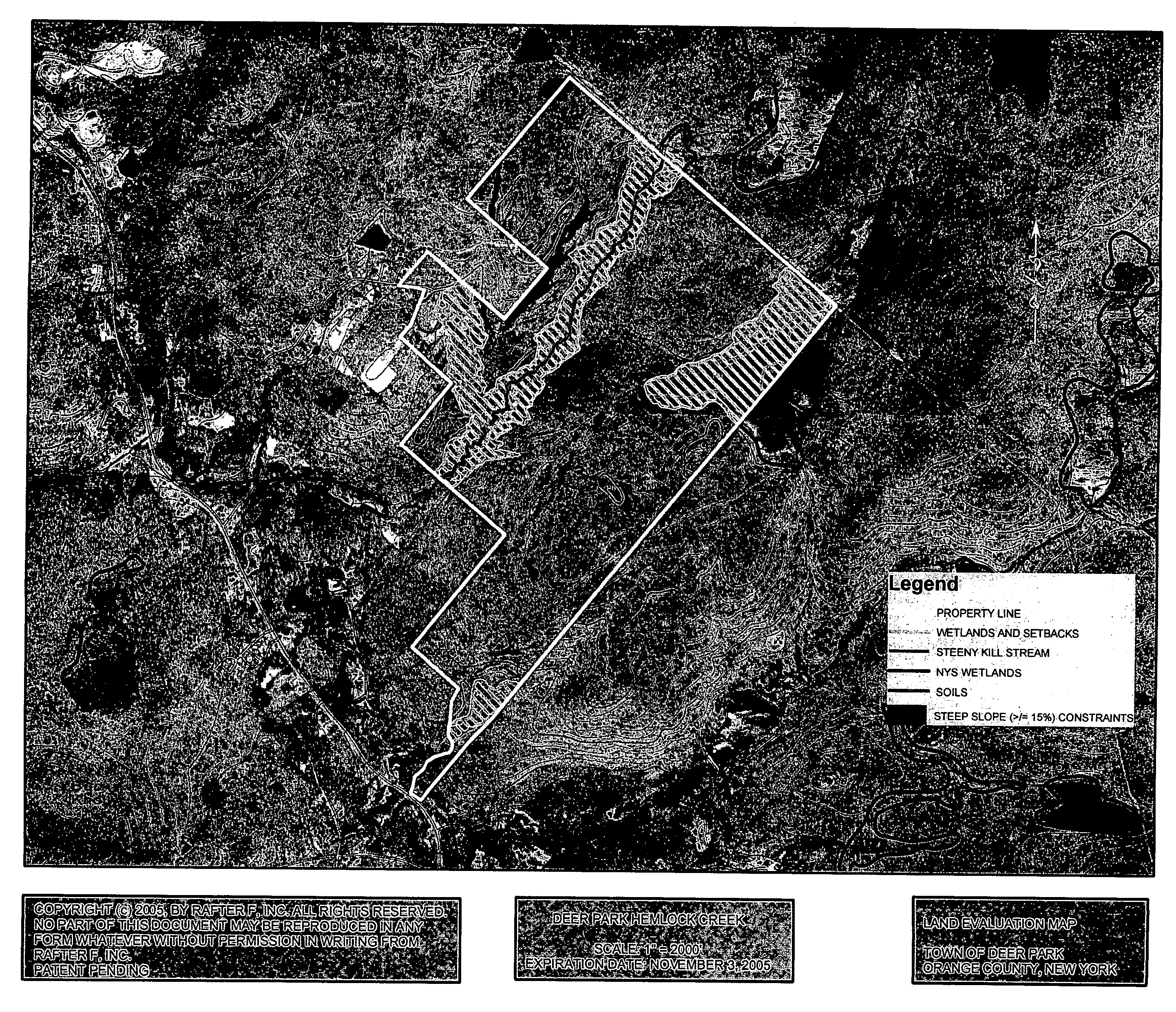
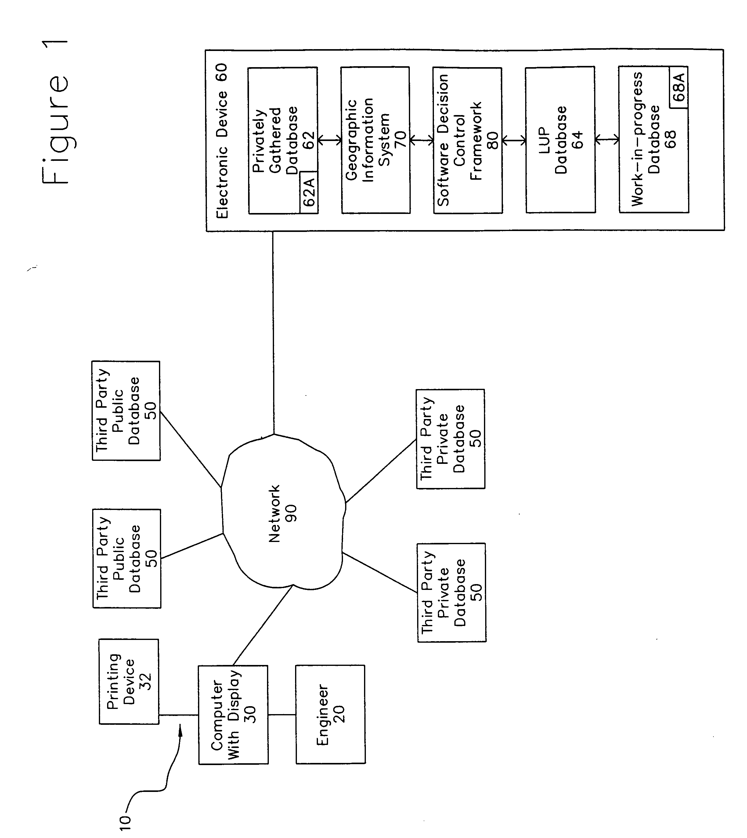
[0056] Referring more specifically to the drawings, FIG. 1 generally depicts the inventive method, process or system for an early determination of the best uses of an area of land or parcel, via the identification and quantification of various physical, geographic, geologic, hydrogeologic, edaphic and flora parameters and constraints present in the area of land and the production of a report and map therefor on a fixed tangible medium at 10. It is designed to antecede, if not completely replace the visual survey and walk-through of the early evaluation process of a parcel of land, and provide LUPs with the ability to develop an understanding of the scope of land use constraints thereof, early enough, and make a decision about the parcel of land before exposing themselves to great risk or investing great time, financial resources and effort.

[0057] It does so by providing a structured framework for the evaluation of (i) whether the land use constraints in a particular area of land or...


PUM


Abstract

A system for the determination of the percentage of area of a parcel of land available for development or preservation which comprises at least one privately gathered data base having at least one file relating to at least one geographic area and its privately gathered corresponding map, physical, geographic, geologic, edaphic, and flora parameters present in and relating to said geographic area; a Software Decision Control Framework connected to the privately gathered data base; a Geographic Information System connected to and interacting with both the Software Decision Control Framework and the privately gathered data base; a network connected and interfaced to the Software Decision Control Framework and at least one data base interfaced with the network, the data base comprising physical, geographic, geologic, edaphic and flora parameters present in and relating to various geographic areas worldwide, whereby the Software Decision Control Framework interacts with the privately gathered data base, the Geographic Information System, the network and the database to provide an evaluation report which identifies, quantifies and establishes the percentage of area of the parcel of land for development and preservation in conformance to local, federal and state land use regulations and non-governmental land use policies.

Description

BACKGROUND OF THE INVENTION [0001] 1. Field of the Invention [0002] The present invention generally relates to a land use decision system, process or method. More particularly, the present invention relates to a geographic information / data management / data analysis system, encompassing physical, geographical criteria, including edaphic and floral data pertinent to land use decisions (hereinafter “land use constraints”), for the purpose of: (a) thoroughly mapping a particular land area; (b) identifying and quantifying the fractions of the land area that exhibit land use constraints; c) identifying and quantifying those fractions of the land area that are actually free of land use constraints, and (d) establishing the optimum use thereof in conformance to local, federal and state land use regulations and non-governmental land use policies; all before significant cost and expense is incurred and a land use decision is actually made. [0003] 2. Description of the Prior Art [0004] There ar...

Claims


Application Information

Patent Timeline
IPC IPC(8): G06F17/30
CPCG06Q40/025G06Q30/00G06Q40/03G06Q50/02
Inventor FOLCHETTI, JOHN E.FOLCHETTI, J. ROBERT
Owner FOLCHETTI JOHN E
Why Eureka
Try Eureka