System and method for predicting travel time for a travel route

a technology of travel route and system, applied in the field of system and method for predicting travel time for a travel route, can solve the problems of imposing certain communications restrictions, limited amount, complexity and size of encoding,

Inactive Publication Date: 2007-01-18
UBER TECH INC
View PDF47 Cites 66 Cited by
  • Summary
  • Abstract
  • Description
  • Claims
  • Application Information

AI Technical Summary

Benefits of technology

[0230] Another advantage of the present invention is that the incident databases gradually increase in accuracy as more and more incidents are processed: subsegments are being continuously created and the matching of incidents becomes increasingly flexible.
[0231] In Step 320, the system 10 examines the next user from the list of users subscribed for alerts relating to the matched segment. If there is no more user subscribed for the matched segment, the process ends.
[0232] In Step 322, if the severity of the present incident matches the level of severity that the user has requested for the segment (specifically, if the severity number is lower, as lower numbers correspond to more severe incidents in the present invention) the system 10 proceeds to Step 324 and otherwise the system returns to Step 320.
[0233] In Step 324 the system 10 examines the predicted window of time for the incident, and determines if there is any intersection between the predicted window of time for the incident and the window of time the user watches the segment for. This is preferably performed by making comparisons of precedence between dates. Determining whether two windows of time overlap is analogous to determining whether two linear segments overlap in one dimension, and the techniques are generally known.
[0234] If the two windows of time overlap, the system 10 proceeds to Step 326, and otherwise the system 10 returns to Step 320.
[0235] In Step 326 the system 10 prepares a message by means of compiling and especially abbreviating the Information, and dispatches a message to the user on the user preferred address.

Problems solved by technology

This is due to the limited amount of data involved in each transmission, such as a list of incidents, traffic speed and congestion information at specific locations.
Such servers may be potentially shared by several companies, and may impose certain communications restrictions, for reasons such as efficiency and security.
In practice there is a trade-off between the speed and efficiency that is required to match information to subscribers and the complexity and size of the encoding.
The problems with this conventional method is that the direction of travel is not taken into account, as well as the interference between segments on unrelated routes that are close in latitude and longitude.
These programs, however, typically do not fetch the data through the Internet but rather look periodically if new data was deposited / made available on the server.
In case the end time is at a date too far remote in the future, such as more than two days after the current time, this is assumed to be an error in the data, except when the incident is ROAD WORK.
This test limits the risk of a data source automatically generating an excessive number of corrections within a few minutes; which could result in a large number of updates being dispatches to subscribers, with very few changes in the Information actually conveyed.
B=Average number of incidents reported at any given time in the past hour C=Average number of incidents published at any given time in the past hour: A number equal to zero would mean that the publishing side is completely devoid of data, which would certainly be indicative of a technical problem.
If G is low but D is high, there is an indication of problems on the server / publishing side.
For example, if a user were informed that there exists a particular traffic condition on State Highway 160, this information is generally useless absent some sort of relative positional context.

Method used


Image

  • System and method for predicting travel time for a travel route
  • System and method for predicting travel time for a travel route
  • System and method for predicting travel time for a travel route

Examples


example congestion

[0050] Example Congestion Data (CALTRANS)

Sensor IDTime ReadSpeedCongestion221903:34:03 AM472

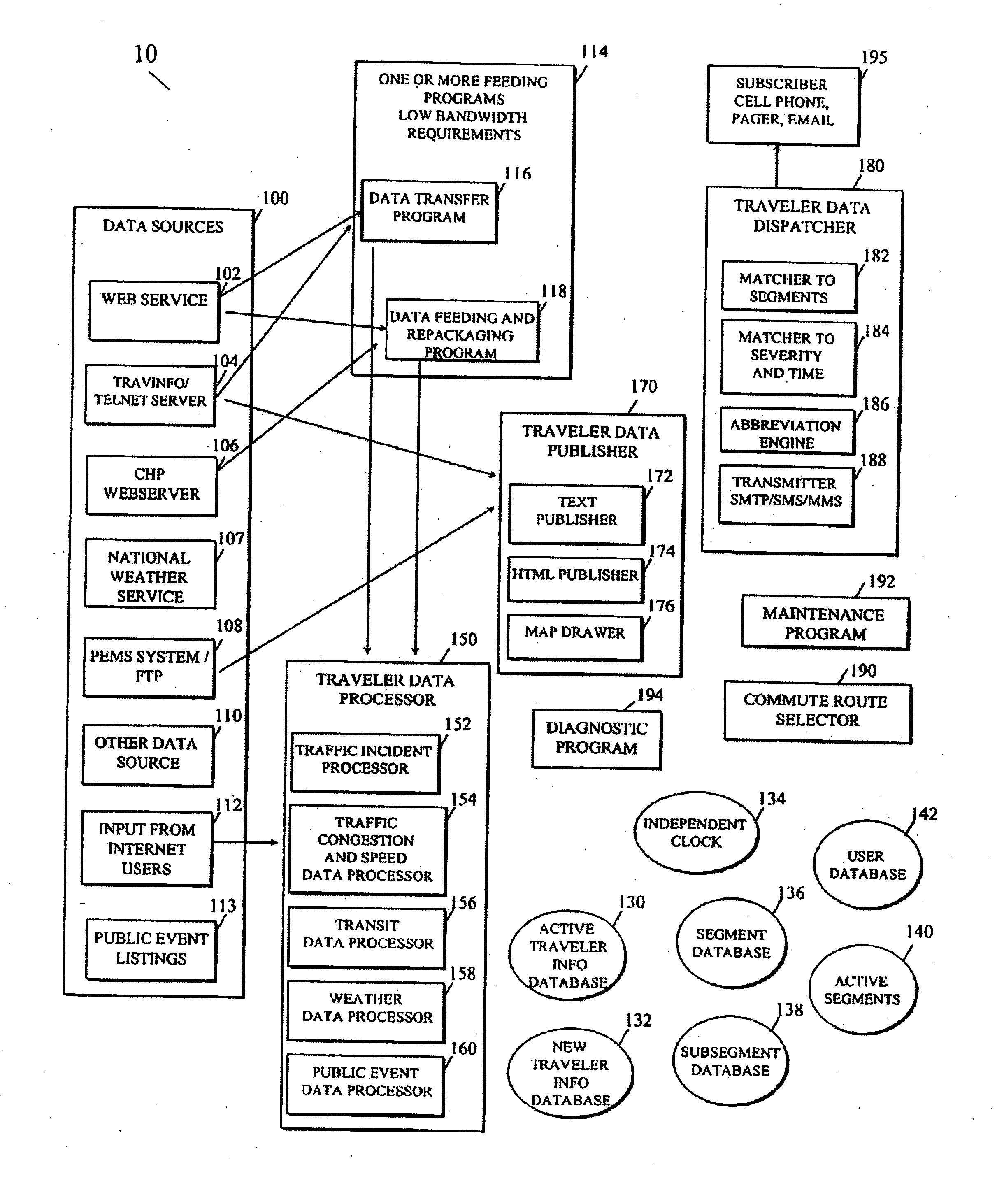
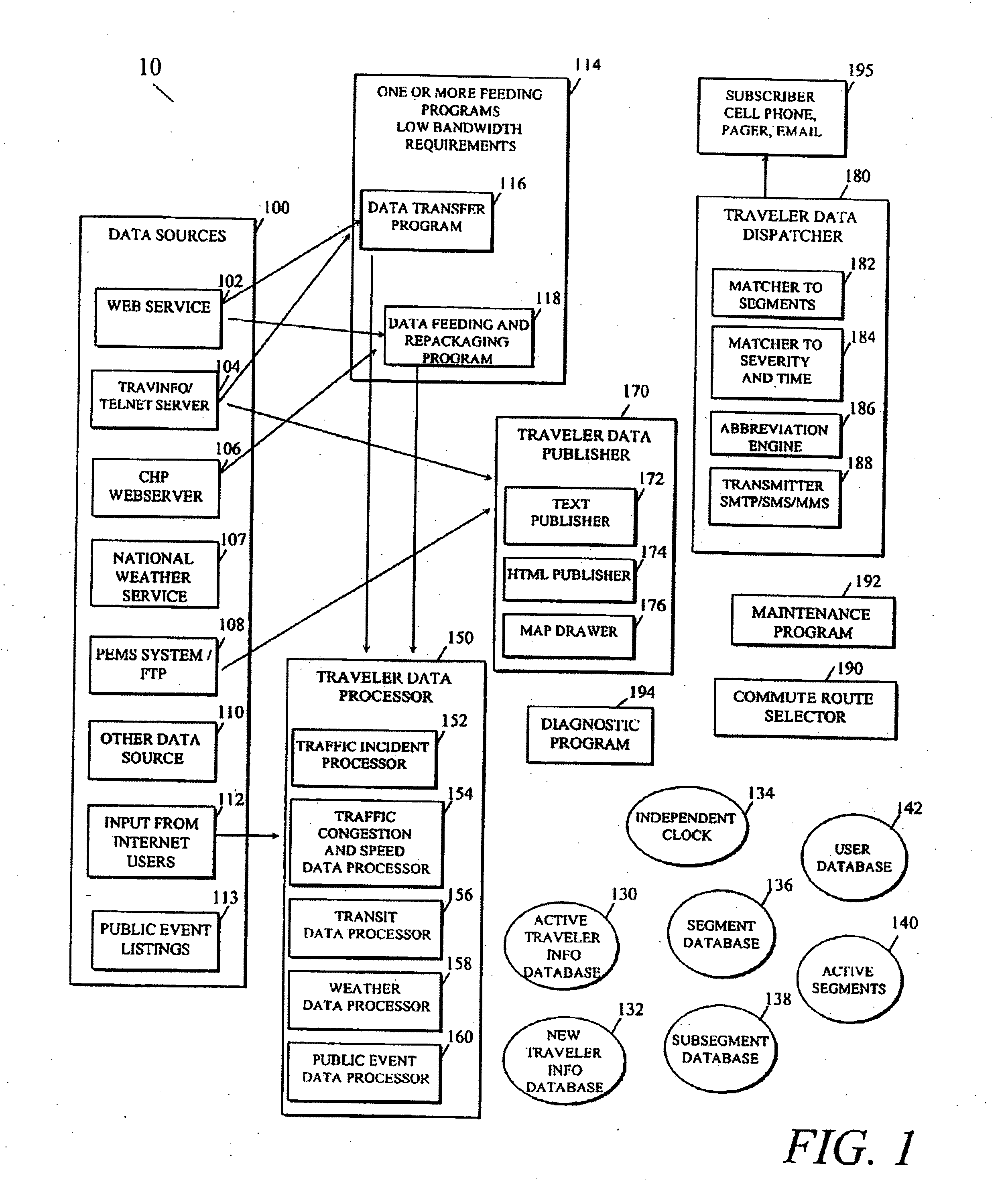
[0051] It should be apparent that the input data inevitably contains differing content. For example, one Data Source 100 may report a location in terms of a street address, another Data Source 100 may report the same incident, having the location in terms of an equipment identification number, such as a sensor, while another Data Source 100 may report location in geographic terms, such as latitude and longitude. Therefore, standardization of data as the data is collected is required to ensure integrity of the TIDS 10.

[0052] Referring also to FIG. 1, the Traveler Information Dissemination System (TIDS) 10 includes one or more Feeding Programs 114. The Feeding Programs 114 may be Data Transfer Programs 116, or Data Feeding and Repackaging Programs 118. The Feeding Program Subsystem 114 is responsible for fetching the data from the different Data Sources 100, converting the data to a common for...

first embodiment

[0121] Active Segment 140 are preferably stored by referencing the ID of the segment and the window of time the segment is being watched by a subscriber. In a first embodiment, each segment ID with at least one subscriber watching is stored as a file on disk that can be quickly retrieved by the operating and file system of the computer once equipped with only a file name.

[0122] Hash-tables may be also be used in an alternate embodiment instead of files. Hash-tables reside in main memory instead of on the hard disk. A database system such as Oracle or Microsoft SQL Server or Microsoft MSDE may be used as well.

[0123] For example, a segment ID may be 9000 for a given segment, or 1 for a public place, where public events affecting travelers may occur. In practice, one operational system includes about 10,000 segments correlated to San Francisco Bay Area highways and about 20 public places, such as 3COM Stadium, PACBELL Park, and the SHORELINE Amphitheater.

[0124] An example of the syst...


PUM


Abstract

A system for predicting a travel time for a traffic route is disclosed. The traffic route comprises one or more road segments. A predicted travel time for each of those segments is calculated based, in part, on traffic speed data for each of the one or more road segments. A total travel time is then calculated for the route, the total travel time including a predicted travel time for each of the one or more road segments

Description

CROSS REFERENCE TO RELATED APPLICATIONS [0001] This application is a continuation and claims the priority benefit of U.S. patent application Ser. No. 11 / 302,418 filed Dec. 12, 2005 and entitled “Three-Dimensional Traffic Report,” which is a continuation-in-part and claims the priority benefit of U.S. patent application Ser. No. 11 / 253,301 filed Oct. 17, 2005 and entitled “System for Aggregating Traveler Information,” which is a divisional and claims the priority benefit of U.S. patent application Ser. No. 10 / 379,967 filed Mar. 5, 2003 and entitled “Personalized Traveler Information Dissemination System,” which claims the priority benefit of U.S. provisional patent application No. 60 / 362,155 filed Mar. 5, 2002 and entitled “Personalized Road Traffic Information Dissemination”; U.S. patent application Ser. No. 11 / 302,418 also claims the priority benefit of the following U.S. provisional patent applications: U.S. provisional patent application No. 60 / 634.951 filed Dec. 10, 2004 and ent...

Claims


Application Information

Patent Timeline
Patent Type & Authority Applications(United States)
IPC IPC(8): G08G1/09H04H20/00H04W4/029
CPCG01C21/3492G01C21/3694G08G1/096716G08G1/096741G08G1/096775G01C21/3407G08G1/096827G08G1/096866G08G1/096888G08G1/0967G08G1/093G08G1/096816H04W4/029H04W4/025G06N5/04G08G1/09675G01C21/36G08G1/0125H04B1/3822G01C21/30G08G1/0129G08G1/096822
Inventor GUEZIEC, ANDRE
Owner UBER TECH INC
Why Eureka
Try Eureka