Navigation system utilizing XML/SVG map data converted from geographic map data and layered structure of XML/SVG map data based on administrative regions

a navigation system and geographic map technology, applied in the field of navigation system utilizing xml/svg map data converted from geographic map data and layered structure of xml/svg map data based on administrative regions, can solve the problems of increasing the conversion time and labor, not always well suited for a navigation system, and increasing the chances of causing inconsistencies between adjacent meshed portions, etc., to achieve the effect of reducing the time required for data conversion and easy modification

Active Publication Date: 2007-08-09
ALPINE ELECTRONICS INC
View PDF10 Cites 41 Cited by
  • Summary
  • Abstract
  • Description
  • Claims
  • Application Information

AI Technical Summary

Benefits of technology

[0012]It is a further object of the present invention to provide a method of utilizing the map data in the XML / SVG by a navigation system so that the map data can be easily modified and updated since the XML / SVG map data is human-readable and recognizable text data.
[0013]It is a further object of the present invention to provide a method of producing the map data for use with a navigation system by directly converting the GDF format map data to the XML / SVG format map data, thereby dramatically decreasing the time required for data conversion.
[0018]According to the present invention, the navigation system utilizes the XML / SVG format map data converted from the GDF format map data. Thus, the map data can be easily modified and updated since the XML / SVG map data is human-readable and recognizable text data. Further, in the present invention, by directly converting the GDF format map data to the XML / SVG format map data, the time required for data conversion can be dramatically decreased. The map data in the XML / SVG format is constructed in a layered structure which is created based on administrative regions such as states, counties and cities. Further, the map data in the XML / SVG format is suitable for transmission through the communication system such as Internet, thus, the user is able to retrieve the desired map data from the remote data server through the communication system.

Problems solved by technology

Since the GDF is created as a map data file to simply describe the topological structures, it is not always well suited for a navigation system unique to a particular manufacturer of the navigation systems.
Since the GDF format file has disadvantages that it is difficult to modify its data contents, in the conventional technology, the GDF format is converted to a file format, for example, PSF (physical storage format), to actually use the map data in a navigation system.
This requires additional processes of data conversion and calculation, which increases the conversion time and labor.
Further, because the map area is divided into a plurality of meshed portions 61, the chances of causing inconsistencies between adjacent meshed portions 61 would increase, which is undesirable since the accuracy of the map would be deteriorated.
Moreover, because the format of the PSF map data is fundamentally different from that of the GDF map data, the process to convert the GDF map data into the PSF map data is extremely complex and time consuming.
For example, in the case where the map data overs a large area such as the whole north America, the process for conversion can take several weeks.
Other disadvantage associated with the PSF map data in the conventional technology is its inflexibility and lack of expandability.
In addition, because the PSF data is machine dependent, recompilation of the data would be necessary if different hardware or software is to be used or an existing navigation system is changed or modified.

Method used


Image

  • Navigation system utilizing XML/SVG map data converted from geographic map data and layered structure of XML/SVG map data based on administrative regions
  • Navigation system utilizing XML/SVG map data converted from geographic map data and layered structure of XML/SVG map data based on administrative regions
  • Navigation system utilizing XML/SVG map data converted from geographic map data and layered structure of XML/SVG map data based on administrative regions

Examples


Embodiment Construction

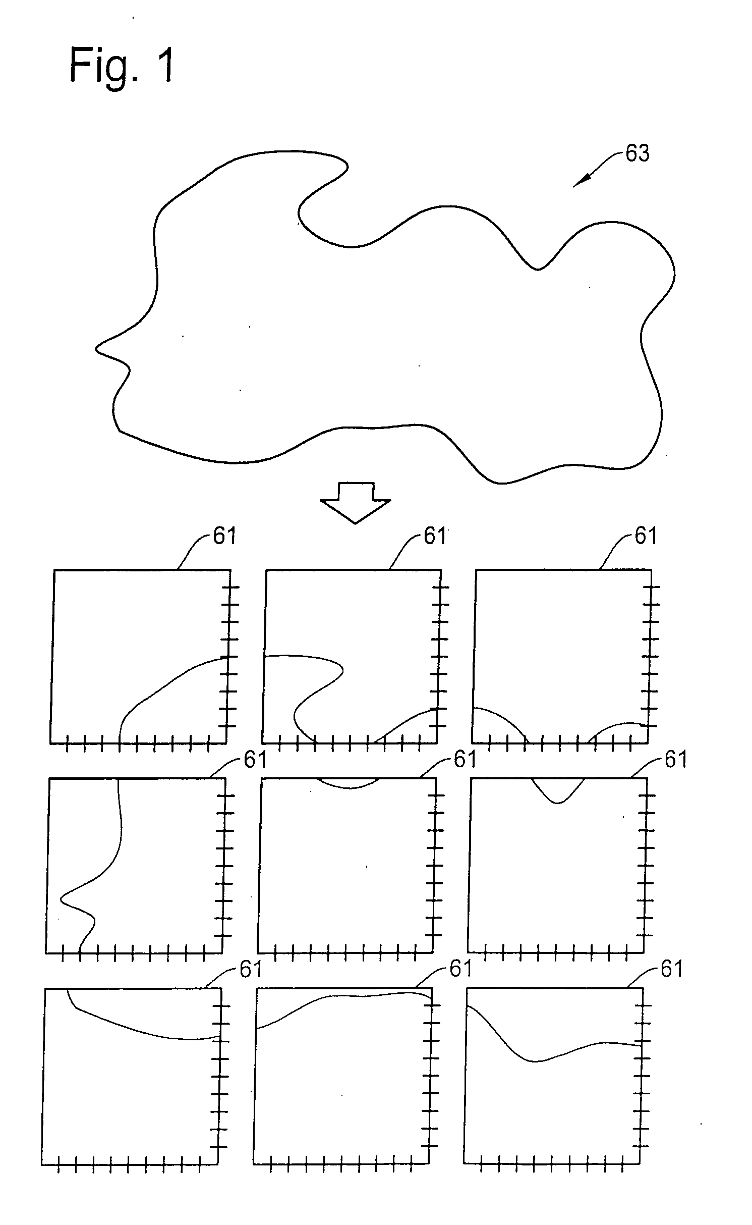
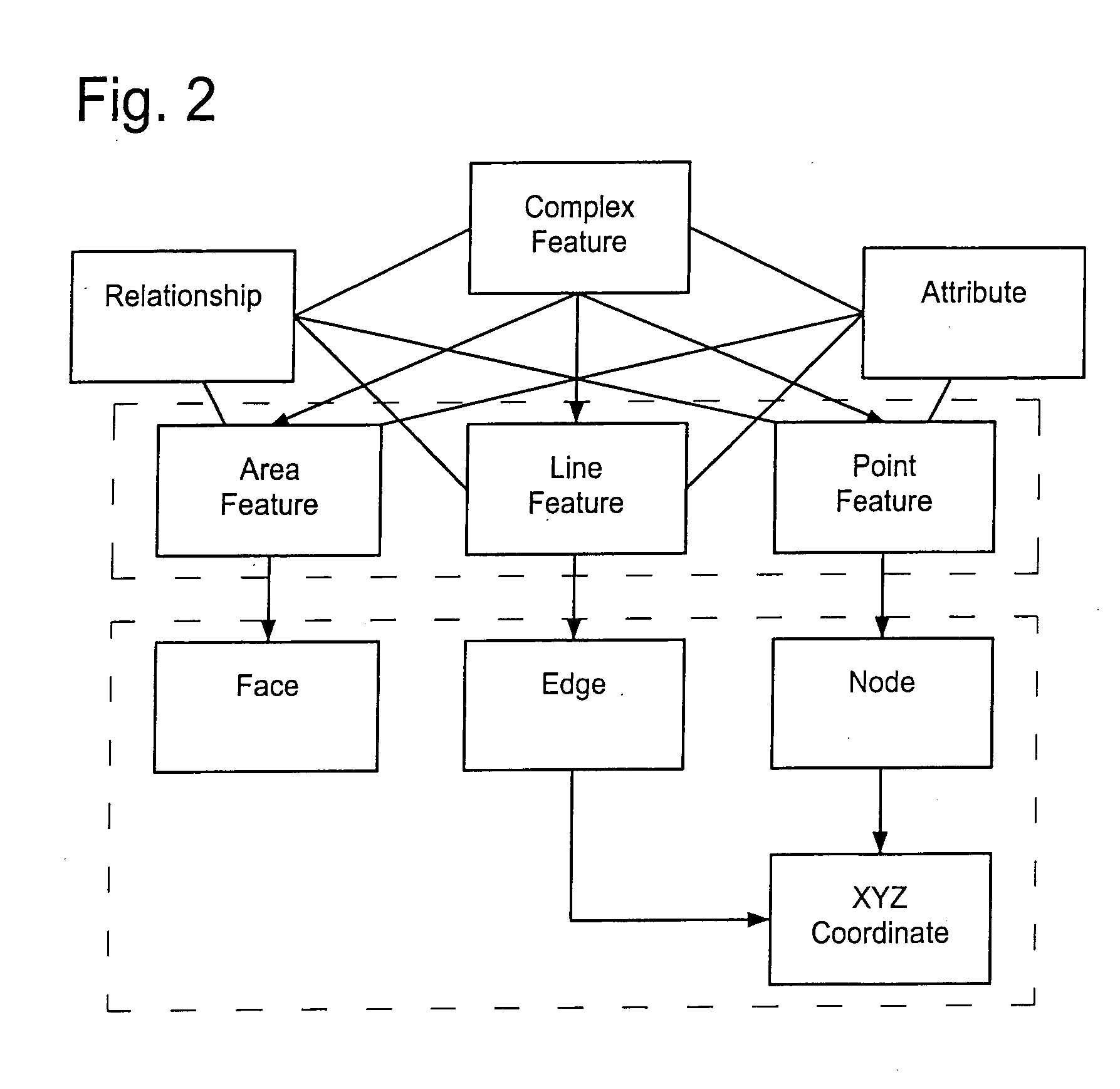
[0036]The navigation system of the present invention will be described in more detail with reference to the accompanying drawings. The navigation system of the present invention utilizes map data in an extensible markup language (XML) and scalable vector graphics (SVG) format converted from geographic data such as GDF (geographic data file). The map data in the XML / SVG format for the navigation system is further constructed in a layered structure, i.e., having a plurality of different levels, based on administrative jurisdictions such as cities, counties, and states.

[0037]It should be noted that although the present invention will be described for the case of converting the GDF map data to the XML / SVG map data for an illustration purpose, geographic data other than GDF can also be used in the present invention. It should also be noted that the specific names, XML and SVG, are used in the present invention for describing the languages or formats of the map data only for an illustrati...


PUM


Abstract

A navigation system uses XML / SVG format map data for achieving flexibility in modifying the map data. A method of converting geographic data into the XML / SVG format map data includes the steps of retrieving the geographic data, analyzing the retrieved geographic data for its data elements structure, data type and semantics, and converting the analyzed data to the XML / SVG format map data for with the navigation system. The XML / SVG format map data is constructed in a layered structure created based on administrative regions such as states, counties and cities. The XML / SVG format map data can be delivered to a remote user as a unit of administrative region through a communication network.

Description

FIELD OF THE INVENTION[0001]This invention relates to a navigation system utilizing XML / SVG format map data converted from generally available geographic data and to a layered structure of the XML / SVG format map data created on the basis of administrative regions such as cities, counties, and states.BACKGROUND OF THE INVENTION[0002]A navigation system performs travel guidance for enabling a user to easily and quickly reach the selected destination. A typical example is a vehicle navigation system where a vehicle is equipped with a navigation function to guide a driver to a destination through a calculated route. Such a navigation system detects the position of the user's vehicle, and reads out map data pertaining to an area at the current vehicle position from a data storage medium, for example, a CD-ROM (compact disc read-only memory), a DVD (digital versatile disc), or a hard disc. Typically, the navigation system displays a map image on a monitor screen while superimposing thereo...

Claims


Application Information

Patent Timeline
Patent Type & Authority Applications(United States)
IPC IPC(8): G01C21/32
CPCG01C21/32G01C21/3881G01C21/3878
Inventor MOTOYAMA, MASAKIYAMAGUCHI, HIROHISA
Owner ALPINE ELECTRONICS INC
Why Eureka
Try Eureka