Enhancement of GNSS position determination in poor signal propagation environments

a technology of signal propagation environment and position determination, applied in the field of gnss systems, can solve the problems of degrading the solution is not suitable for some small rovers, and achieve the effects of improving the geometry of the solution of the rover, and improving the accuracy of position determination

Active Publication Date: 2007-10-18
NOVATEL INC
View PDF8 Cites 13 Cited by
  • Summary
  • Abstract
  • Description
  • Claims
  • Application Information

AI Technical Summary

Benefits of technology

[0007]Each rover receives the ranging signal from the base station and aligns its code generator and carrier phase with that signal. If a rover can process signals from only three satellites, the base station serves as a ranging transmitter which is synchronous with the satellite system and, thus, serves as the required fourth satellite for a complete determination of the rover's position. Even if the rover can process the signals from four or more orbiting satellites, signals from the base station enhance the rover's position determinations, as set forth hereinafter.
[0010]The base station also broadcasts in its transmissions information about the GPS (or like) satellite signals, including identification of the satellites within its view, Doppler offsets of the signals from those satellites, messages transmitted by the satellites and other information that may be useful in processing satellite signals. This will assist the rovers in acquiring and tracking the satellite signals even in very weak-signal environments. The information will also permit the rovers to improve their positional accuracies as is known in the art. This information may be broadcast by modulation of the broadcast ranging signal.
[0011]A further advantage of a terrestrial source for ranging information is that it provides better geometry in the rovers' solutions. This is because the rovers are typically attempting to solve for the independent variables of height and receiver clock error, as well as longitude and latitude, from measurements that are mainly in the vertical direction, since the satellites are always above the rovers. The mathematics has difficulty separating the contributions of the height and receiver clock error parameters and, as a result, the estimates of these parameters are inaccurate as compared with those of the horizontal components (latitude and longitude). The clock and height errors are typically two to three times worse than the errors in estimating the horizontal components of the rover's position. The addition of the terrestrial source ranging measurement into the equations for rover position is used to separate the height and clock errors, which provides for more accuracy in position determination.
[0012]The clock error can also be independently determined using only TWTT from the base station and, therefore, the clock error can be removed from the list of unknown parameters. With an accurate estimate of the receiver clock error, the rover's height component estimate will become more accurately observable from the satellite signals. This would be extremely useful for applications requiring accurate height determination such as, for example, earth excavation and road paving, and is a distinct advantage in cost savings and ease of use over systems that, for example, determine height using lasers.

Problems solved by technology

At times a rover may enter an area where trees and / or various other objects impede the signal reception from some of the satellites, thus degrading the accuracy of position determination.
Various arrangements have been used to cope with this problem in automobiles, for example, but these solutions are not suitable for some small rovers, such as golf carts moving over golf courses because of, for example, associated costs and complexities.

Method used


Image

  • Enhancement of GNSS position determination in poor signal propagation environments
  • Enhancement of GNSS position determination in poor signal propagation environments
  • Enhancement of GNSS position determination in poor signal propagation environments

Examples


Embodiment Construction

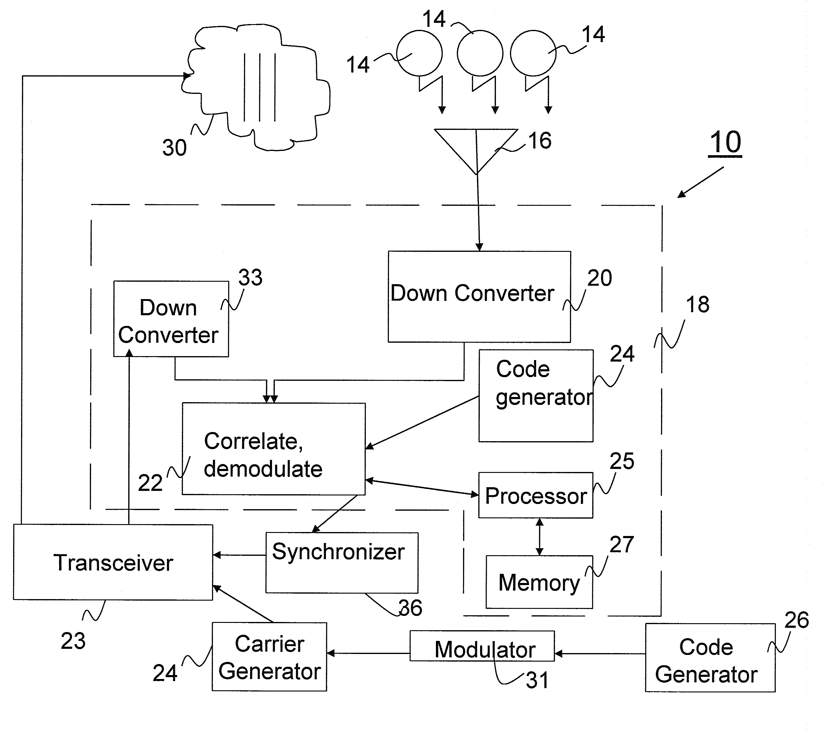
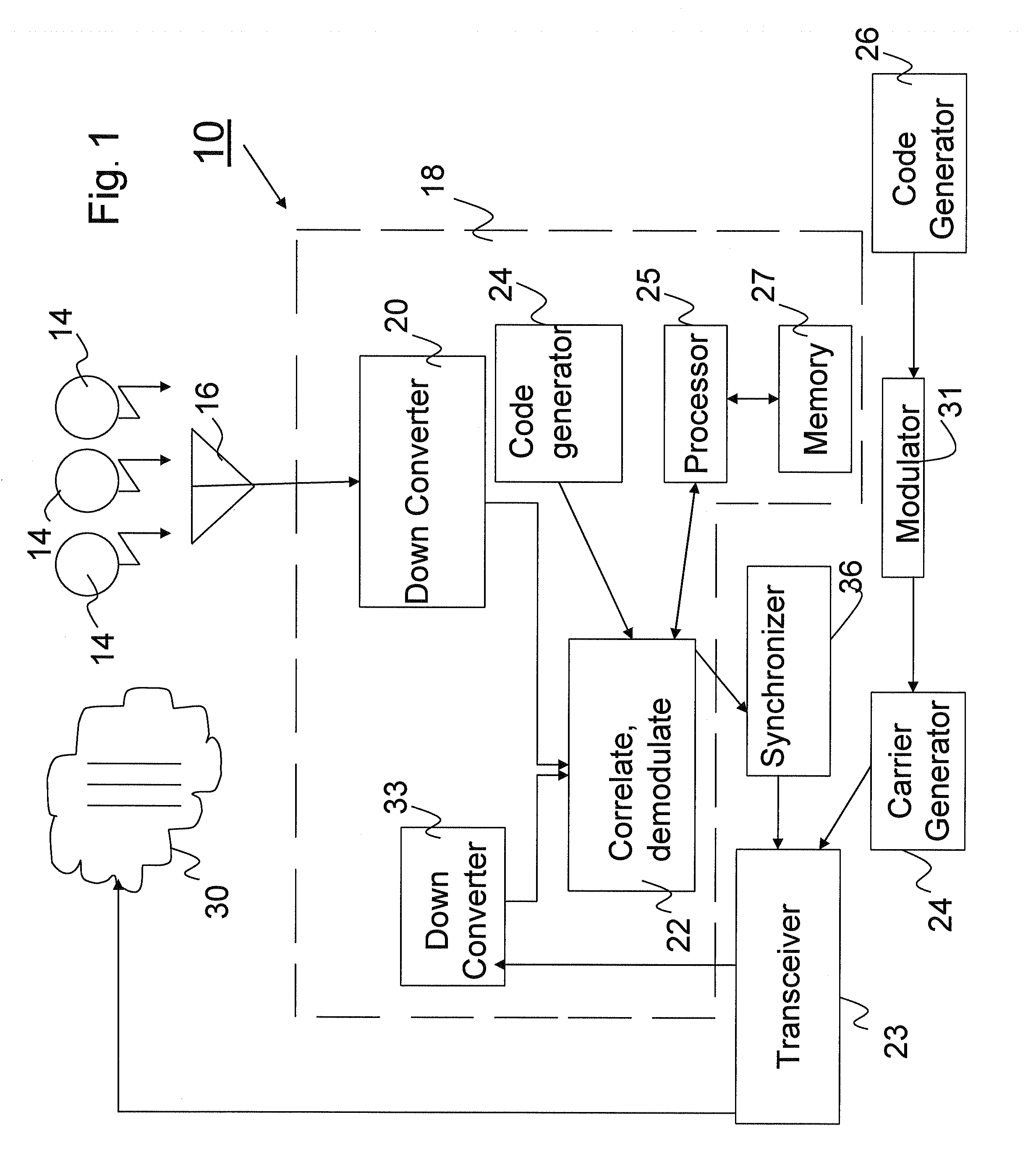
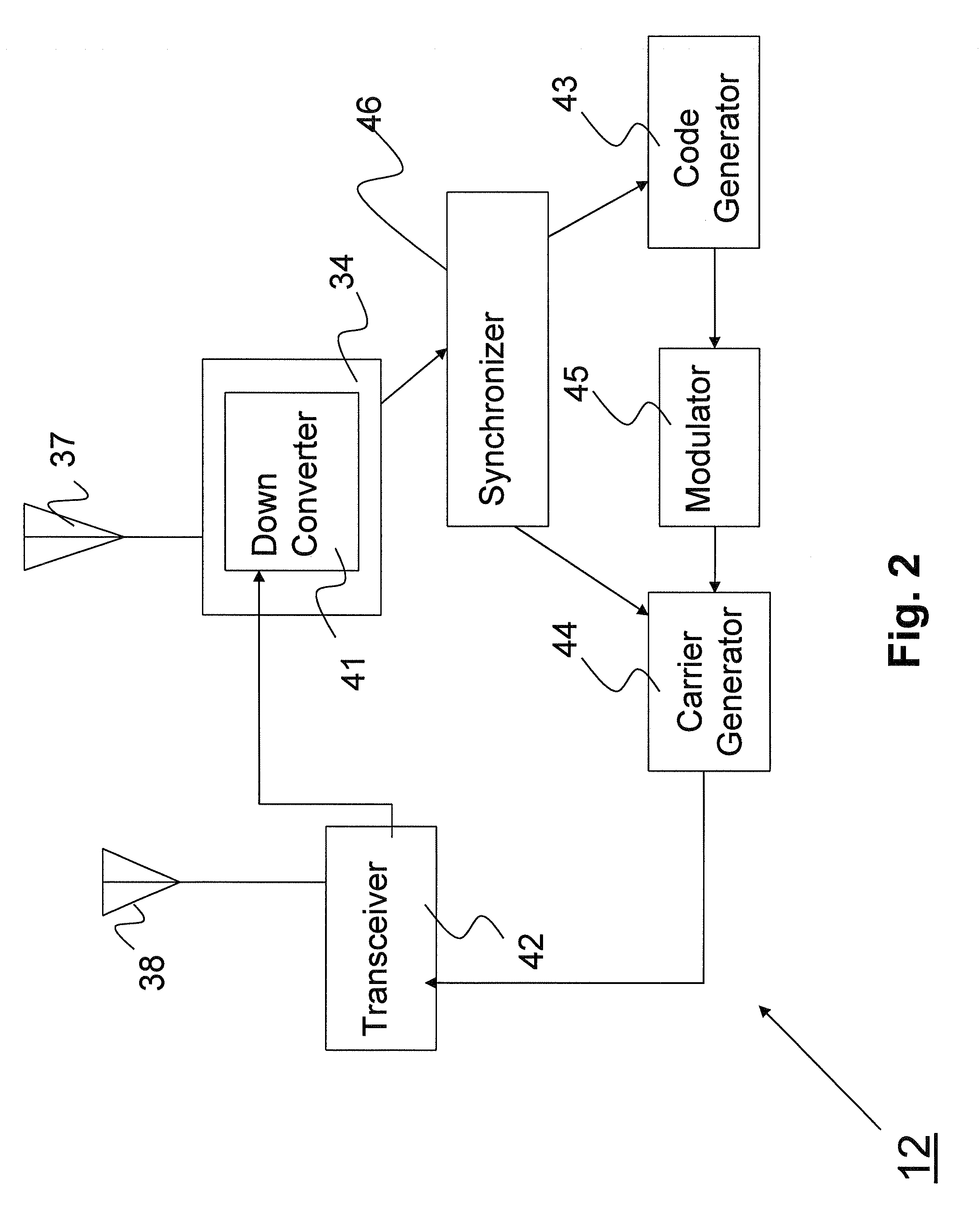
[0016]FIG. 1 depicts a base station, generally indicated at 10, that operates in conjunction with rovers 12, one of which is depicted in FIG. 2. Both the base station and the rovers make use of the ranging signals transmitted by a plurality of Earth-orbiting satellites 14.

[0017]The base station 10 includes an antenna 16 that picks up the signals from the satellites and passes them to a GNSS receiver 18. The receiver includes a down converter 20 that translates the satellite signals to an intermediate frequency. The down converter 20, a correlation and demodulation unit 22 and a code generator 24 are connected in a well known manner to synchronize carrier phase and the local codes produced by the code generator to the carrier and codes used by the individual satellites 14, and ultimately provide the position of the base station. The base station includes a processor 25 and an associated memory 27 containing software enabling the processor to perform the functions set forth above, as ...


PUM


Abstract

A system, for enhancing location estimates by movable rovers that use receivers for processing ranging signals from orbiting satellites, including a fixed base station that serves as a ranging signal source for the rovers' receivers. The base station may also determine and transmit the azimuthal angles of the respective rovers. The rovers use this information, along with a calculated or transmitted ranges to the base station to calculate the ranging system times at the locations of the rovers. Further, the rovers may use the information along with signals from satellites in view to determine position.

Description

CROSS-REFERENCE TO RELATED APPLICATION[0001]The present application claims the benefit of U.S. Provisional Patent Application Ser. No. 60 / 787,428, which was filed on Mar. 30, 2006, by Walter J. Feller for ENHANCEMENT OF GPS POSITION DETERMINATION IN POOR SIGNAL PROPAGATION ENVIRONMENTS and is hereby incorporated by reference.FIELD OF THE INVENTION[0002]This invention relates generally to GNSS systems and, in particular, to an improvement in position information acquired by a movable GNSS receiver.BACKGROUND INFORMATION[0003]In the following description the term “rover” is applied to moveable receivers, whether they are attached to moving rovers or are otherwise moved about from time to time.[0004]In some applications it is desirable for rovers to monitor their positions and this is usually accomplished by receivers, e.g., GPS or GLONASS receivers, which calculate their positions by means of ranging signals transmitted by earth-orbiting satellites. To provide a position determination...

Claims


Application Information

Patent Timeline
Patent Type & Authority Applications(United States)
IPC IPC(8): G01S5/14G01S19/44G01S19/05G01S19/06G01S19/12G01S19/23G01S19/25
CPCG01S19/05G01S19/06G01S19/256G01S19/23G01S19/25G01S19/12G01S19/46
Inventor FELLER, WALTER J.
Owner NOVATEL INC
Why Eureka
Try Eureka