System and method for positioning in configured environments

a technology of configuration environment and positioning system, applied in direction finders using radio waves, instruments, etc., can solve the problems of difficult to operate high-power transmitters on orbit, difficult to operate positioning receivers in obstructed environments, and weak satellite-based navigation system signals, etc., to achieve rapid deployment, simple implementation, and cost-effective

Active Publication Date: 2007-11-08
TELECOMM SYST INC
View PDF54 Cites 110 Cited by
  • Summary
  • Abstract
  • Description
  • Claims
  • Application Information

AI Technical Summary

Benefits of technology

[0039] The resulting alternative embodiments of the present invention overcome the disadvantages associated with current systems and methods and provide a cost effective, simple to implement and rapidly deployable system with a complete stand alone method for physical state estimation using either local area beacons and / or wide area GNSS satellites such as GPS.

Problems solved by technology

Despite its many advantages, GNSS has one significant drawback: satellite-based navigation systems signals are typically very weak as they reach the positioning receiver.
In some cases, like the GPS, this is a key part of its design, but practically it is difficult to operate high power transmitters on orbit.
These weak signals make it difficult to operate positioning receivers in obstructed environments, such as indoors, as the obstructions will tend to attenuate the signal power and render it useless for positioning or, at the very least, substantially degrade the overall measurement capability.
While significant effort has been made to overcome these limitations, particularly Assisted GPS and High-Sensitivity GPS, in practical teens meter level positioning in obstructed environments using GNSS is not feasible for broad usage.
While promising, RTLS systems are very expensive to install and operate.
When high accuracy is needed, the cost and complexity of the equipment can make it all but impractical except for a few limited applications.
RTLS offers a variety of solutions that can be tailored to fit a variety of applications; however, when compared to the relative simplicity and wide availability of GNSS based positioning they all are less than desirable.
Further, for combined applications requiring positioning in both local area obstructed and wide area unobstructed environments, options are extremely limited as neither GNSS nor RTLS can satisfy the requirement alone.
Combined RTLS and GNSS systems are impractical due to the fact that they are largely incompatible and are difficult to integrate and, as a result, very expensive.
While attractive in concept, these solutions are at best too expensive and power intensive to be practical in addressing many of the RTLS applications and at worst they are illegal to operate in much of the world as they tend to jam normal GPS operations.

Method used


Image

  • System and method for positioning in configured environments
  • System and method for positioning in configured environments
  • System and method for positioning in configured environments

Examples


Embodiment Construction

[0063] There are situations in which a GNSS implementation for determining the physical state of some sensor is impractical because the satellites signals are either too weak, obstructed or interfered with by accident or intent. Such situations can occur in an enclosed space such as within a metal constructed warehouse, below ground / rubble, or possibly GNSS jamming environments.

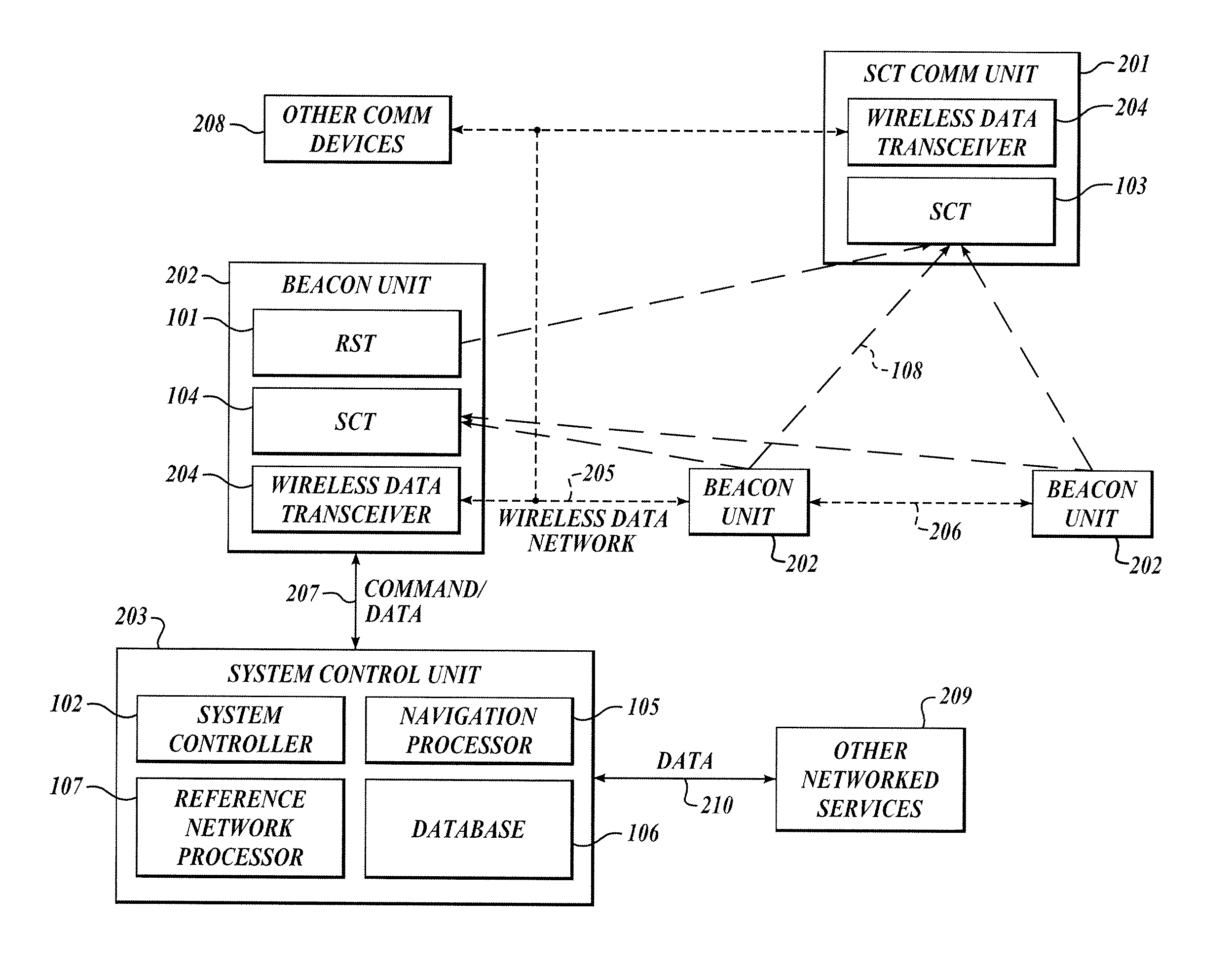
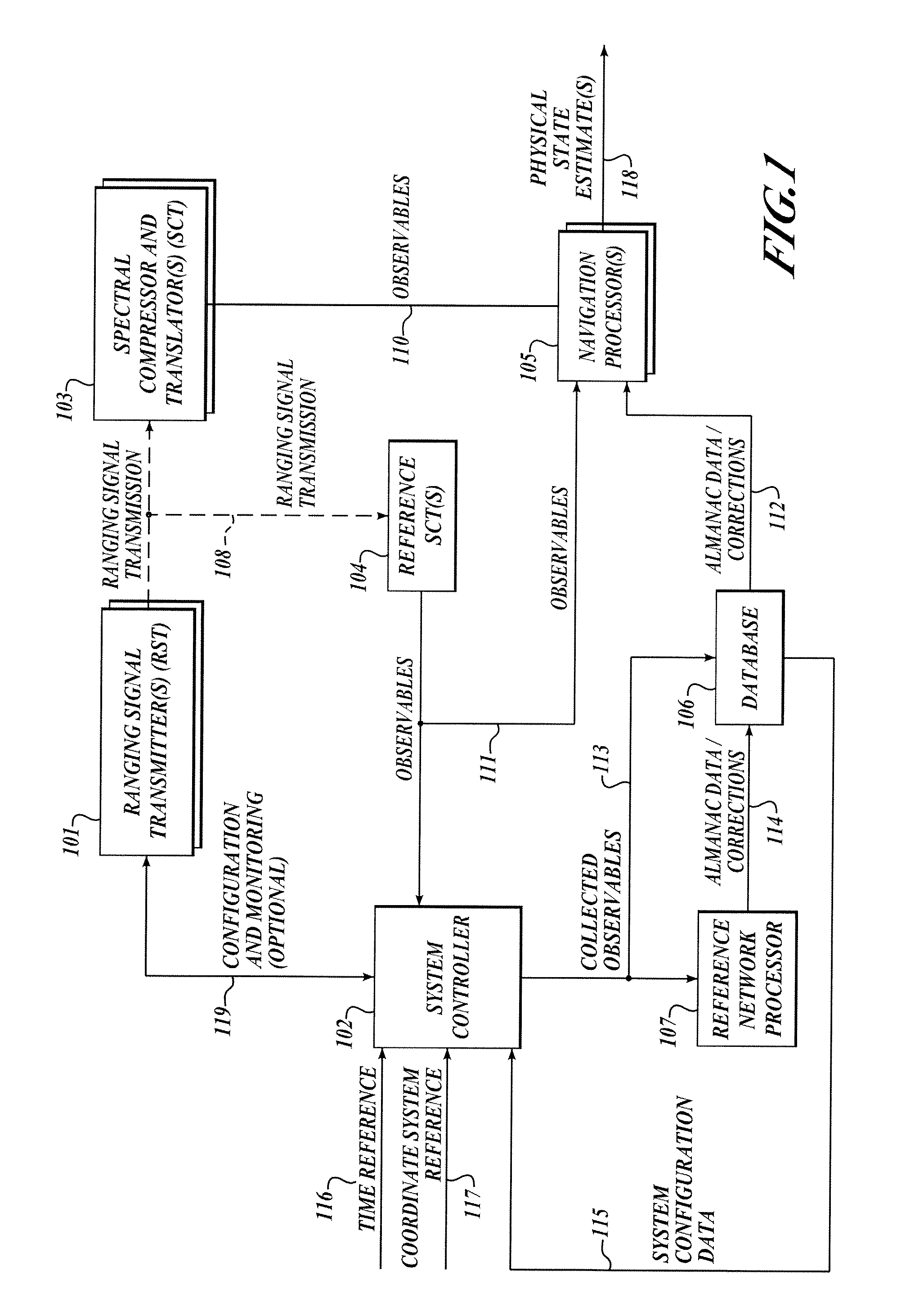
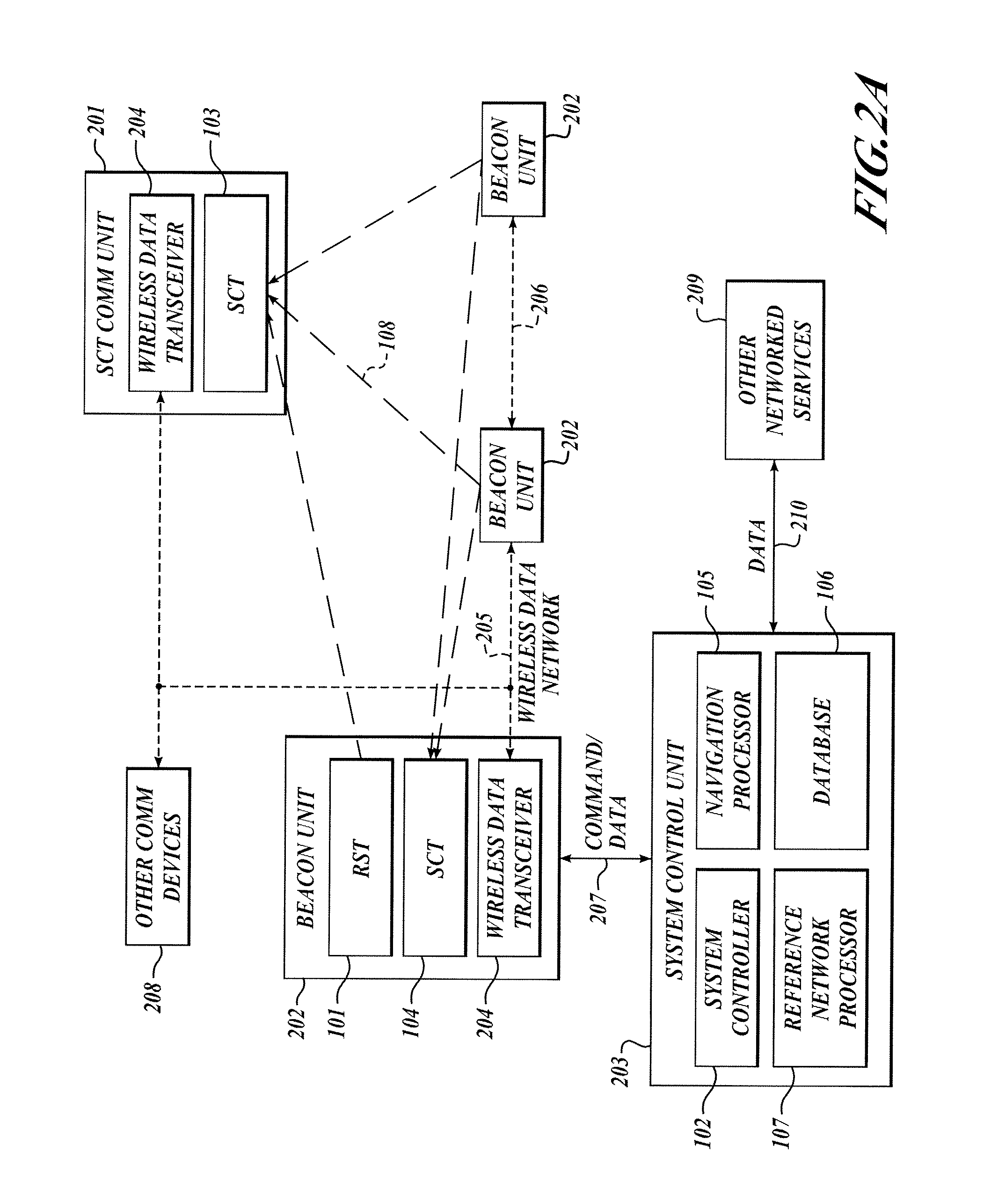
[0064] By way of overview, the present invention utilizes a beacon constellation environment, which although low in transmitter power (<1 microwatt), provides signal flux that is 40 to 60 dB more powerful than GNSS signals and thus is able to determine the physical state of a sensor in missions where GNSS is either absent or unreliable in the context of a configured environment or, in other words, an environment in which there is the ability to deploy a beacon constellation in a manner that affords the maximum of flexibility for the system operator. The constellation of beacons uses spread spectrum technique...


PUM


Abstract

The present invention relates to a system and method for providing location determination in a configured environment in which Global Navigation Satellite System Signals are not available. In this regard, local beacon systems generate spread spectrum CDMA signals that are received by spectral compression units that derive physically meaningful observations without a requirement for correlation of the intercepted energy by means of the known spreading codes. The invention can coexist with communication assets already in place, and the design allows for self calibration, which simplifies installation and usage. The invention has utility in applications in which GNSS signals are unavailable or limited, for example, in warehouse inventory management, in search and rescue operations and in asset tracking in indoor environments.

Description

PRIORITY CLAIM [0001] This application claims priority to U.S. Provisional Application No. 60 / 745,928, filed Apr. 28, 2006, which application is hereby incorporated by reference in its entirety as if fully set forth herein.FIELD OF THE INVENTION [0002] The invention generally relates to a system and method for positioning remote assets and, more particularly, to a system and method for operating in a local environment where a global navigation satellite system (GNSS) is not available. BACKGROUND OF THE INVENTION [0003] The global positioning system (GPS) has fundamentally changed the methods of navigation, location tracking, and time synchronization worldwide. With thirty-two satellites on orbit, the GPS provides continuous positioning service at almost anyplace signals can be received. With the advent of low-cost positioning sensors using GPS, accurate to a few meters, there has been a proliferation of the technology into core infrastructures including power systems, communications...

Claims


Application Information

Patent Timeline
Patent Type & Authority Applications(United States)
IPC IPC(8): G01S1/00G01S13/00H04B7/00H04B7/185G01S19/11G01S5/02G01S19/23
CPCG01S5/021G01S19/23G01S19/11G01S5/0289
Inventor MATHEWS, MICHAEL B.GOLD, KENN L.MACDORAN, PETER F.
Owner TELECOMM SYST INC
Why Eureka
Try Eureka