Method of mixed data assisted and non data assisted navigation signal acquisition, tracking and reacquisition

Active Publication Date: 2008-04-10
CSR TECH HLDG
View PDF9 Cites 18 Cited by
  • Summary
  • Abstract
  • Description
  • Claims
  • Application Information

AI Technical Summary

Benefits of technology

[0012]Accordingly, the present invention provides systems and methods for enabling a navigation signal receiver to perform both da

Problems solved by technology

Additional frequency variation may result from local oscillator instability.
However, under some conditions it

Method used


Image

  • Method of mixed data assisted and non data assisted navigation signal acquisition, tracking and reacquisition
  • Method of mixed data assisted and non data assisted navigation signal acquisition, tracking and reacquisition
  • Method of mixed data assisted and non data assisted navigation signal acquisition, tracking and reacquisition

Examples


Embodiment Construction

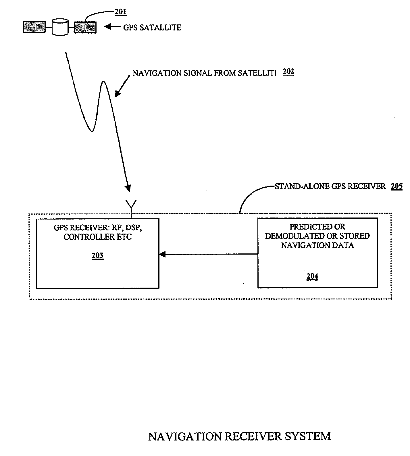
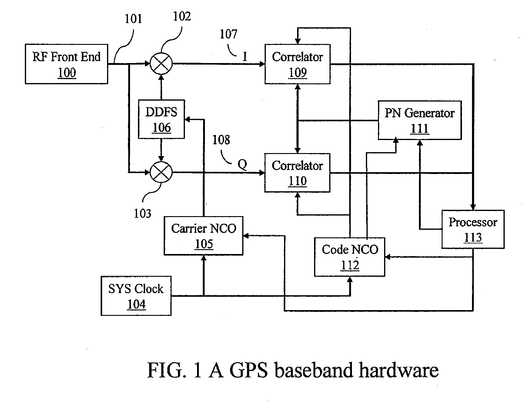
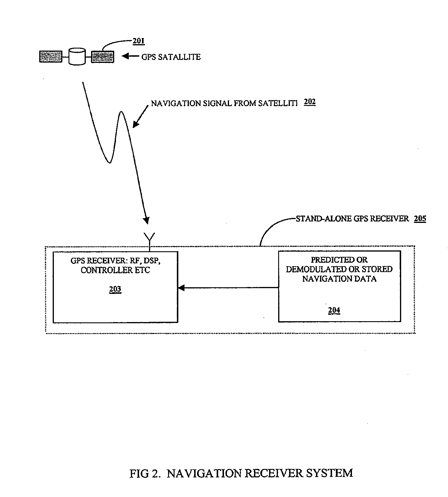
[0019]FIG. 1 illustrates a receiver according to a preferred embodiment of the invention. An intermediate frequency (IF) signal input 101 enters a baseband section of the receiver from an analog-to-digital converter (ADC) output of a conventional RF front-end 100. The IF input is multiplied in IF mixers 102 and 103 in-phase and in quadrature, respectively, with a local frequency signal generated by a direct digital frequency synthesizer (DDFS) 106. This mixing involves multiplying the ADC output 101 by the local DDFS frequency in-phase which generates the in-phase component I 107. In a parallel path the same signal 101 is multiplied by the DDFS frequency in quadrature (i.e., with a phase shift of 90 degrees) to produce quadrature component Q 108. The DDFS 106 is driven by a carrier numerically controlled oscillator (NCO) 105. In addition, carrier NCO 105 receives phase and frequency corrections from a processor 113. Because of this correction, the DDFS frequency and phase is almost ...


PUM


Abstract

The present invention provides systems and methods for enabling a navigation signal receiver to perform both data assisted and non-data assisted integration to provide better integration during signal acquisition, reacquisition and tracking. In data assisted integration mode, a receiver uses known or predicted data bits to remove the modulated data bits of a received signal prior to integration. In non data assisted integration mode, when the data bits are not known or predictable, the receiver uses an optimal estimation or maximum likelihood algorithm to determine the polarities of the modulated data bits of the received signal. This may be done by determining which of various possible bit pattern yields the maximum integrated power. When the modulated data bits are not known or predictable over a limited range, the receiver carries out data assisted integration over the known or predictable data bits and additional non data assisted integration.

Description

FIELD OF THE INVENTION[0001]The present invention relates generally to navigational signal receivers, and more particularly to systems and methods for weak navigation signal acquisition, tracking and reacquisition in data assisted mode and non-data assisted mode.BACKGROUND OF THE INVENTION[0002]With the development of radio and space technologies, several satellites based navigation systems have already been built and more will be in use in the near future. One example of such satellites based navigation systems is Global Positioning System (GPS), which is built and operated by the United States Department of Defense. The system uses twenty-four or more satellites orbiting the earth at an altitude of about 11,000 miles with a period of about twelve hours. These satellites are placed in six different orbits such that at any time a minimum of six satellites are visible at any location on the surface of the earth except in the polar region. Each satellite transmits a time and position ...

Claims


Application Information

Patent Timeline
IPC IPC(8): H03M7/38
CPCG01S19/254G01S19/246G01S19/27
Inventor WANG, CHI-SHINQIU, ZONGDEJIA, ZHIKE
Owner CSR TECH HLDG
Why Eureka
Try Eureka