System and method for locating, tracking, and/or monitoring the status of personnel and/or assets both indoors and outdoors

Active Publication Date: 2009-02-12
TRX SYST
View PDF101 Cites 658 Cited by
  • Summary
  • Abstract
  • Description
  • Claims
  • Application Information

AI Technical Summary

Benefits of technology

[0018]Information about specific buildings (or building data) may be an extremely valuable tool. It may, for example, help in situational awareness for emergency services, for navigation and mission planning, for viewing navigation and tracking data, and for improving the location estimates in the tracking data obtained from one or more tracking systems. Most buildings are characterized by common features such as long edges along the building's orientation, hallways, and possibly multiple floors (with stairwells, elevators, and escalators being the primary methods to change floors). In addition, buildings may be characterized, for example, by construction type, and layout type. The knowledge of building data may be used to improve the accuracy of both outdoor and, in particular, indoor tracking data by matching the tracking data to known building features. By combining information that may observed from aerial imagery, site surveying, user contribution, or various other sources, a c

Problems solved by technology

A variety of factors, however, can negatively impact the accuracy of such systems.
For example, although GPS has proved to be a useful navigation and tracking tool for outdoor tracking applications, a number of limitations exist when applying GPS to indoor navigation and tracking.
In indoor environments and in close proximity of most complex buildings, however, the line of sight of GPS satellites may be substantially obscured and GPS signals may be highly attenuated.
As a result, GPS signals are typically several orders of magnitude weaker in indoor environments than outdoors.
With such weakened signals, GPS receivers have difficulty receiving GPS signals and calculating accurate position information.
Inertial systems, however, may accumulate large errors over time due to factors such as drift in sensor offsets, sensitivity, and measurement limitations of the sensors, as well as limitations of the location determining methods (e.g., algorithms) implemented by such systems.
Additionally, the size and cost requirements to track personnel and/or smaller assets may necessitate the use of less expensive and robust inertial sensors, potentially increasing drift in the system.
While some man-made assets such as cars

Method used


Image

  • System and method for locating, tracking, and/or monitoring the status of personnel and/or assets both indoors and outdoors
  • System and method for locating, tracking, and/or monitoring the status of personnel and/or assets both indoors and outdoors
  • System and method for locating, tracking, and/or monitoring the status of personnel and/or assets both indoors and outdoors

Examples


Embodiment Construction

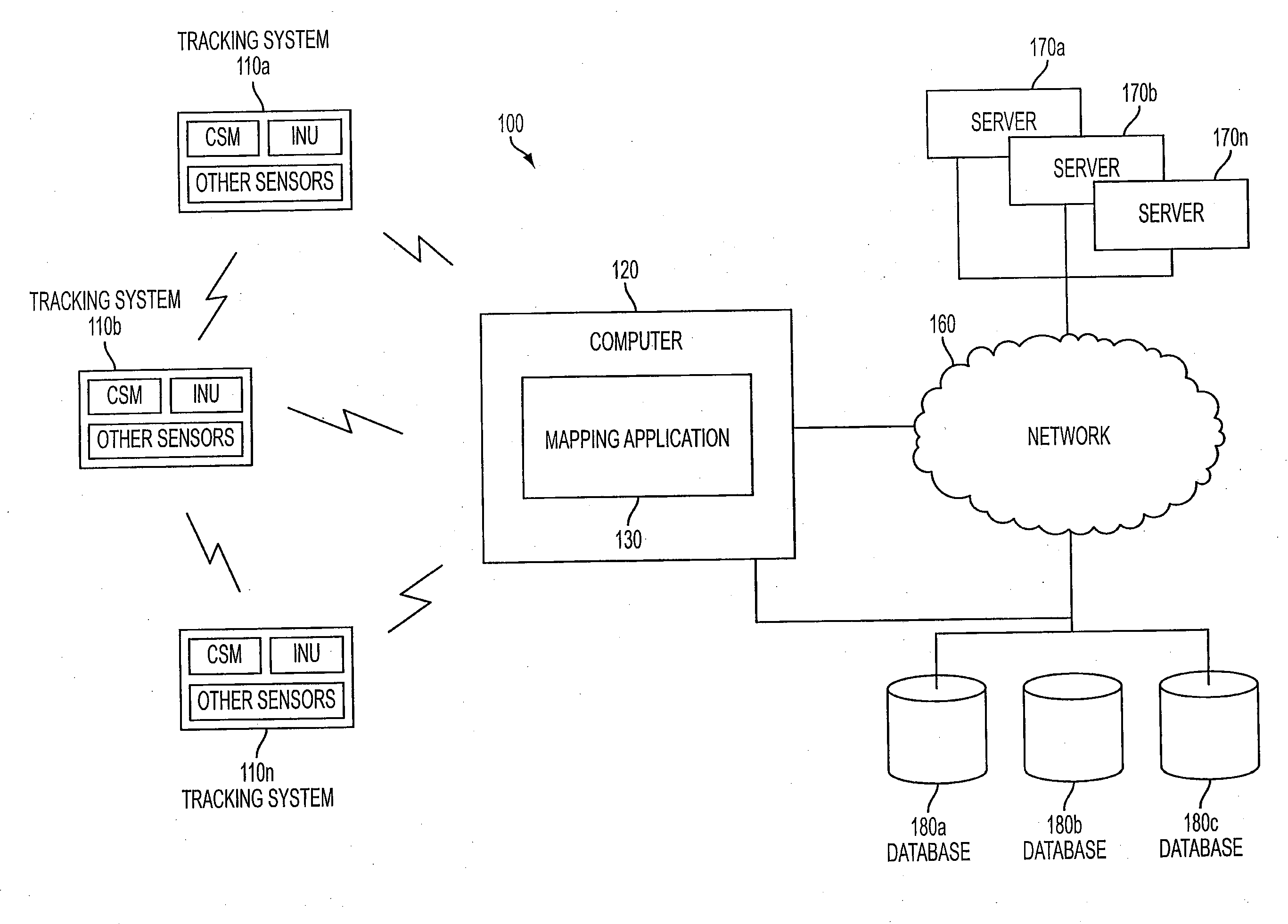
[0064]The invention described herein is directed to a system and method for locating, tracking, and / or monitoring the status of personnel and / or assets, both indoors and outdoors.

[0065]As a general overview, an exemplary system architecture will first be provided, followed by a discussion of the various types of input that may be provided to the mapping software application disclosed herein. In some instances, the mapping software application may be referred to interchangeably herein as “mapping software” or “mapping technology.” An overview of the features and functionality enabled by the mapping software application will then be described, followed by a discussion of various mapping techniques and tools. A description of various indoor tracking methods and outdoor tracking methods will also be provided.

[0066]I. Exemplary System Architecture

[0067]FIG. 1 depicts an exemplary system architecture 100, according to an aspect of the invention. In one implementation, one or more tracking...


PUM


Abstract

A system and method for locating, tracking, and/or monitoring the status of personnel and/or assets (collectively “trackees”), both indoors and outdoors, is provided. Tracking data obtained from any number of sources utilizing any number of tracking methods (e.g., inertial navigation and signal-based methods) may be provided as input to a mapping application. The mapping application may generate position estimates for trackees using a suite of mapping tools to make corrections to the tracking data. The mapping application may further use information from building data, when available, to enhance position estimates. Indoor tracking methods including, for example, sensor fusion methods, map matching methods, and map building methods may be implemented to take tracking data from one or more trackees and compute a more accurate tracking estimate for each trackee. Outdoor tracking methods may be implemented to enhance outdoor tracking data by combining tracking estimates such as inertial tracks with magnetic and/or compass data if and when available, and with GPS, if and when available.

Description

CROSS-REFERENCE TO RELATED APPLICATIONS[0001]This application claims priority to U.S. Provisional Patent Application Ser. No. 60 / 954,112, filed Aug. 6, 2007, and U.S. Provisional Patent Application Ser. No. 61 / 049,020, filed Apr. 30, 2008, each of which is hereby incorporated herein by reference in its entirety.STATEMENT REGARDING FEDERALLY SPONSORED RESEARCH OR DEVELOPMENT[0002]This invention was made with U.S. Government support under: (1) Contract No. IIP-0750498, awarded by the National Science Foundation; (2) Contract No. SBIR-HM1582-08-C-0007, awarded by the National Geospatial-Intelligence Agency; (3) Contract No. H98230-06-C-0450, awarded by the NSA; and (4) Contract No. N41756-04-C-4193, awarded by the Department of Homeland Security Technical Support Working Group. The U.S. Government has certain rights in this invention.FIELD OF THE INVENTION[0003]The invention relates generally to a system and method for locating, tracking, and / or monitoring the status of personnel and / o...

Claims


Application Information

Patent Timeline
IPC IPC(8): G01C21/00H04W4/021H04W4/029H04W4/33
CPCG01C17/38G01C21/165G01C21/206G01S5/0294G01S19/39G01S19/48G01C21/3626H04W64/00H04W4/043H04W4/028G01C21/16G01C21/3438G01S19/49H04W4/029H04W4/021G01S5/015G01C21/188G01C21/1652G01C21/1654H04W4/33
Inventor BANDYOPADHYAY, AMRITHAKIM, DANIELFUNK, BENJAMIN E.KOHN, ERIC ASHERTEOLIS, CAROLE A.BLANKENSHIP, GILMER
Owner TRX SYST
Why Eureka
Try Eureka