
Method for map matching with guaranteed integrity

Active Publication Date: 2009-09-17
GMV AEROSPACE & DEFENCE
View PDF8 Cites 23 Cited by
  • Summary
  • Abstract
  • Description
  • Claims
  • Application Information

AI Technical Summary

Benefits of technology

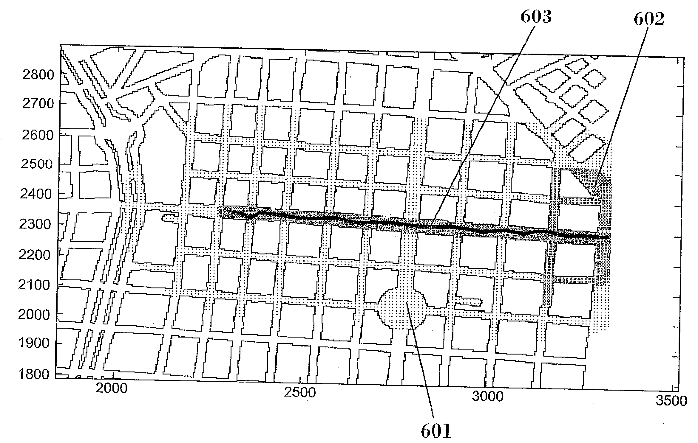
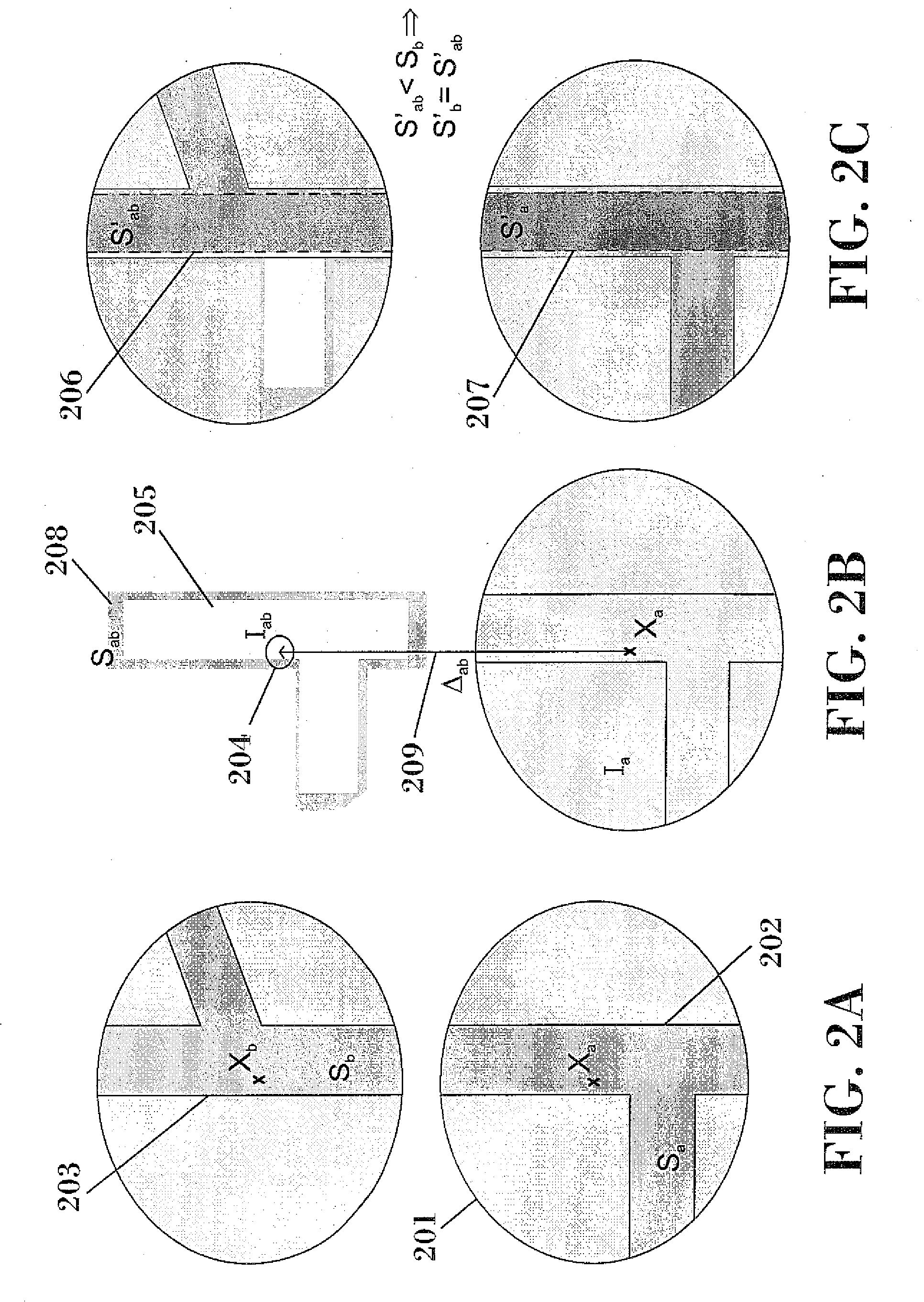
[0041]the passable area of instant ti is propagated to the immediately previous instant ti−1 by means of the position increase between both instants, taken in the opposite direction, and its associated integrity ellipse, eliminating the non-passable areas, and it is compared with the passable area previously calculated in ti−1, selecting the smallest of the two, or carrying out the intersection thereof, such as has been previously described;
[0050]The invention also provides the possibility of repeating steps 2) to 5) for each new position solution in each new instant, based on propagating the passable area from a previous instant which may or may not be the immediately previous instant, such that the new passable areas are determined along the trajectory of the user taking into account the previous ones for the purpose of progressively reducing the possible areas.
[0054]Direct estimation of the trajectory: in the case of GNSS positioning, in addition to processing the carrier phase measurements of the satellites, which allows calculating the position increase between two instants, it is also possible to optionally add the processing of Doppler measurements, from which the instantaneous velocity is obtained, incorporating a dynamic user model taking into account the restrictions in the users movement in terms of velocity and linear acceleration and possible maximum angles. Only the areas through which a passable path runs at all times are thus selected, it being possible to obtain a continuous, precise and integral trajectory on the map.
[0056]The method can use different criteria for selecting the instant from which the passable area (ta) is propagated, such as storing the information of an instant with maximum observability and integrity ellipse with minimum size, or minimum passable integral area for example, for the purpose of reducing the passable areas of future instants, or simply propagating the area of the previous instant to the current one. It must be taken into account that the uncertainty in the increase of the phase measurement, and therefore of the position increase, increases over time, which will increase the area in the propagation.

Problems solved by technology

However, the reality is quite different since there are phenomena causing errors in the GNSS position—errors relating to satellites, atmospheric delays, multipath or signal reflection, particularly important in urban environments—, which can cause errors of up to hundreds of meters, as well as errors in the process of creating digital maps, mainly due to the scale factor, transforming coordinates, translating from a curved surface to a planar surface (generalization), position reference (datum) and the digitalization process.
However the precision of these methods is not assured, nor do they provide the user with a confidence value, or integrity, of the adopted solution, but rather they are focused on adjusting the position to a segment in the best possible manner in most cases.
for example not being based on the integrity of the position which the navigation system provides, but rather it uses the covariance matrix only for selecting the possible roads within an area having great probability, which is not enough to guarantee the integrity of the position;
or for example proposing to use the direction of the movement for ruling out segments, risking ruling out the correct road in the case of turning, lane change, or error in calculating the direction of the movement, whereby upon using non-integral methods for selecting the road, the initial integrity, if there was any, would lose validity.
Nevertheless the concept of integrity used does not correspond to the concept rigorously used in this patent, which is based on the concepts introduced by civil aviation.
However, in addition to the fact that this indicator does not provide any integrity guarantee in and of itself, it will give a false alarm in the event that the vehicle is turning or changing lanes, and the direction does not coincide with that of the segment, or it will not detect a failure if the wrong road coinciding with the direction of the movement is selected for any reason.Integrity based on the ability to precisely determine the position of the vehicle: An uncertainty indicator (R3dms) based on the covariance of the GPS position plus the typical road width is subtracted from the distance between the GPS position and the position given by the MM algorithm.
This indicator does not provide a quantifiable integrity measurement, nor does it assure integrity in the event that the result is negative or close to zero.
Based on the foregoing, it is concluded that the integrity provided by this algorithm cannot be considered reliable in all fields since it is not quantifiable nor is it based on theoretical fundamentals, therefore it can not be extrapolated to other situations beyond the experiments conducted.
Therefore it does not provide the confidence necessary for critical safety applications or applications having legal or contractual implications.
In addition, the performance level obtained (98.2% in the best of cases) does not seem to be sufficient for critical applications and is well under the confidence index of the method proposed herein.
Nevertheless, said method does not provide any integrity indicator.
Although it improves the reliability of the algorithm, 31.8% of failures still go undetected according to the results of the experiment conducted, and furthermore the method does not define or calculate a confidence value for the obtained solutions, but rather it is reduced to improving the reliability of the current MM techniques.
Despite said reliability checking, this method does not assure the confidence of the selected solution.
As with the aforementioned background documents, it does not assure integrity.
It relates to improving the determination of the road in time real and does not assure integrity.

Method used


Image

  • Method for map matching with guaranteed integrity
  • Method for map matching with guaranteed integrity
  • Method for map matching with guaranteed integrity

Examples


Embodiment Construction

[0023]The invention relates to a method for determining a road or a set of passable roads or areas traveled by a user with a minimum associated probability or integrity according to claim 1, and the use of said method in a recurrent manner over time for the purpose of determining the trajectory followed by the user with integrity according to claim 2. Preferred embodiments of the method are described in the dependent claims.

[0024]According to a first aspect of the invention, a method for determining a road or a set of passable roads or areas traveled by a user with a minimum associated probability or integrity is provided, which comprises:

[0025]receiving from a positioning system information relating to a first and a second position solutions PVT of said user in a first instant of time ta and in a second instant tb after the first instant ta, respectively, as well as respective position integrity ellipses, Ia and Ib, each with a minimum associated probability Pa and Pb that the user...


PUM


Abstract

The invention relates to a method for determining a set of passable roads or areas traveled by a user with a minimum associated probability or integrity which comprises:receiving from a GNSS system respective position solutions PVT of said user in respective instants of time ta and tb, respectively, and respective position integrity ellipses, Ia and Ib (201), with respective minimum associated probabilities, Pa and Pb, that the user is located in each of them in ta and in tb, respectively, and a position increase Δab between ta and tb with its position increase integrity ellipse Iab (204) and its associated probability Pab;obtaining from a GIS system respective passable areas corresponding to said PVT solutions,determining a first passable integral area Sa=Ia∩TGIS (202) and a second passable integral area Sb=Ib∩TGIS (203) as an intersection for each instant of time of said position integrity ellipses with said passable areas;propagating said first passable integral area to the subsequent instant tb by means of the position increase, considering the uncertainty associated to said increase determined by the integrity ellipse of the velocity Iab and its associated probability Pab (204), obtaining a propagated integral area Sab (205);eliminating from said propagated integral area Sab the non-passable areas, obtaining a propagated passable integral area S′ab (206);determining a final passable integral area S′b formed by a road or a set of passable roads in the second instant tb as an intersection of said second passable integral area and of said propagated passable area or as the smallest of said areas; anddetermining in each case the minimum probability P′b that the user is located in said final passable integral area S′b.

Description

FIELD OF THE INVENTION[0001]The present invention belongs to the field of positioning applications, particularly those requiring or benefiting from the use of geographic information and needing a high service or integrity guarantee, such as positioning by means of a satellite navigation system for users and ground vehicles circulating through a network of streets and highways for example.[0002]The invention can be used both for critical safety applications and for those entailing legal or contractual responsibilities.BACKGROUND OF THE INVENTION[0003]The use of Global Navigation Satellite Systems (GNSS), such as GPS, for positioning vehicles is currently very widespread. A user is able to determine his or her position and a temporal reference by means of receiving and processing the signal of several satellites. This information is determined by knowing the position of the satellites and the time that the signal has taken to reach the user. It is further necessary to estimate the del...

Claims


Application Information

Patent Timeline
IPC IPC(8): G01C21/26
CPCG01C21/30G01S19/20
Inventor FERNANDEZ-HERNANDEZ, IGNACIOCARO RAMON, JOSETOLEDO LOPEZ, MANUELMARTINEZ OLAGUE, MIGUEL ANGELAZAOLA SAENZ, MIGUEL
Owner GMV AEROSPACE & DEFENCE
Features
  • Generate Ideas
  • Intellectual Property
  • Life Sciences
  • Materials
  • Tech Scout
  • Unparalleled Data Quality
  • Higher Quality Content
  • 60% Fewer Hallucinations
Learn More