Managing landbases and machine operations performed thereon

a technology of machine operations and land bases, applied in the field of management of land bases and machine operations performed thereon, can solve the problems of increasing the cost of operations, so as to achieve the effect of reducing the cost of operations

Active Publication Date: 2009-11-12
GENESIS INDS
View PDF27 Cites 39 Cited by
  • Summary
  • Abstract
  • Description
  • Claims
  • Application Information

AI Technical Summary

Benefits of technology

[0012]It is a further object, feature, or advantage of the present invention to provide real-time visual referencing and position of equipment and operators in relation to one another.
[0013]It is a still further object, feature, or advantage of the present invention to provide a real-time display for equipment operators of the relative location of all electronically tagged ground personnel working in close proximity to forest management equipment.
[0014]Yet another object, feature, or advantage of the present invention is to provide for real-time documentation and mapping of actual forest management events and activities.
[0015]A still further object, feature, or advantage of the present invention is to provide equipment operators with a GIS application.
[0016]Another object, feature, or advantage of the present invention is to provide yield monitoring based on extrapolation or direct sensing to develop forest productivity models which may be used in developing maps for variable rate applications with regards to fertilization or herbicide applications.
[0017]Yet another object, feature, or advantage of the present invention is to provide a real-time data log, which may be used for determining the “actual” operational efficiency of equipment with regards to the performance of the exact task for which said equipment was designed vs. actual total time of operation over any pre or post determined period of time.

Problems solved by technology

These mechanisms for correcting the accuracy of land base data are often slow, costly and can be delayed by adverse weather conditions such as cloud cover in the case of remote sensing.
A major concern associated with delays in correcting management data, is subsequent operations that rely on this data and the potential economic and environmental impact of inaccurate information.
With operations such as fertilization, competitive vegetation management, mechanical site preparation and planting, significant costs are incurred by the land owners or managing entities with each operation.
For every acre of land that is improperly managed or accounted for, there is an associated cost.
Sensitive areas such as streamside management zones (SMZ's) or protected wildlife areas may possess no potential economic return despite receiving additional inputs such as fertilizer or herbicide.
Additionally, there may be negative environmental impacts such as surface water contamination with fertilizer or non-target injury of non-crop trees such as hardwoods in the SMZ.
Aside from the negative impacts associated with poor data in forest management activities, there exists the issue of improper asset valuation in timber stands derived from the classification of land as either productive “crop” areas or environmental management areas such as SMZ's.
Additionally, certain areas within productive crop areas may have been damaged due to insect infestations, fires, or flooding, rendering them non-productive until the next crop rotation.
Furthermore, harvesting practices associated with timber production have suffered greatly in terms of production efficiency as a result of suppressed operator situational awareness in wooded settings.
Due to the reduced sense of awareness an equipment operator may experience, with regards to his or her specific location within a defined parcel of property, a diminished level of equipment production efficiency as a result of the reoccurring act of identifying and verifying ones exact position or the direction in which to proceed with a prescribed activity.
In other words, an operator may not be able to see the proverbial forest for the trees.
This level of confusion or inefficiency often results in, but is not limited to: the incomplete harvesting or maintenance of specified areas, inaccurate delineation of areas that are harvested, suboptimal layout and design of harvest or maintenance activities, incomplete harvest cycles with harvested timber not being retrieved for delivery to mills, inaccurate estimates of projected completion times, or improper allocation of logistics resources such as trucking.
These solutions each contain a significant level of ineffectiveness due to errors in either information interpretation or the inability to transfer properly the actual physical location of an operator or equipment to the reference point on the associated support documents.
In terms of dispatch transportation the “estimation” often resulted in the inappropriate allocation of trucks for transporting the available product to processing centers which in turn results in increased transportation costs or decreased production at the harvest site with either too many or too few trucks being dispatched.

Method used


Image

  • Managing landbases and machine operations performed thereon
  • Managing landbases and machine operations performed thereon
  • Managing landbases and machine operations performed thereon

Examples


Embodiment Construction

I. Overview

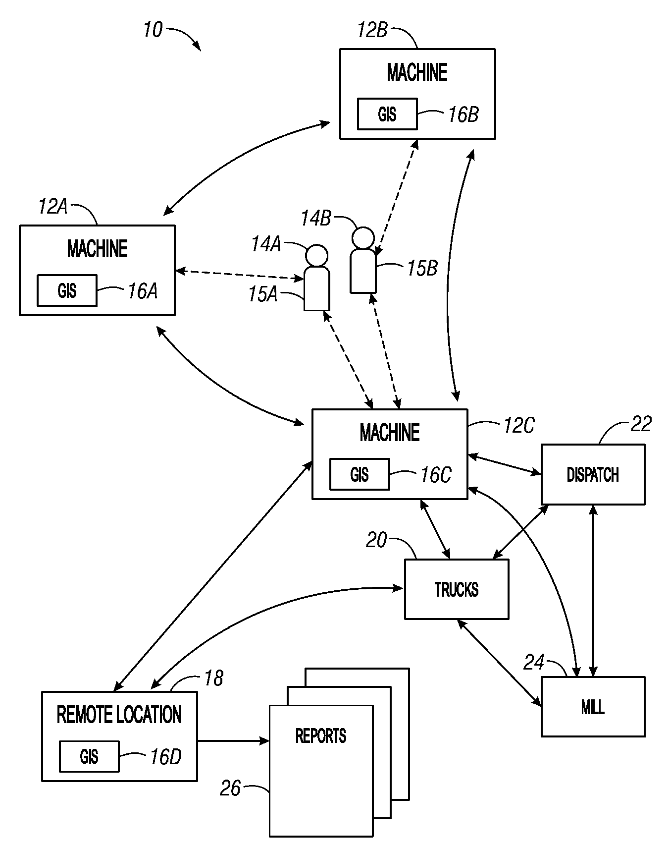
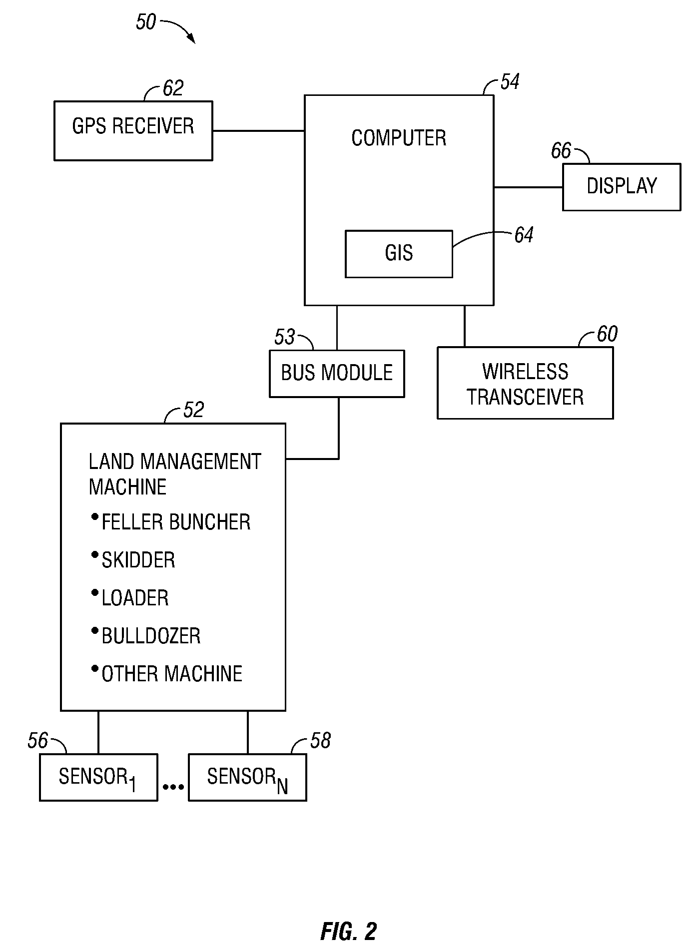
[0043]The present invention applies a new approach to the activities associated with land management. The present invention relates to recording, documenting, processing, correcting, managing, and sharing all information regarding any management activities that deal with the direct interaction of equipment and people with land, natural resources, or recreational areas. The present invention may be used as a part of a complete system to collectively interact with and aid in managing all aspects and operations simultaneously. Alternatively, different aspects of the invention may be used separately. The present invention may provide advantages relating to enhancing individual equipment productivity, increasing operator safety, increasing operational efficiency, increasing security, or increasing overall quality of operations regarding land stewardship.

[0044]One aspect of the present invention allows for the data collection to be performed at the location and time of need, su...


PUM


Abstract

A method for management of a land base includes interfacing a machine or equipment to a computer running a geographical information system (GIS) application such that the computer is configured to monitor the operations performed by the equipment or machine on the land base and store the operations as map points, lines, or polygons on at least one data layer within the GIS application. The method further includes displaying the GIS application to the operator at the point and time of performing the operations.

Description

FIELD OF THE INVENTION[0001]The present invention relates to a method for management of land bases and machine operations performed thereon.BACKGROUND OF THE INVENTION[0002]The background of the invention is generally provided in the context of forest management. However, it is to be understood that forest management is merely one type of land management. Regarding forest management, historical land management practices have relied on data that contains an inherent amount of inaccuracy with regards to land boundaries, buffered areas, road utilization zones, and general forest area composition. The mechanisms for managing this inaccuracy and means for correcting it vary, and have included but not been limited to: United States Geological Survey maps, land ownership maps, traditional methods of surveying, collection of hand mapped GPS data, creation of boundary shape files utilizing remote sensing photographs and / or images. Remote sensing data utilized has included, but not been limit...

Claims


Application Information

Patent Timeline
Patent Type & Authority Applications(United States)
IPC IPC(8): G06F17/00
CPCG06Q10/06G06F3/0488G06F3/04842G06Q50/02G06Q50/163A01G23/00A01G23/006A01G23/081B60K35/00B60Q9/00G06F3/04847G06F3/04886
Inventor GEIS, CHAD W.GEIS, DALLAS L.MADDEN, RYAN
Owner GENESIS INDS
Why Eureka
Try Eureka