Building segmentation for densely built urban regions using aerial lidar data

Active Publication Date: 2009-12-17
SRI INTERNATIONAL
View PDF4 Cites 107 Cited by
  • Summary
  • Abstract
  • Description
  • Claims
  • Application Information

AI Technical Summary

Benefits of technology

[0008]Segmenting the non-ground points into buildings and clutter can further comprise estimating local surfels of the non-ground points at an adaptive scale; grouping non-ground surfels into coarse regions using a bottom up region growing technique; estimating planes for each course region; refining the location of the planes by fitting points to the planes by employing an expectation maximization technique; and segmenting building regions from the planes so as to enforce neighborhood constraints between planes and ensure sharp boundaries between regions by employing a loopy belief propagation (BP) framework. Voxels that are not grouped into any of the planes are removed as clutter. Estimating local surfels can further comprise computing the local covariance at multiple scales at each voxel which contains 3D data. Grouping non-ground surfels into coarse regions can further comprises the steps of determining a histogram of local normal orientation and computing a measurement of local planarity by integrating normal direction cues over a large area; and starting region growing from voxels which have a higher degree of local planarity, wherein a voxel is joined into a proposed region if local planar regions are coherent. Estimating planes for each course region can further comprise en

Problems solved by technology

Ground-based data provides high details on facades of buildings, but lacks information on tops of buildings.
Aerial data can yield very accurate building footprints and can facilitate the fusion of multiple images through ortho-rectification to cover large geographical areas, but aerial data generally lacks information on the sides of buildings necessary for producing a 3D model.
Most of the research on building modeling has employed 2D imagery, which is very inexpensive to acquire, but poses inherent difficulties for automatic 3D modeling due to known limitations of stereo algorithms for recovering 3D structure from multiple views, especially in untextured areas and at depth discontinuities.
B

Method used


Image

  • Building segmentation for densely built urban regions using aerial lidar data
  • Building segmentation for densely built urban regions using aerial lidar data
  • Building segmentation for densely built urban regions using aerial lidar data

Examples


Embodiment Construction

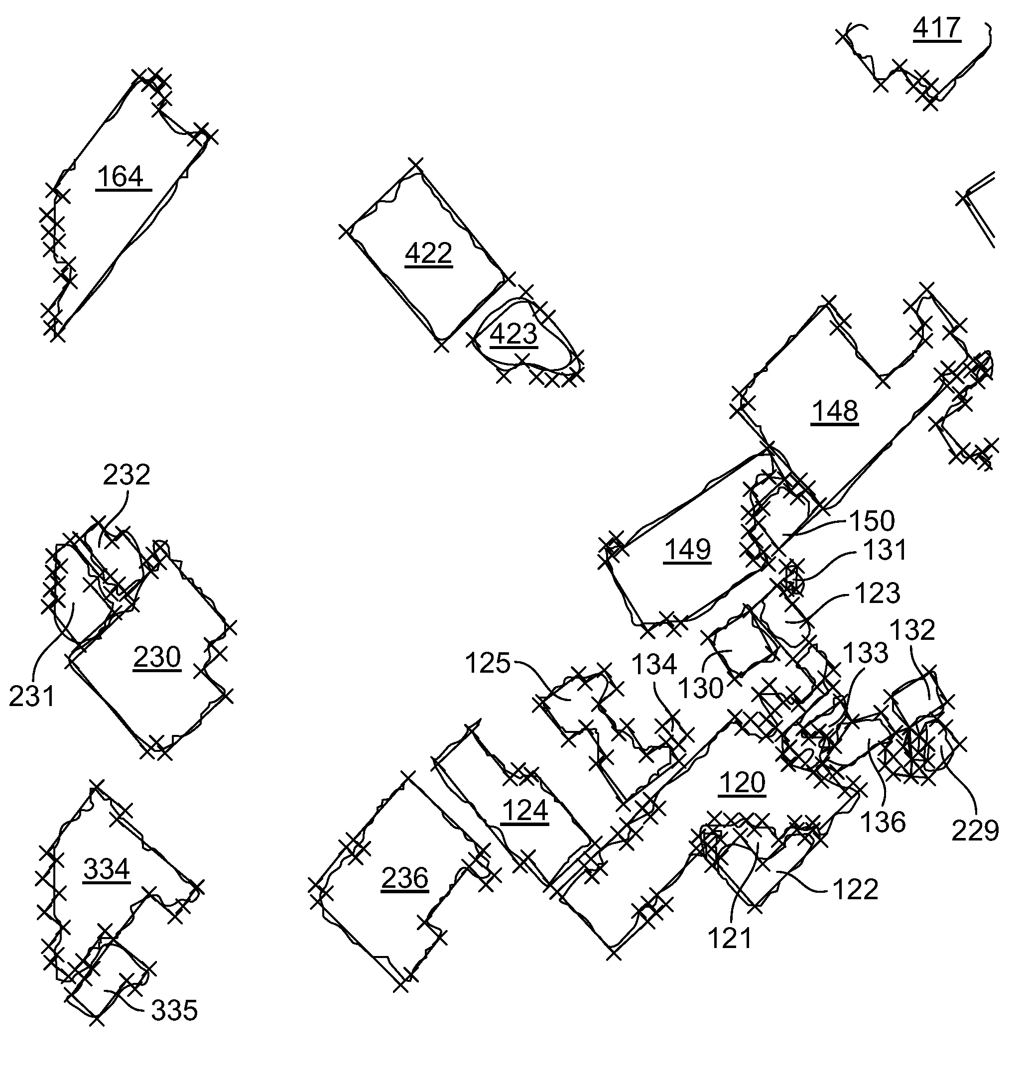
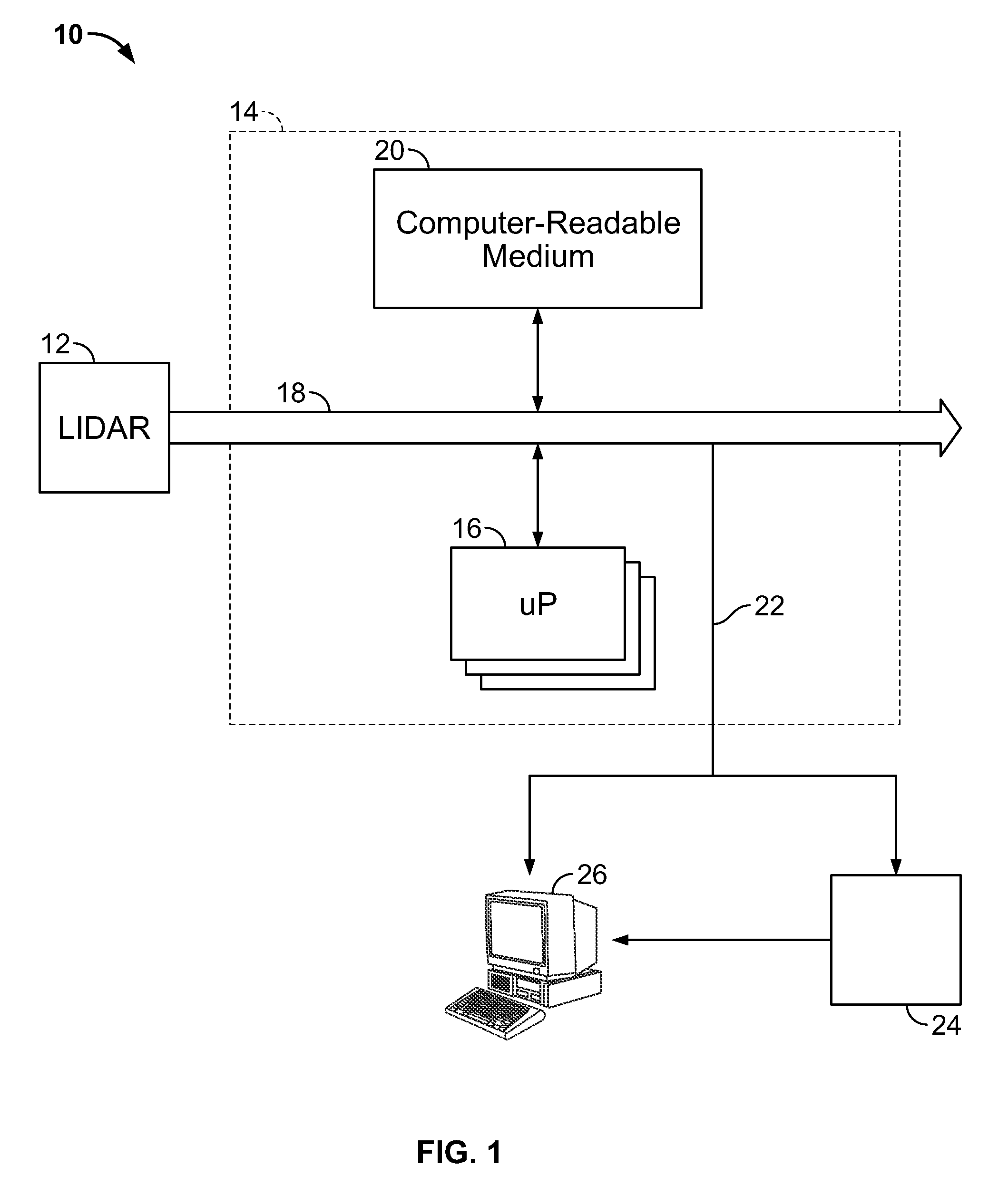
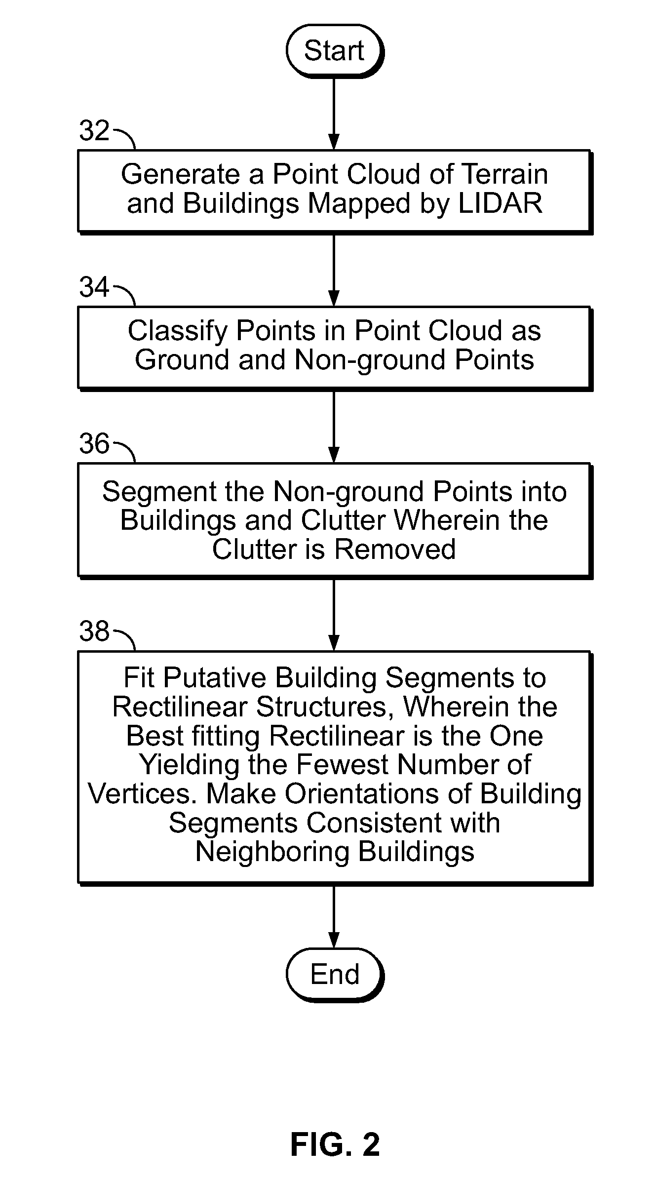
[0021]Referring now to FIG. 1, a system for automatically extracting 3D models of dense urban regions using aerial LIDAR data is shown, generally indicated at 10. By way of a non-limiting example, the system 10 receives aerial LIDAR data from a LIDAR system 12. The system 10 can include a computing platform 14. The computing platform 14 may include a personal computer or work-station (e.g., a Pentium-M 1.8 GHz PC-104 or higher) comprising one or more single or multi-core processors 16 which includes a bus system 18 which connects the one or more processors 16 with the computer-readable medium 20. The computer readable medium 20 can also be used for storing the instructions of the system 10 to be executed by the one or more processors 16, including an operating system, such as the Windows or the Linux operating system. The one or more processors 16 generate one or more 3D terrain maps from the computer-readable medium 20, thereby functioning as a 3D map generator. The computer readab...


PUM


Abstract

A method for extracting a 3D terrain model for identifying at least buildings and terrain from LIDAR data is disclosed, comprising the steps of generating a point cloud representing terrain and buildings mapped by LIDAR; classifying points in the point cloud, the point cloud having ground and non-ground points, the non-ground points representing buildings and clutter; segmenting the non-ground points into buildings and clutter; and calculating a fit between at least one building segment and at least one rectilinear structure, wherein the fit yields the rectilinear structure with the fewest number of vertices. The step of calculating further comprises the steps of (a) calculating a fit of a rectilinear structure to the at least one building segment, wherein each of the vertices has an angle that is a multiple of 90 degrees; (b) counting the number of vertices; (c) rotating the at least one building segment about an axis by a predetermined increment; and (d) repeating steps (a)-(c) until a rectilinear structure with the least number of vertices is found.

Description

FIELD OF THE INVENTION[0001]The present invention relates generally to computer vision, and more particularly, to a method for automatically extracting 3D models of dense urban regions using aerial LIDAR data.BACKGROUND OF THE INVENTION[0002]Building modeling has numerous applications in a wide variety of tasks such as urban planning, cartography, 3D visualization for virtual city tours and autonomous robot navigation. In many practical situations, it is desired to obtain 3D models for areas of hundreds and thousands of square kilometers within days and with minimal manual interaction. Traditionally, building modeling has employed data collected either from the ground or from the air. Ground-based data provides high details on facades of buildings, but lacks information on tops of buildings. Aerial data can yield very accurate building footprints and can facilitate the fusion of multiple images through ortho-rectification to cover large geographical areas, but aerial data generally ...

Claims


Application Information

Patent Timeline
IPC IPC(8): G06K9/46
CPCG06T7/0081G06T2207/30184G06T2207/10032G06T7/11
Inventor MATEI, BOGDAN CALIN MIHAISAMARASEKERA, SUPUNKIM, JANET YONGAKARNEY, CHARLES FIELDING FINCHSAWHNEY, HARPREET SINGHKUMAR, RAKESH
Owner SRI INTERNATIONAL
Why Eureka
Try Eureka