Method and apparatus for software GPS receiver

a software gps receiver and receiver technology, applied in the field of receiving methods and apparatuses, can solve the problems of significant signal distortion, large doppler shift between the relative velocity of the gps receiver and the satellite, and transmission through the ionospher

Inactive Publication Date: 2010-08-05
ANALOG DEVICES INC
View PDF8 Cites 24 Cited by
  • Summary
  • Abstract
  • Description
  • Claims
  • Application Information

AI Technical Summary

Benefits of technology

[0024]A new receiver architecture favoring software or low-power hardware implementation for processing spread spectrum signals is disclosed. In common to conventional approach, the receiver has an RF front end to receive and down convert a broadcast signal to an IF carrier, and an A / D converter to digitized the IF signal. The processing afterwards adopts a new procedure and architecture that enable software or ultra-low power hardware implementations. Instead of combined IF and Doppler frequencies removal, the IF carrier is removed solely and a baseband low pass filter is applied. The resulted signal is provided to a number of channels, each, for example, corresponding to a unique (satellite) transmitter. On each channel, the signal is immediately down-sampled to a predetermined fixed rate such as the chip rate of the spreading code. At the same time, the clock error and Doppler time shift is compensated. Then the residual Doppler frequency shift, as estimated for the channel, is removed from the signal at the low data rate. A locally generated copy of the spreading code used by the transmitter is applied to the resulted signal at the predetermined sample rate and with fixed number of samples per code length. The de-spread signal is used to perform estimation of residual mismatching in time and frequency and provide information for the next round of tracking operation. Pseudo-range and delta pseudo-range estimates from each channel are also computed and are used to estimate, for example, the receiver's position.

Problems solved by technology

By the time the broadcast modulated signal reaches a GPS receiver, it may be significantly distorted.
The relative velocity of the GPS receiver and a satellite may introduce large Doppler shifts.
Transmission through the ionosphere may also introduce significant signal distortions.
However, development costs associated with ASICs are considerably greater than for software and ASIC solutions lack the flexibility to adjust themselves to meet changing performance requirements.

Method used


Image

  • Method and apparatus for software GPS receiver
  • Method and apparatus for software GPS receiver
  • Method and apparatus for software GPS receiver

Examples


Embodiment Construction

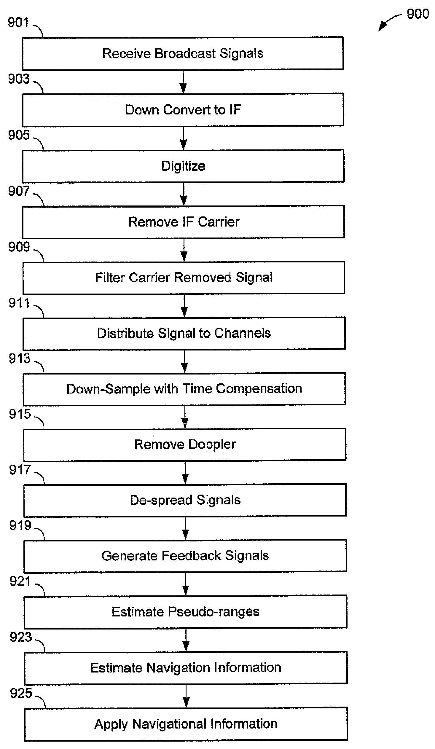
[0048]Central processing units (CPUs) and their “cousins,” digital signal processors (DSPs), have an incredible versatility to implement algorithms and methods provided through software commands. As compared to a dedicated hardware implementation, of a signal processing function, software to implement equivalent functionality often may be developed more quickly and with considerably less expense. As well, software is revised at much lower expense and at a much lower capital investment, and usually more quickly. However, dedicated hardware often is used when a CPU or DSP simply cannot be operated fast enough to perform a desired function in a set time.

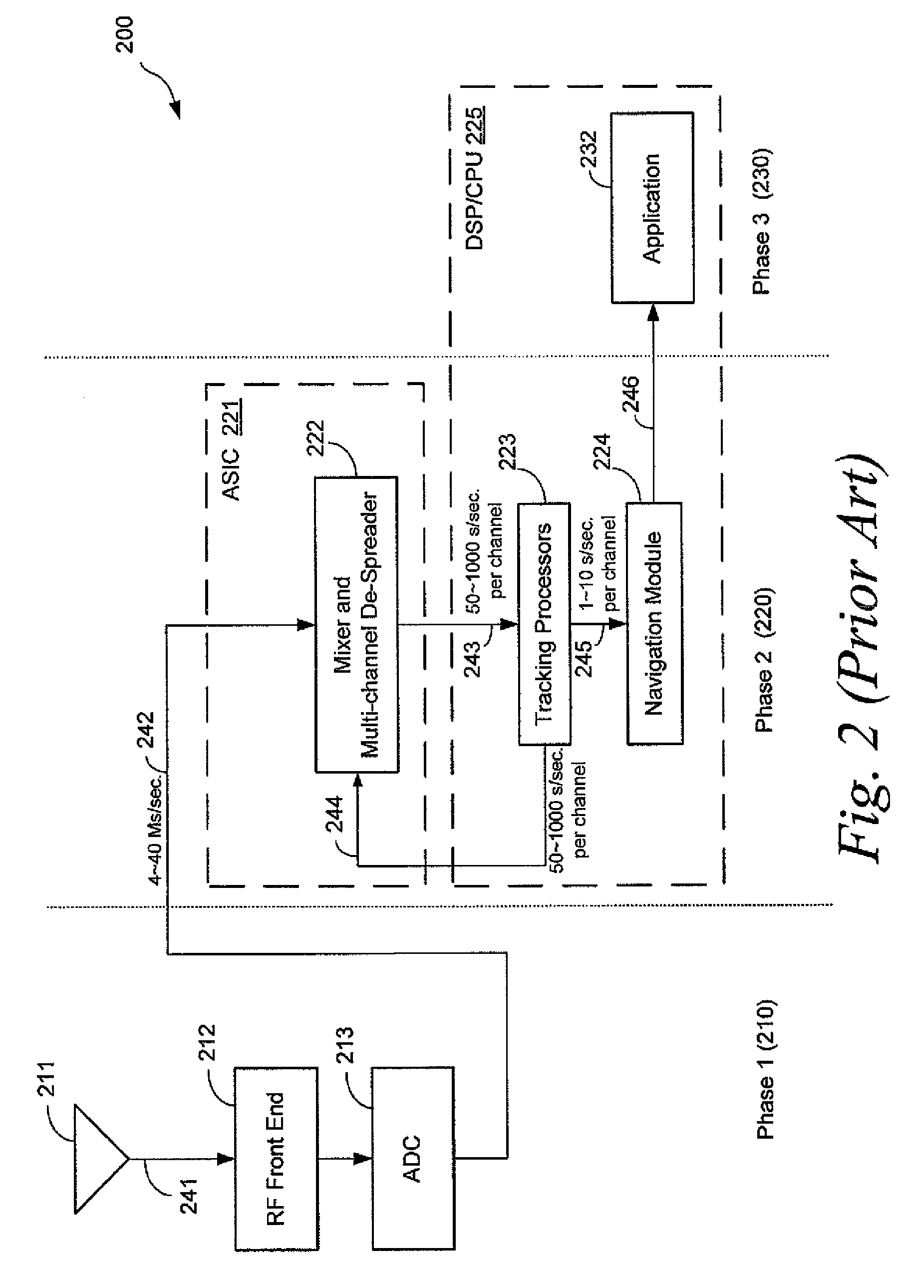
[0049]GPS receivers have conventionally been designed to use both dedicated hardware (e.g., one or more application-specific integrated circuits, or ASICs) and a DSP for executing software, ASICs generally being used to implement algorithms that required very high data rates.

[0050]A receiver architecture is presented that eliminates the...


PUM


Abstract

A receiver architecture for processing spread spectrum signals. The receiver has an RF front end to receive and down convert a broadcast signal to an intermediate frequency carrier. The IF signal is digitized and provided to a processor (which may be a software-driven DSP, an ASIC or other embodiment) for processing. A given IF carrier is removed and the signal is low pass filtered. The signal is provided to a number of channels, each, for example, correspond to a unique transmitter. On each channel the sample rate is reduced to a predetermined fixed rate with timing mismatch compensated. The Doppler frequency shift, as estimated for the channel, is removed succeedingly. A locally generated copy of the spreading code used by the transmitter is applied to the carrier and Doppler removed signal at the predetermined fixed sample rate. The de-spread signal is used to provide estimates of the Doppler shift and for subsequent sample selection. Pseudo-range and delta pseudo-range estimates from each channel are used to estimate, for example, the receiver's position.

Description

BACKGROUND[0001]1. Field of the Invention[0002]The invention relates generally to methods and apparatus for receiving, especially tracking of, direct-sequence spread spectrum (DSSS) signals such as GPS signals.[0003]2. Description of Related Art[0004]The Global Positioning System (GPS) is a global navigation satellite system (GNSS) that provides geo-spatial positioning with global coverage. GPS generally employs at least 24 satellites in six 20,200 km circular orbits. Four satellites operate in each plane. The orbits are arranged so that at least six satellites are always within line of sight from almost everywhere on Earth's surface.[0005]GPS receivers use triangulation of the GPS satellites navigational signals to determine their location. The satellites provide at least two different signals that enable location determination with differing accuracies. Coarse-acquisition (C / A) code is intended for civilian use, and is deliberately degraded from the maximum accuracy known to be po...

Claims


Application Information

Patent Timeline
Patent Type & Authority Applications(United States)
IPC IPC(8): G01S1/00
CPCG01S19/24G01S19/37H04B1/707
Inventor AN, WEISTEIN, YOSEF
Owner ANALOG DEVICES INC
Why Eureka
Try Eureka