Method and device for estimation of the integrity risk in a satellite navigation system

a satellite navigation system and integrity risk technology, applied in measurement devices, satellite radio beaconing, instruments, etc., can solve the problems of affecting the accuracy, affecting the computing time required to estimate the integrity risk, and excessively small values found

Active Publication Date: 2010-11-18
AIRBUS DEFENCE & SPACE
View PDF1 Cites 7 Cited by
  • Summary
  • Abstract
  • Description
  • Claims
  • Application Information

AI Technical Summary

Benefits of technology

[0015]As stated above, a user system can itself estimate the integrity risk, so as to be able to decide whether received navigation signals should be used to determine the position or whether they should be disr

Problems solved by technology

Furthermore, the selection of the number of intervals can alter the computing time required to estimate the integrity risk and the accuracy.
Thus, an increase in the number of

Method used


Image

  • Method and device for estimation of the integrity risk in a satellite navigation system
  • Method and device for estimation of the integrity risk in a satellite navigation system
  • Method and device for estimation of the integrity risk in a satellite navigation system

Examples


Embodiment Construction

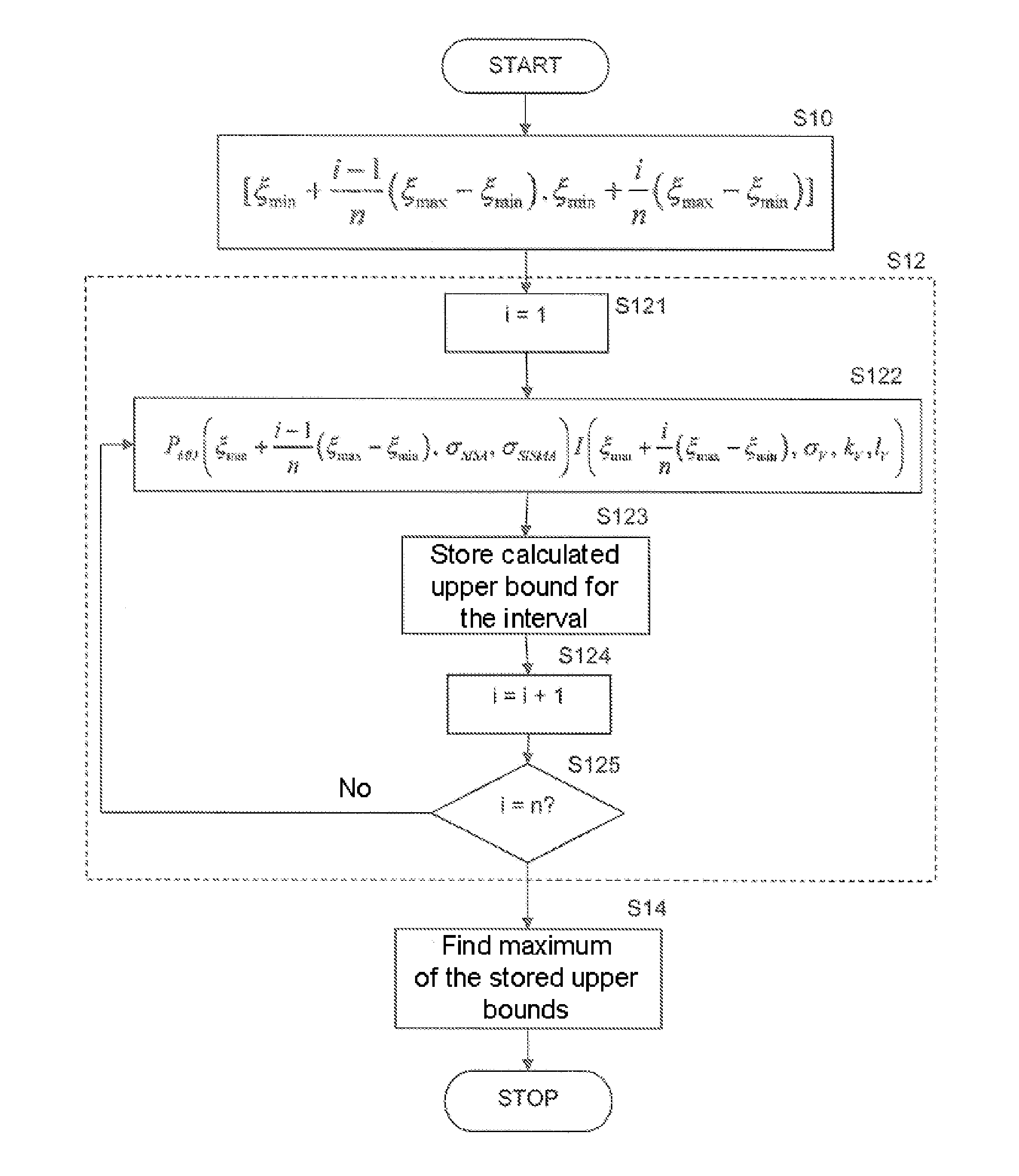
[0038]The present invention is based on the estimation of the integrity risk as explained in “Implementation and Testing of Galileo User Integrity Algorithms: New developments for the User Integrity Processing with Galileo” by F. Amarillo and D'Angelo, P., 4th ESA Workshop on Satellite Navigation User Equipment Technologies (NAVITEC'2008), Oct. 12, 2008, ESTEC-ESA, Noordwijk, The Netherlands. Accordingly, in Galileo the integrity risk RV can be calculated as the maximum of the following integral function:

RV=∫ξminξmaxPOCpdfOC(ξ)PMD(ξ,σSISA,σSISMA)I(ξ,σV,kV,IV)ξ

in which

POC is the probability for an “individual SIS” for non-nominal conditions,

pdf(ξ) is the probability density function of an undesired event in terms of the parameter 4,

PMD(ξ, σSISA, σSISMA) is the probability of an undesired event of an error detection, and

I(ξ, σV, kV, lV) is the probability of an undesired event of an effect on the application.

[0039]However, in practice it is difficult, if not completely impossible, to ...


PUM


Abstract

A method for estimating an integrity risk in a satellite navigation system includes receiving a plurality of navigation signals at a user system from at least one satellite, the plurality of navigation signals including data relative to the integrity of the satellite navigation system; and estimating the integrity risk using the data in the at least one user system. The estimating further includes forming a plurality of intervals of an integration variable of an integral function, estimating a maximum of the integrity risk for each interval, comparing the maximum of each interval to find an overall maximum of all the intervals; and using the overall maximum as an estimate of the integrity risk.

Description

[0001]Priority is claimed to German Patent Application No. DE 10 2009 016 337.9, filed Apr. 6, 2009, the entire disclosure of which is incorporated by reference herein.[0002]The invention relates to a method and a device for estimating the integrity risk in a satellite navigation system.BACKGROUND[0003]Global navigation satellite systems (GNSS; satellite navigation system for short) are used for position determination and navigation on the ground and in the air. GNSS systems, such as the European satellite navigation system currently under construction (also referred to hereinafter as the Galileo system or Galileo for short), comprise a satellite system (space segment) comprising a number of satellites, a receiving means system (ground segment) on the surface of the earth, connected to a central computation station and comprising a plurality of ground stations and Galileo sensor stations (GSS), and user systems, which evaluate and make use of the satellite signals transmitted by the...

Claims


Application Information

Patent Timeline
IPC IPC(8): G01S19/20
CPCG01S19/20
Inventor KRUEGER, JAN M. W.TRAUTENBERG, HANS L.
Owner AIRBUS DEFENCE & SPACE
Why Eureka
Try Eureka